METAR & TAF 2S0
2S0 does not publish a METAR.
Showing the nearest reporting station: KOMK (OMAK) · 23.9 NM away. Conditions at 2S0 may differ.
METAR · KOMK
Observed 05:53Z
KOMK 270553Z AUTO 09004KT 9SM CLR 24/01 A2991 RMK AO2 SLP121 T02440011 10317 20244 51016
- Wind
- 090° @ 4 kt
- Visibility
- 9 SM
- Temp / Dew
- 24°C / 1°C
- Altimeter
- 29.91 inHg
- Clouds
- CLR
- Density alt
- 3,079 ft
- Ceiling
- Unlimited
- Rules
- VFR
Airport info & contacts
Manager on record, flight service, ARTCC, attendance schedule and pattern altitude — published by the FAA and refreshed every 28 days.
Location
- From city
- 1 NM SE
- VFR sectional
- SEATTLE
- ARTCC
- ZSE · SEATTLE
- NOTAM facility
- SEA (NOTAM-D)
Airport manager
- Name
- ANDREW DURHAM
- Phone
- (509) 997-1311
- Address
- P.O. BOX 278, TWISP WA 98856
Flight service · Hours
- FSS SEA
- SEATTLE1-800-WX-BRIEF
- Attendance
- Unattended
Frequencies
Tap any row to copy the frequency to your clipboard.
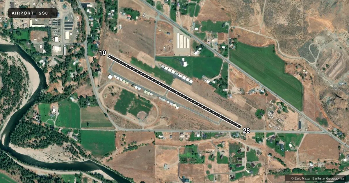
Runways & pattern
Full pagePattern entry · RWY 10
LEFT TRAFFICRunway end performance
| End | TORA | TODA | ASDA | LDA | VGSI | Approach lights | Obstruction |
|---|---|---|---|---|---|---|---|
| 10 | — | — | — | — | — | — | 30', trees, 290' from thr, 0' R of cntrln, slope 3 |
| 28 | — | — | — | — | PAPI 2-box left(4°) | — | 38', trees, 380' from thr, 0' R of cntrln, slope 4 |
Declared distances in feet. TORA = takeoff run available, TODA = takeoff distance, ASDA = accelerate-stop, LDA = landing distance.
Airport sketch
Runways drawn to scale from FAA survey coordinates, rendered over satellite imagery. Not for navigation.
Approaches & charts
Services on the field
Fuel grades, oxygen, maintenance, ramp storage and lighting — as declared to the FAA by the airport operator.
Fuel & services
- Fuel
- Not available
- Airframe repair
- Not available
- Power plant repair
- Not available
- Other services
- INSTR
Ramp & ground
- Transient storage
- Tie-down
- Landing fee
- No fee published
- Customs
- Not available
- Lighting schedule
- SEE RMK
- Beacon schedule
- SEE RMK
- Beacon
- White / Green (civil land)(WG)
- Wind indicator
- Yes
- Segmented circle
- No
Fuel & FBOs
Cheapest 100LL and Jet A on the field and nearby. Always confirm with the FBO before taxi.
Airport notes
Surface conditions, obstructions, local procedures, lighting outages and other notes published with each FAA cycle.
General notes
- DEER & PEDESTRIANS ON & INVOF ARPT.
- TREES; FENCE; ROAD IN PRIM SFC.
- MOUNTAINOUS TERRAIN SURROUNDS AIRPORT.
- ARPT CTAF FREQ 122.9; ANOTHER AIRPORT, METHOW VALLEY STATE (S52) WITHIN 8 NM CTAF FREQ 122.8.
- FOR CD CTC SEATTLE ARTCC AT 253-351-3694.
- FOR OKANOGAN MOA A AND B, FREQ 126.1
Lighting notes
- ACTVT ROTG BCN - CTAF.
- ACTVT MIRL RY 10/28 & PAPI RY 28 - CTAF.
Approach & departure obstructions
- 10+4 FT BRUSH & CLIFF WI 200 FT OF THR.
- 28ROAD 15 FT HI, 127 FT FM THR; ROAD 80 FT L, 15 FT HI; TREE 112 FT L, 30 FT HI; TREE 123 FT L, 55 FT FM THR.
- 28DSPLCD THR MARKED BY LIGHT FIXTURE.
- 28HAS A 50:1 APCH SLOPE TO DSPLCD THLD.
Other notes
- ESTABD PRIOR TO 15 MAY 1959.
- TIE DOWNS PILOT PROVIDED.
VFR map & nearby airports
VFR sectional. Tap any ICAO chip to open that airport.
Key facts · 2S0
Answer card- ICAO
- 2S0
- Name
- TWISP MUNI
- Location
- TWISP, WASHINGTON
- Elevation
- 1,602 ft MSL
- Traffic pattern altitude
- 2,602 ft MSL (1,000 AGL)
- Control tower
- Non-towered (use CTAF)
- Total runways
- 1
- Longest runway
- 10/28 · 2,701 ft
- Published ILS approaches
- 0
- Published frequencies
- 1
- Magnetic variation
- 20°
- Current flight rules
- VFR
- Current wind
- 090° at 4 kt
- Favored runway now
- RWY 10
Twisp Muni sits in Twisp, Washington at 1,602 ft MSL. It has one runway, 10/28, which is 2,701 ft long. There is no control tower. CTAF is 122.9. No ILS approaches are published here.
Pattern altitude is not published in the facts. Use the standard 1,000 ft AGL for light piston traffic unless the current Chart Supplement says otherwise. On the field, the runway lighting and the rotating beacon are activated by CTAF. Runway 28 also has a PAPI. The runway has a displaced threshold on 28. The threshold is marked by a light fixture.
No on-field FBOs are listed. Tie downs are pilot provided. Mountainous terrain surrounds the airport. That matters here. Expect to plan your descent early and keep an eye on terrain clearance, especially if you are arriving from lower country. There is also a brush and cliff hazard near the 10 threshold. Runway 28 has nearby road and tree obstructions close to the threshold area. If you need clearance delivery, Seattle ARTCC is listed in the remarks. For Okanogan MOA A and B, use 126.1.