METAR & TAF W01
W01 does not publish a METAR.
Showing the nearest reporting station: KOMK (OMAK) · 15.8 NM away. Conditions at W01 may differ.
METAR · KOMK
Observed 05:53Z
KOMK 270553Z AUTO 09004KT 9SM CLR 24/01 A2991 RMK AO2 SLP121 T02440011 10317 20244 51016
- Wind
- 090° @ 4 kt
- Visibility
- 9 SM
- Temp / Dew
- 24°C / 1°C
- Altimeter
- 29.91 inHg
- Clouds
- CLR
- Density alt
- 2,718 ft
- Ceiling
- Unlimited
- Rules
- VFR
Airport info & contacts
Manager on record, flight service, ARTCC, attendance schedule and pattern altitude — published by the FAA and refreshed every 28 days.
Location
- From city
- 2 NM NW
- VFR sectional
- SEATTLE
- ARTCC
- ZSE · SEATTLE
- NOTAM facility
- SEA (NOTAM-D)
Airport manager
- Name
- DARREN JOHNSON
- Phone
- 509-322-7432
- Address
- PO BOX 487, TONASKET WA 98855
Flight service · Hours
- FSS SEA
- SEATTLE1-800-WX-BRIEF
- Attendance
- Unattended
Frequencies
Tap any row to copy the frequency to your clipboard.
Runways & pattern
Full pagePattern entry · RWY 15
RIGHT TRAFFICRunway end performance
| End | TORA | TODA | ASDA | LDA | VGSI | Approach lights | Obstruction |
|---|---|---|---|---|---|---|---|
| 15 | — | — | — | — | PAPI 2-box left(5°) | — | 10', road, 570' from thr, 0' R of cntrln, slope 37 |
| 33 | — | — | — | — | PAPI 2-box left(4.5°) | — | 10', road, 439' from thr, 0' R of cntrln, slope 23 |
Declared distances in feet. TORA = takeoff run available, TODA = takeoff distance, ASDA = accelerate-stop, LDA = landing distance.
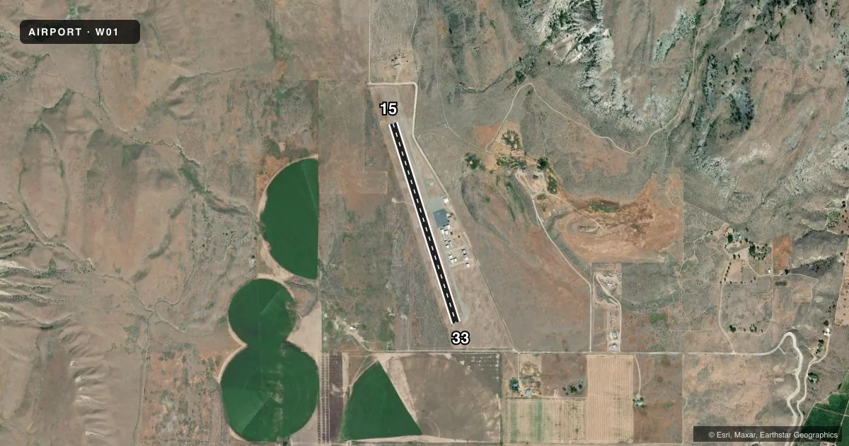
Airport sketch
Runways drawn to scale from FAA survey coordinates, rendered over satellite imagery. Not for navigation.
Approaches & charts
Services on the field
Fuel grades, oxygen, maintenance, ramp storage and lighting — as declared to the FAA by the airport operator.
Fuel & services
- Fuel
- Not available
Ramp & ground
- Transient storage
- Tie-down
- Lighting schedule
- SEE RMK
- Beacon
- White / Green (civil land)(WG)
- Wind indicator
- Lighted
- Segmented circle
- Yes
Fuel & FBOs
Cheapest 100LL and Jet A on the field and nearby. Always confirm with the FBO before taxi.
Airport notes
Surface conditions, obstructions, local procedures, lighting outages and other notes published with each FAA cycle.
General notes
- MTS ALL QUADS.
- DSTC TO GO MKRS S SIDE OF ARPT.
- FOR CD CTC SEATTLE ARTCC AT 253-351-3694.
Lighting notes
- ACTVT MIRL RWY 15/33 - CTAF.
Runway surface & condition
- 15/33NIGHT OPS WIND PMTG LND RWY 33; DEP RWY 15.
Other notes
- TIEDOWNS NA.
VFR map & nearby airports
VFR sectional. Tap any ICAO chip to open that airport.
Key facts · W01
Answer card- ICAO
- W01
- Name
- TONASKET MUNI
- Location
- TONASKET, WASHINGTON
- Elevation
- 1,311 ft MSL
- Traffic pattern altitude
- 2,311 ft MSL (1,000 AGL)
- Control tower
- Non-towered (use CTAF)
- Total runways
- 1
- Longest runway
- 15/33 · 3,053 ft
- Published ILS approaches
- 0
- Published frequencies
- 1
- Magnetic variation
- 20°
- Current flight rules
- VFR
- Current wind
- 090° at 4 kt
- Favored runway now
- RWY 15
Tonasket Muni sits in Tonasket, Washington. Field elevation is 1,311 ft MSL. The airport has one runway. Runway 15/33 is 3,053 ft of asphalt. There is no control tower. No ILS approaches are published. Pattern altitude is not published. Use the standard 1,000 ft AGL pattern for light piston aircraft unless the current Chart Supplement says otherwise.
The field is surrounded by mountains in all quadrants. That matters on arrival and departure. Expect terrain awareness to be part of the brief. Night ops on runway 15/33 require landing with the wind on runway 33 and departing from runway 15. Medium intensity runway lights on 15/33 are activated by the CTAF. CTAF is 122.9.
There are no on-field FBOs listed. Tiedowns are not available. For clearance delivery, contact Seattle ARTCC at 253-351-3694. The go markers are on the south side of the airport. A first-time pilot should verify current airport notes before launch, then plan the approach and departure with the surrounding terrain in mind.