METAR & TAF 0S7
0S7 does not publish a METAR.
Showing the nearest reporting station: KOMK (OMAK) · 30.0 NM away. Conditions at 0S7 may differ.
METAR · KOMK
Observed 05:53Z
KOMK 270553Z AUTO 09004KT 9SM CLR 24/01 A2991 RMK AO2 SLP121 T02440011 10317 20244 51016
- Wind
- 090° @ 4 kt
- Visibility
- 9 SM
- Temp / Dew
- 24°C / 1°C
- Altimeter
- 29.91 inHg
- Clouds
- CLR
- Density alt
- 2,418 ft
- Ceiling
- Unlimited
- Rules
- VFR
Airport info & contacts
Manager on record, flight service, ARTCC, attendance schedule and pattern altitude — published by the FAA and refreshed every 28 days.
Location
- From city
- 2 NM NE
- VFR sectional
- SEATTLE
- ARTCC
- ZSE · SEATTLE
- NOTAM facility
- SEA (NOTAM-D)
Airport manager
- Name
- STEVE THOMPSON
- Phone
- 509-476-2345
- Address
- PO BOX 1002, OROVILLE WA 98844
Flight service · Hours
- FSS SEA
- SEATTLE1-800-WX-BRIEF
- Attendance
- DAWN - DUSK
Frequencies
Tap any row to copy the frequency to your clipboard.
Runways & pattern
Full pagePattern entry · RWY 15
RIGHT TRAFFICRunway end performance
| End | TORA | TODA | ASDA | LDA | VGSI | Approach lights | Obstruction |
|---|---|---|---|---|---|---|---|
| 15 | — | — | — | — | — | — | 18', bldg, 850' from thr, 130' R of cntrln, slope 36 |
| 33 | — | — | — | — | — | — | 13', trees, 474' from thr, 0' R of cntrln, slope 21 |
Declared distances in feet. TORA = takeoff run available, TODA = takeoff distance, ASDA = accelerate-stop, LDA = landing distance.
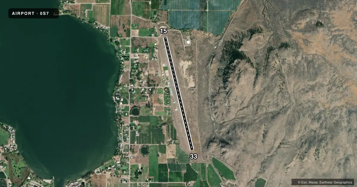
Airport sketch
Runways drawn to scale from FAA survey coordinates, rendered over satellite imagery. Not for navigation.
Approaches & charts
Services on the field
Fuel grades, oxygen, maintenance, ramp storage and lighting — as declared to the FAA by the airport operator.
Fuel & services
- Fuel
- 100LL
- Oxygen (bottled)
- Not available
- Oxygen (bulk)
- Not available
- Airframe repair
- Major
- Power plant repair
- Major
- Other services
- INSTR
Ramp & ground
- Transient storage
- Tie-down
- Landing fee
- No fee published
- Customs
- Available
- Lighting schedule
- SEE RMK
- Beacon schedule
- SS-SR
- Beacon
- White / Green (civil land)(WG)
- Wind indicator
- Lighted
- Segmented circle
- Yes
Fuel & FBOs
Cheapest 100LL and Jet A on the field and nearby. Always confirm with the FBO before taxi.
Airport notes
Surface conditions, obstructions, local procedures, lighting outages and other notes published with each FAA cycle.
General notes
- CUSTOMS TELEPHONE 509-476-2955.
- BRUSH, ROADS & TIE DOWNS IN PRIMARY SFC.
- FLIGHT NOTIFICTION SERVICE (ADCUS) AVBL.
- WILDLIFE ADJ TO RY/TWY.
- FOR CD CTC SEATTLE ARTCC AT 253-351-3694.
Lighting notes
- ARPT ROTG BCN LCTD 1500 FT EAST OF CNTRLN OF ARPT ON TOP OF HILL APRX 900 FT ABOVE ARPT ELEV.
- ACTVT MIRL RWY 15/33 - CTAF.
Approach & departure obstructions
- 15FADED.
- 33FADED.
Other notes
- EXISTED PRIOR TO 1959
- TIE DOWN ROPES PROVIDED BY PILOT
- 1ON CALL FOR SERVICE ALTERNATE NUMBER, 509-322-2887
- 15/33RWY 15/33 CRACKS IN TWY PAVEMENT.
VFR map & nearby airports
VFR sectional. Tap any ICAO chip to open that airport.
Key facts · 0S7
Answer card- ICAO
- 0S7
- Name
- DOROTHY SCOTT INTL
- Location
- OROVILLE, WASHINGTON
- Elevation
- 1,069 ft MSL
- Traffic pattern altitude
- 2,069 ft MSL (1,000 AGL)
- Control tower
- Non-towered (use CTAF)
- Total runways
- 1
- Longest runway
- 15/33 · 4,017 ft
- Published ILS approaches
- 0
- Published frequencies
- 1
- Magnetic variation
- 21°
- Current flight rules
- VFR
- Current wind
- 090° at 4 kt
- Favored runway now
- RWY 15
Dorothy Scott Intl is in Oroville, Washington. The field elevation is 1,069 ft MSL. It has one runway, 15/33, which is 4,017 ft long and asphalt. There is no control tower. CTAF is 122.9. No ILS approaches are published here.
The published pattern altitude is not listed. Use the current Chart Supplement before you go. The airport has one on-field FBO, Dorothy Scott International Airport. It carries 100LL. Call (509) 557-5165 for current service details. A second service number is listed as 509-322-2887.
A few remarks matter for planning. Wildlife is adjacent to the runway and taxiway. Brush, roads and tie downs are in the primary surface. Runway 15 and Runway 33 markings are faded. Tie down ropes must be provided by the pilot. The rotating beacon sits about 1,500 ft east of the airport centerline on top of a hill that is roughly 900 ft above airport elevation. That can help with night identification. The terrain and nearby obstructions deserve a careful look on arrival. Clearance delivery is handled through Seattle ARTCC at 253-351-3694. ADCUS flight notification service is available.