METAR & TAF KOMK
Current METAR
Observed 05:53Z
KOMK 270553Z AUTO 09004KT 9SM CLR 24/01 A2991 RMK AO2 SLP121 T02440011 10317 20244 51016
- Wind
- 090° @ 4 kt
- Visibility
- 9 SM
- Temp / Dew
- 24°C / 1°C
- Altimeter
- 29.91 inHg
- Clouds
- CLR
- Density alt
- 2,710 ft
- Ceiling
- Unlimited
- Rules
- VFR
Airport info & contacts
Manager on record, flight service, ARTCC, attendance schedule and pattern altitude — published by the FAA and refreshed every 28 days.
Location
- From city
- 3 NM N
- VFR sectional
- SEATTLE
- ARTCC
- ZSE · SEATTLE
- NOTAM facility
- OMK (NOTAM-D)
Airport manager
- Name
- WAYNE BEETCHENOW
- Phone
- 509-826-1170
- Address
- 2 NORTH ASH STREET, PO BOX 72, OMAK WA 98841
Flight service · Hours
- FSS SEA
- SEATTLE1-800-WX-BRIEF
- Attendance
- Unattended
Frequencies
Tap any row to copy the frequency to your clipboard.
Runways & pattern
Full pagePattern entry · RWY 35
LEFT TRAFFICRunway end performance
| End | TORA | TODA | ASDA | LDA | VGSI | Approach lights | Obstruction |
|---|---|---|---|---|---|---|---|
| 17 | — | — | — | — | PAPI 2-box left(3°) | — | — |
| 35 | — | — | — | — | PAPI 2-box left(3°) | — | — |
Declared distances in feet. TORA = takeoff run available, TODA = takeoff distance, ASDA = accelerate-stop, LDA = landing distance.
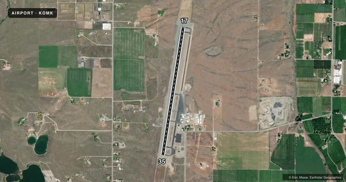
Airport sketch
Runways drawn to scale from FAA survey coordinates, rendered over satellite imagery. Not for navigation.
Approaches & charts
Services on the field
Fuel grades, oxygen, maintenance, ramp storage and lighting — as declared to the FAA by the airport operator.
Fuel & services
- Fuel
- 100LLA
- Oxygen (bottled)
- Not available
- Oxygen (bulk)
- Not available
- Airframe repair
- Not available
- Power plant repair
- Not available
- Other services
- AFRT,CHTR
Ramp & ground
- Transient storage
- Tie-down
- Landing fee
- No fee published
- Customs
- Not available
- Lighting schedule
- SEE RMK
- Beacon schedule
- SS-SR
- Beacon
- White / Green (civil land)(WG)
- Wind indicator
- Lighted
- Segmented circle
- Yes
Fuel & FBOs
Cheapest 100LL and Jet A on the field and nearby. Always confirm with the FBO before taxi.
Airport notes
Surface conditions, obstructions, local procedures, lighting outages and other notes published with each FAA cycle.
General notes
- FOR CD IF UNA TO CTC ON FSS FREQ, CTC SEATTLE ARTCC AT 253-351-3694.
- COLD TEMPERATURE AIRPORT. ALTITUDE CORRECTION REQUIRED AT OR BELOW -14C.
Lighting notes
- ACTVT REIL RWY 17 & 35; MIRL RWY 17/35, - CTAF. PAPI RWY 17 & 35 OPRS CONSLY.
Fuel notes
- 100LLFUEL AVBL 24 HRS - CREDIT CARD, NO GOVT CREDIT CARDS ACPTD.
Approach & departure obstructions
- 17UNUSBL BYD 2.5 NM, DOES NOT PRVD OBSTN CLNC BYD 2.5 NM FROM THR.
Other notes
- ESTABD PRIOR TO 15 MAY 1959.
- TIEDOWNS PROVIDED BY PILOT
- MANAGERCELL NMBR 509-322-4046, WKENDS ONLY.
VFR map & nearby airports
VFR sectional. Tap any ICAO chip to open that airport.
Key facts · KOMK
Answer card- ICAO
- KOMK
- Name
- OMAK
- Location
- OMAK, WASHINGTON
- Elevation
- 1,304.5 ft MSL
- Traffic pattern altitude
- 2,304.5 ft MSL (1,000 AGL)
- Control tower
- Non-towered (use CTAF)
- Total runways
- 1
- Longest runway
- 17/35 · 4,667 ft
- Published ILS approaches
- 0
- Published frequencies
- 2
- Magnetic variation
- 16°
- Current flight rules
- VFR
- Current wind
- 090° at 4 kt
- Favored runway now
- RWY 35
Omak Airport sits in Omak, Washington at 1,304.5 ft MSL. It has one runway, 17/35, which is 4,667 ft long and asphalt. The field is uncontrolled. CTAF and UNICOM are both 122.8. No ILS approaches are published here.
Use the published pattern altitude carefully. The facts block does not publish a specific value, so verify the current Chart Supplement before you fly. Runway lighting is pilot controlled on 122.8. REILs are available for both runway ends. PAPI is listed for runway 17 and runway 35. That helps for night work or a stabilized visual approach.
Omak Airport has one on-field FBO. Omak Airport carries 100LL and Jet A. 100LL is available 24 hours by credit card. Government credit cards are not accepted. If you need clearance delivery and cannot raise Flight Service, the published remark says to contact Seattle ARTCC at 253-351-3694. Runway 17 has a published limitation. It is unusable beyond 2.5 NM and does not provide obstacle clearance beyond that distance from the threshold. This is also a cold temperature airport. Altitude correction is required at or below minus 14 degrees Celsius. Tiedowns are provided by the pilot.