METAR & TAF 3W7
Current METAR
Observed 10:35Z
K3W7 271035Z AUTO 26003KT 10SM CLR 16/05 A2996 RMK AO2
- Wind
- 260° @ 3 kt
- Visibility
- 10 SM
- Temp / Dew
- 16°C / 5°C
- Altimeter
- 29.96 inHg
- Clouds
- CLR
- Density alt
- 2,046 ft
- Ceiling
- Unlimited
- Rules
- VFR
Airport info & contacts
Manager on record, flight service, ARTCC, attendance schedule and pattern altitude — published by the FAA and refreshed every 28 days.
Location
- From city
- 2 NM SW
- VFR sectional
- SEATTLE
- ARTCC
- ZSE · SEATTLE
- NOTAM facility
- SEA (NOTAM-D)
Airport manager
- Name
- ROBERT BABLER
- Phone
- 509-631-4797
- Address
- P.O. BOX 182, GRAND COULEE WA 99133
Flight service · Hours
- FSS SEA
- SEATTLE1-800-WX-BRIEF
- Attendance
- Unattended
Frequencies
Tap any row to copy the frequency to your clipboard.
Runways & pattern
Full pagePattern entry · RWY 22
RIGHT TRAFFICRunway end performance
| End | TORA | TODA | ASDA | LDA | VGSI | Approach lights | Obstruction |
|---|---|---|---|---|---|---|---|
| 04 | — | — | — | — | — | — | 490', hill, 9000' from thr, 0' R of cntrln, slope 17 |
| 22 | — | — | — | — | PAPI 2-box left(4.2°) | — | 30', gnd, 1195' from thr, 0' R of cntrln, slope 33 |
Declared distances in feet. TORA = takeoff run available, TODA = takeoff distance, ASDA = accelerate-stop, LDA = landing distance.
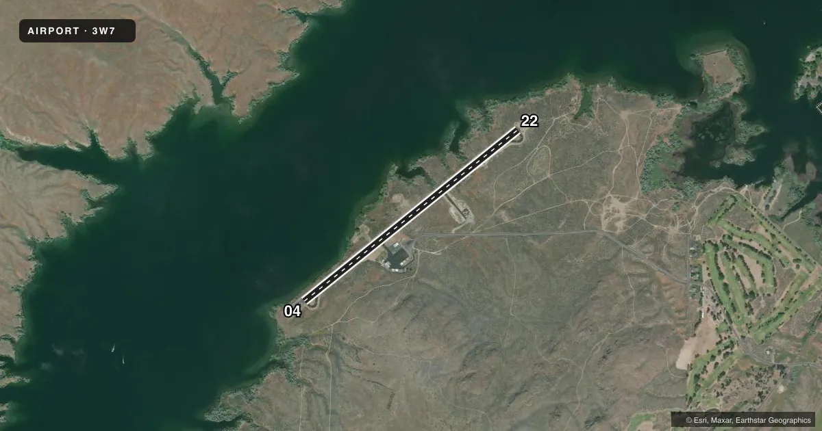
Airport sketch
Runways drawn to scale from FAA survey coordinates, rendered over satellite imagery. Not for navigation.
Approaches & charts
Services on the field
Fuel grades, oxygen, maintenance, ramp storage and lighting — as declared to the FAA by the airport operator.
Fuel & services
- Fuel
- Not available
- Oxygen (bottled)
- Not available
- Oxygen (bulk)
- Not available
- Airframe repair
- Not available
- Power plant repair
- Not available
Ramp & ground
- Transient storage
- Tie-down
- Landing fee
- No fee published
- Customs
- Not available
- Lighting schedule
- SEE RMK
- Beacon schedule
- SS-SR
- Beacon
- White / Green (civil land)(WG)
- Wind indicator
- Lighted
- Segmented circle
- Yes
Fuel & FBOs
Cheapest 100LL and Jet A on the field and nearby. Always confirm with the FBO before taxi.
Airport notes
Surface conditions, obstructions, local procedures, lighting outages and other notes published with each FAA cycle.
General notes
- GEESE & WILDLIFE INVOF RWY.
- FOR CD CTC SEATTLE ARTCC AT 253-351-3694.
Lighting notes
- ACTVT REIL RWY 22; PAPI RWY 22; MIRL RWY 04/22 - CTAF.
Approach & departure obstructions
- 0415 FT TREE 61 FT FM THR, 73 FT LEFT & DITCH 27 FT FM THR, 91 FT RIGHT.
- 22BRUSH 79 FT RIGHT; SLP & BRUSH 100 FT FM THR, 99 FT LEFT.
Other notes
- PILOTS BRING OWN ROPES.
VFR map & nearby airports
VFR sectional. Tap any ICAO chip to open that airport.
Key facts · 3W7
Answer card- ICAO
- 3W7
- Name
- GRAND COULEE DAM
- Location
- ELECTRIC CITY, WASHINGTON
- Elevation
- 1,593.1 ft MSL
- Traffic pattern altitude
- 2,593.1 ft MSL (1,000 AGL)
- Control tower
- Non-towered (use CTAF)
- Total runways
- 1
- Longest runway
- 04/22 · 4,203 ft
- Published ILS approaches
- 0
- Published frequencies
- 1
- Magnetic variation
- 15°
- Current flight rules
- VFR
- Current wind
- 260° at 3 kt
- Favored runway now
- RWY 22
Grand Coulee Dam Airport (3W7) sits in Electric City, Washington. Field elevation is 1,593.1 ft MSL. The airport has one runway. Runway 04/22 is 4,203 ft long on asphalt. There is no control tower. CTAF is 122.9.
No ILS approaches are published here. Pattern altitude is not published in the facts, so use standard 1,000 ft AGL for light piston operations unless the current Chart Supplement says otherwise. The published remarks matter here. Runway 22 has REILs, PAPI and medium intensity lighting controlled by CTAF. Runway 04 has medium intensity lighting as well. The field also has noted obstructions near both thresholds. Expect a tree and ditch near runway 04. Expect brush and a slope with brush near runway 22.
There are no on-field FBOs listed. Bring your own ropes. Wildlife is also noted in the runway area, so keep a sharp scan on taxi, takeoff and landing. For clearance delivery, contact Seattle ARTCC at 253-351-3694. If you need current operational details, check the current FAA Chart Supplement or call the airport operator directly before departure.