METAR & TAF 8W3
8W3 does not publish a METAR.
Showing the nearest reporting station: KEPH (EPHRATA MUNI) · 30.5 NM away. Conditions at 8W3 may differ.
METAR · KEPH
Observed 20:53Z
KEPH 262053Z AUTO 16010G18KT 10SM CLR 28/08 A2995 RMK AO2 SLP135 T02830083 58013
- Wind
- 160° @ 10G18 kt
- Visibility
- 10 SM
- Temp / Dew
- 28°C / 8°C
- Altimeter
- 29.95 inHg
- Clouds
- CLR
- Density alt
- 4,340 ft
- Ceiling
- Unlimited
- Rules
- VFR
Airport info & contacts
Manager on record, flight service, ARTCC, attendance schedule and pattern altitude — published by the FAA and refreshed every 28 days.
Location
- From city
- 0 NM E
- VFR sectional
- SEATTLE
- ARTCC
- ZSE · SEATTLE
- NOTAM facility
- SEA (NOTAM-D)
Airport manager
- Name
- TRENT MOYERS
- Phone
- 509-884-4700
- Address
- ONE CAMPBELL PARKWAY SUITE A, EAST WENATCHEE WA 98802
Flight service · Hours
- FSS SEA
- SEATTLE1-800-WX-BRIEF
- Attendance
- Unattended
Frequencies
Tap any row to copy the frequency to your clipboard.
Runways & pattern
Full pagePattern entry · RWY 21
LEFT TRAFFICRunway end performance
| End | TORA | TODA | ASDA | LDA | VGSI | Approach lights | Obstruction |
|---|---|---|---|---|---|---|---|
| 03 | 2,400' | — | — | — | — | — | 15', road, 350' from thr, 0' R of cntrln, slope 10 |
| 21 | 2,400' | — | — | — | — | — | 15', road, 300' from thr, 0' R of cntrln, slope 6 |
Declared distances in feet. TORA = takeoff run available, TODA = takeoff distance, ASDA = accelerate-stop, LDA = landing distance.
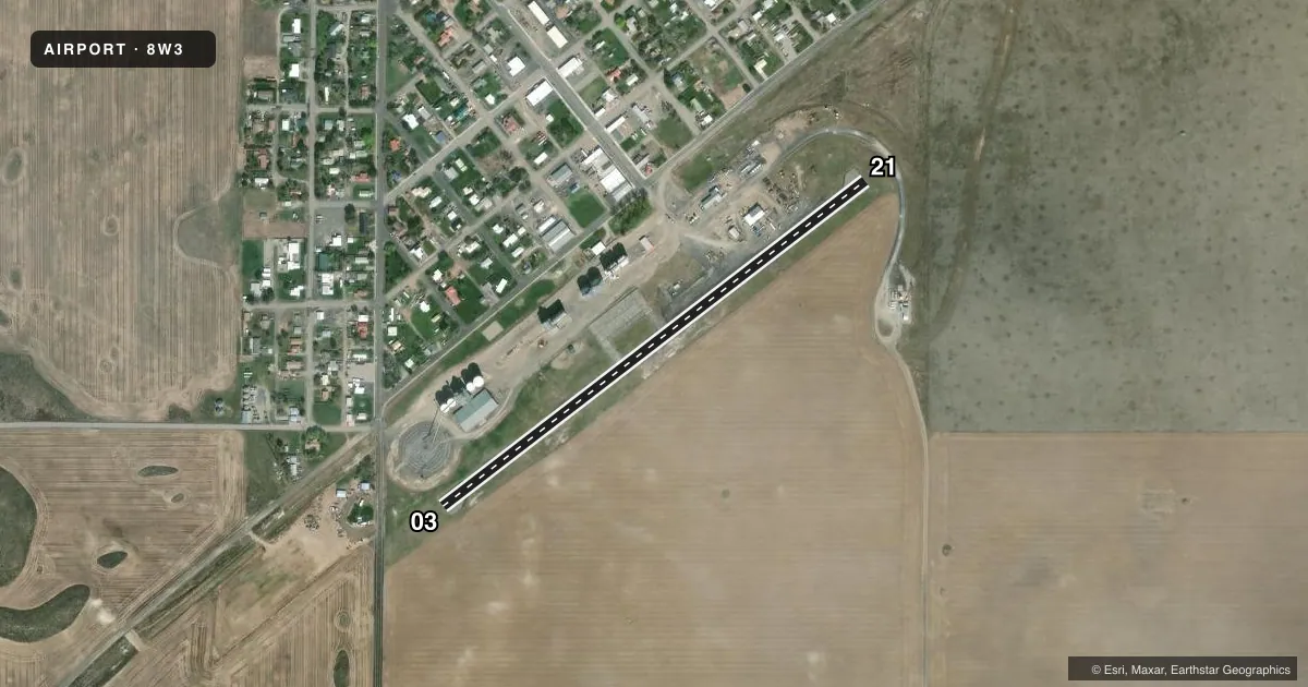
Airport sketch
Runways drawn to scale from FAA survey coordinates, rendered over satellite imagery. Not for navigation.
Approaches & charts
Services on the field
Fuel grades, oxygen, maintenance, ramp storage and lighting — as declared to the FAA by the airport operator.
Fuel & services
- Fuel
- Not available
- Oxygen (bottled)
- Not available
- Oxygen (bulk)
- Not available
- Airframe repair
- Not available
- Power plant repair
- Not available
Ramp & ground
- Transient storage
- Tie-down
- Landing fee
- No fee published
- Lighting schedule
- SS-SR
- Beacon schedule
- SS-SR
- Beacon
- White / Green (civil land)(WG)
- Wind indicator
- Lighted
- Segmented circle
- No
Fuel & FBOs
Cheapest 100LL and Jet A on the field and nearby. Always confirm with the FBO before taxi.
Airport notes
Surface conditions, obstructions, local procedures, lighting outages and other notes published with each FAA cycle.
General notes
- POSSIBLE TURBULENCE FROM GRAIN ELEVATORS N SIDE OF APRT.
- FOR CD CTC SEATTLE ARTCC AT 253-351-3694.
- NW PRKG HAS STEEP DROPOFF.
Lighting notes
- BCN TEMPO OTS.
Runway surface & condition
- 03/21NO RWY LGTS NORTHSIDE OF RWY END 21 TO MIDFIELD.
Approach & departure obstructions
- 03MARKINGS FADED.
- 21MARKINGS FADED.
Other notes
- RECORD PURPOSES ONLY.
- PILOTS BRING OWN ROPES.
- LGTD WIND TEE.
VFR map & nearby airports
VFR sectional. Tap any ICAO chip to open that airport.
Key facts · 8W3
Answer card- ICAO
- 8W3
- Name
- MANSFIELD
- Location
- MANSFIELD, WASHINGTON
- Elevation
- 2,272 ft MSL
- Traffic pattern altitude
- 3,272 ft MSL (1,000 AGL)
- Control tower
- Non-towered (use CTAF)
- Total runways
- 1
- Longest runway
- 03/21 · 2,575 ft
- Published ILS approaches
- 0
- Published frequencies
- 1
- Magnetic variation
- 20°
- Current flight rules
- VFR
- Current wind
- 160° at 10 kt
- Favored runway now
- RWY 21
Mansfield Airport (8W3) sits in Mansfield, Washington. Field elevation is 2,272 ft MSL. The airport has one runway, 03/21, which is 2,575 ft long with an asphalt surface. There is no control tower. CTAF is 122.9. No ILS approaches are published here.
The pattern altitude is not published. Use the standard 1,000 ft AGL pattern unless the current Chart Supplement says otherwise. That puts the light piston pattern at 3,272 ft MSL. The airport is small and simple, but the elevation is high enough to keep density altitude in mind on warm days. The published remarks also call out possible turbulence from grain elevators on the north side of the airport. The northwest parking area has a steep dropoff. Runway 03 and runway 21 markings are faded. There are no runway lights on the north side of runway end 21 to midfield. The beacon is temporarily out of service. Pilots should plan for daytime VFR use and verify any night plan with the current Chart Supplement before departure.
No on-field FBOs are listed. If you need fuel or ground handling, contact the airport operator directly or call the field on CTAF for current availability. The remarks also say pilots must bring their own ropes. For clearance delivery, contact Seattle ARTCC at 253-351-3694.