METAR & TAF 2S5
2S5 does not publish a METAR.
Showing the nearest reporting station: KEAT (PANGBORN MEML) · 16.6 NM away. Conditions at 2S5 may differ.
METAR · KEAT
Observed 12:55Z
KEAT 221255Z 27006KT 10SM CLR 22/11 A2994
- Wind
- 270° @ 6 kt
- Visibility
- 10 SM
- Temp / Dew
- 22°C / 11°C
- Altimeter
- 29.94 inHg
- Clouds
- CLR
- Density alt
- 4,095 ft
- Ceiling
- Unlimited
- Rules
- VFR
Airport info & contacts
Manager on record, flight service, ARTCC, attendance schedule and pattern altitude — published by the FAA and refreshed every 28 days.
Location
- From city
- 1 NM NE
- VFR sectional
- SEATTLE
- ARTCC
- ZSE · SEATTLE
- NOTAM facility
- SEA (NOTAM-D)
Airport manager
- Name
- TRENT MOYERS
- Phone
- 509-884-4700
- Address
- ONE CAMPBELL PARKWAY SUITE A, EAST WENATCHEE WA 98802
Flight service · Hours
- FSS SEA
- SEATTLE1-800-WX-BRIEF
- Attendance
- UNATTENDED
Frequencies
Tap any row to copy the frequency to your clipboard.
Runways & pattern
Full pagePattern entry · RWY 25
LEFT TRAFFICRunway end performance
| End | TORA | TODA | ASDA | LDA | VGSI | Approach lights | Obstruction |
|---|---|---|---|---|---|---|---|
| 07 | 2,800' | 2,800' | — | 2,500' | — | — | 20', road, 250' from thr, 130' R of cntrln, slope 2 |
| 25 | 2,500' | 2,500' | — | 2,500' | — | — | — |
Declared distances in feet. TORA = takeoff run available, TODA = takeoff distance, ASDA = accelerate-stop, LDA = landing distance.
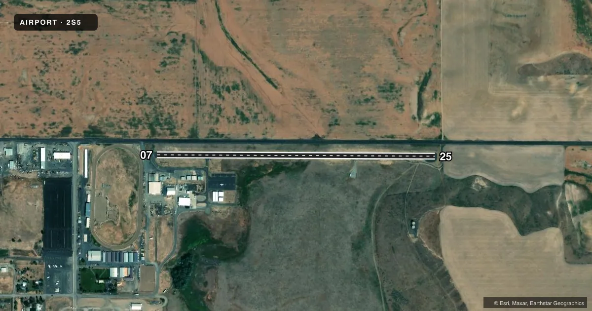
Airport sketch
Runways drawn to scale from FAA survey coordinates, rendered over satellite imagery. Not for navigation.
Approaches & charts
Services on the field
Fuel grades, oxygen, maintenance, ramp storage and lighting — as declared to the FAA by the airport operator.
Fuel & services
- Fuel
- Not available
- Oxygen (bottled)
- Not available
- Oxygen (bulk)
- Not available
- Airframe repair
- Not available
- Power plant repair
- Not available
- Other services
- AGRI
Ramp & ground
- Transient storage
- Tie-down
- Landing fee
- No fee published
- Customs
- Not available
- Lighting schedule
- SS-SR
- Beacon schedule
- SS-SR
- Beacon
- White / Green (civil land)(WG)
- Wind indicator
- Lighted
- Segmented circle
- No
Fuel & FBOs
Cheapest 100LL and Jet A on the field and nearby. Always confirm with the FBO before taxi.
Airport notes
Surface conditions, obstructions, local procedures, lighting outages and other notes published with each FAA cycle.
General notes
- HILL ON S SIDE OF RY IN TRAN SFC.
- RWY SHOULDERS SOFT IN WET WEATHER.
- FOR CD CTC SEATTLE ARTCC AT 253-351-3694.
Other notes
- ESTABD PRIOR TO 15 MAY 1959.
- PILOTS BRING OWN ROPES.
- LIGHTED WIND TEE.
VFR map & nearby airports
VFR sectional. Tap any ICAO chip to open that airport.
Key facts · 2S5
Answer card- ICAO
- 2S5
- Name
- WATERVILLE
- Location
- WATERVILLE, WASHINGTON
- Elevation
- 2,645 ft MSL
- Traffic pattern altitude
- 3,645 ft MSL (1,000 AGL)
- Control tower
- Non-towered (use CTAF)
- Total runways
- 1
- Longest runway
- 07/25 · 2,978 ft
- Published ILS approaches
- 0
- Published frequencies
- 1
- Magnetic variation
- 20°
- Current flight rules
- VFR
- Current wind
- 270° at 6 kt
- Favored runway now
- RWY 25
Waterville Airport (2S5) sits in Waterville, Washington. The field elevation is 2,645 ft MSL. It has one runway, 07/25, which is 2,978 ft long. There is no control tower. CTAF is 122.9. No ILS approaches are published here.
The pattern altitude is not published. Use the standard 1,000 ft AGL for light piston traffic unless the current Chart Supplement says otherwise. That puts the working pattern at about 3,645 ft MSL. The airport is established on a hillier part of the area. A hill sits on the south side of the runway in the transition surface. Plan your arrival with that in mind, especially in marginal winds or if you are new to the strip.
Published remarks also note soft runway shoulders in wet weather. Keep that in mind if you are operating a heavier airplane or if the surface is damp. A lighted wind tee is available. There are no on-field FBOs listed, so verify fuel and ground support with the airport operator or the field directly before you go. Clearance delivery is handled through Seattle ARTCC at 253-351-3694. Pilots must bring their own ropes.