METAR & TAF 27W
27W does not publish a METAR.
Showing the nearest reporting station: KEAT (PANGBORN MEML) · 32.7 NM away. Conditions at 27W may differ.
METAR · KEAT
Observed 12:55Z
KEAT 221255Z 27006KT 10SM CLR 22/11 A2994
- Wind
- 270° @ 6 kt
- Visibility
- 10 SM
- Temp / Dew
- 22°C / 11°C
- Altimeter
- 29.94 inHg
- Clouds
- CLR
- Density alt
- 3,220 ft
- Ceiling
- Unlimited
- Rules
- VFR
Airport info & contacts
Manager on record, flight service, ARTCC, attendance schedule and pattern altitude — published by the FAA and refreshed every 28 days.
Location
- From city
- 14 NM NW
- VFR sectional
- SEATTLE
- ARTCC
- ZSE · SEATTLE
- NOTAM facility
- SEA (NOTAM-D)
Airport manager
- Name
- JOHN WILSON
- Phone
- 360-618-2477
- Address
- PO BOX 47312, OLYMPIA WA 98504-7264
Flight service · Hours
- FSS SEA
- SEATTLE1-800-WX-BRIEF
- Attendance
- Unattended
Frequencies
Tap any row to copy the frequency to your clipboard.
Runways & pattern
Full pagePattern entry · RWY 27
LEFT TRAFFICRunway end performance
| End | TORA | TODA | ASDA | LDA | VGSI | Approach lights | Obstruction |
|---|---|---|---|---|---|---|---|
| 09 | — | — | — | — | — | — | 15', road, 0' from thr, 105' R of cntrln, slope 0 |
| 27 | — | — | — | — | — | — | 15', road, 0' from thr, 104' R of cntrln, slope 0 |
Declared distances in feet. TORA = takeoff run available, TODA = takeoff distance, ASDA = accelerate-stop, LDA = landing distance.
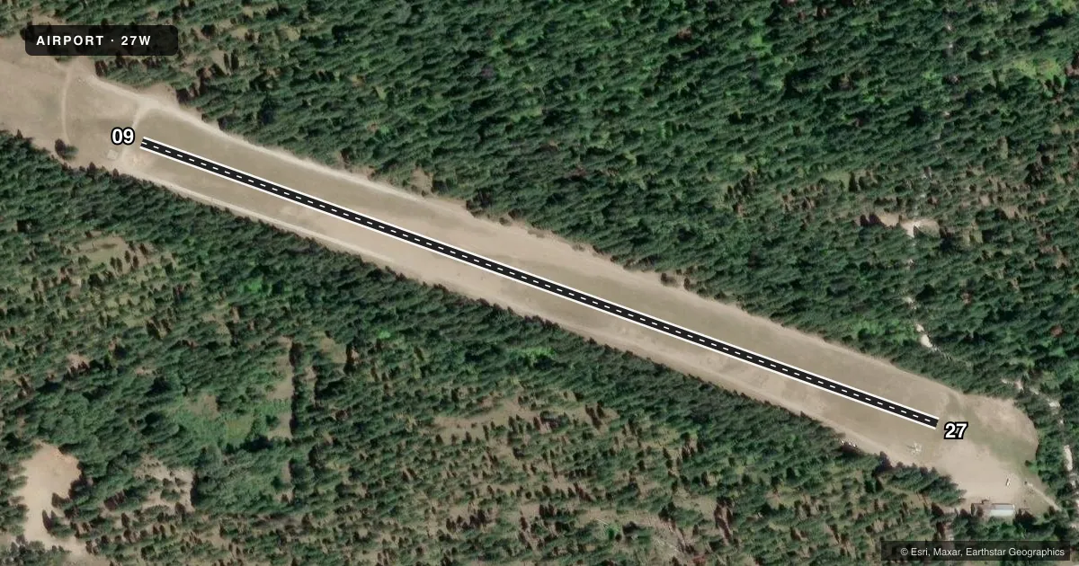
Airport sketch
Runways drawn to scale from FAA survey coordinates, rendered over satellite imagery. Not for navigation.
Approaches & charts
Services on the field
Fuel grades, oxygen, maintenance, ramp storage and lighting — as declared to the FAA by the airport operator.
Fuel & services
- Fuel
- Not available
- Oxygen (bottled)
- Not available
- Oxygen (bulk)
- Not available
- Airframe repair
- Not available
- Power plant repair
- Not available
Ramp & ground
- Transient storage
- Tie-down
- Landing fee
- No fee published
- Customs
- Not available
- Wind indicator
- Yes
- Segmented circle
- No
Fuel & FBOs
Cheapest 100LL and Jet A on the field and nearby. Always confirm with the FBO before taxi.
Airport notes
Surface conditions, obstructions, local procedures, lighting outages and other notes published with each FAA cycle.
General notes
- ARPT CLSD 1 OCT-1 JUN.
- PEDESTRIANS; VEHICLES AND ANIMALS ON & INVOF RY.
- RY MARKED WITH REFLECTORS DURING DATES AIRPORT IS OPEN.
Approach & departure obstructions
- 0975 FT TREES 1000 FT PAST RY END BOTH SIDES OF CNTRLN.
- 2770 FT TREES 450 FT PAST RY END, BOTH SIDES OF CNTRLN.
Other notes
- ESTBD PRIOR TO MAY 1959.
- PILOT PROVD OWN CHAINS FOR TIEDOWN.
VFR map & nearby airports
VFR sectional. Tap any ICAO chip to open that airport.
Key facts · 27W
Answer card- ICAO
- 27W
- Name
- LAKE WENATCHEE STATE
- Location
- LEAVENWORTH, WASHINGTON
- Elevation
- 1,939 ft MSL
- Traffic pattern altitude
- 2,939 ft MSL (1,000 AGL)
- Control tower
- Non-towered (use CTAF)
- Total runways
- 1
- Longest runway
- 09/27 · 2,473 ft
- Published ILS approaches
- 0
- Published frequencies
- 1
- Magnetic variation
- 20°
- Current flight rules
- VFR
- Current wind
- 270° at 6 kt
- Favored runway now
- RWY 27
Lake Wenatchee State Airport (27W) sits near Leavenworth, Washington at 1,939 ft MSL. It has one runway. Runway 09/27 is 2,473 ft of turf. The field is not towered. CTAF is 122.9. No ILS approaches are published here. Pattern altitude is not published, so use 1,000 ft AGL for light piston operations unless current airport guidance says otherwise. That puts the traffic pattern at 2,939 ft MSL based on the listed field elevation.
This is a seasonal field. The airport is closed from October 1 to June 1. Plan around that before you launch. Published remarks also call out trees beyond both runway ends. On runway 27, there are 70-foot trees about 450 feet past the end on both sides of the centerline. On runway 09, there are 75-foot trees about 1,000 feet past the end on both sides of the centerline. The runway is marked with reflectors during the open season. Expect pedestrians, vehicles and animals near the runway. Bring your own chains for tiedown. No on-field FBOs are listed, so verify services with the airport operator or the FBO directly by phone before you go.