METAR & TAF S10
S10 does not publish a METAR.
Showing the nearest reporting station: KEAT (PANGBORN MEML) · 30.0 NM away. Conditions at S10 may differ.
METAR · KEAT
Observed 12:55Z
KEAT 221255Z 27006KT 10SM CLR 22/11 A2994
- Wind
- 270° @ 6 kt
- Visibility
- 10 SM
- Temp / Dew
- 22°C / 11°C
- Altimeter
- 29.94 inHg
- Clouds
- CLR
- Density alt
- 2,381 ft
- Ceiling
- Unlimited
- Rules
- VFR
Airport info & contacts
Manager on record, flight service, ARTCC, attendance schedule and pattern altitude — published by the FAA and refreshed every 28 days.
Location
- From city
- 3 NM NE
- VFR sectional
- SEATTLE
- ARTCC
- ZSE · SEATTLE
- NOTAM facility
- SEA (NOTAM-D)
Airport manager
- Name
- LAURA MCALOON
- Phone
- 509-682-8014
- Address
- PO BOX 1669, CHELAN WA 98816
Flight service · Hours
- FSS SEA
- SEATTLE1-800-WX-BRIEF
- Attendance
- MON-FRI · 0700-1500
Frequencies
Tap any row to copy the frequency to your clipboard.
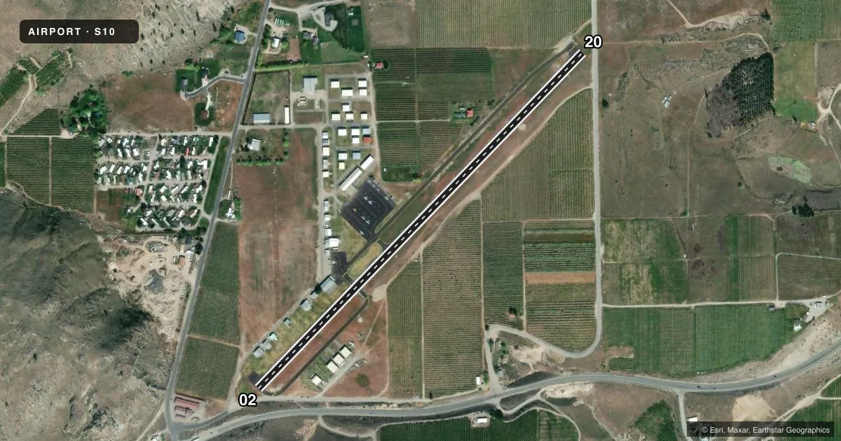
Runways & pattern
Full pagePattern entry · RWY 20
LEFT TRAFFICRunway end performance
| End | TORA | TODA | ASDA | LDA | VGSI | Approach lights | Obstruction |
|---|---|---|---|---|---|---|---|
| 02 | — | — | — | — | — | — | 15', road, 203' from thr, 0' R of cntrln, slope 0 |
| 20 | — | — | — | — | PAPI 2-box left | — | — |
Declared distances in feet. TORA = takeoff run available, TODA = takeoff distance, ASDA = accelerate-stop, LDA = landing distance.
Airport sketch
Runways drawn to scale from FAA survey coordinates, rendered over satellite imagery. Not for navigation.
Approaches & charts
Services on the field
Fuel grades, oxygen, maintenance, ramp storage and lighting — as declared to the FAA by the airport operator.
Fuel & services
- Fuel
- 100LLA
- Oxygen (bottled)
- Not available
- Oxygen (bulk)
- Not available
- Airframe repair
- Minor
- Power plant repair
- Minor
- Other services
- PAJA
Ramp & ground
- Transient storage
- Tie-down
- Landing fee
- No fee published
- Customs
- Not available
- Lighting schedule
- SEE RMK
- Beacon schedule
- SS-SR
- Beacon
- White / Green (civil land)(WG)
- Wind indicator
- Lighted
- Segmented circle
- Yes
Fuel & FBOs
Cheapest 100LL and Jet A on the field and nearby. Always confirm with the FBO before taxi.
Airport notes
Surface conditions, obstructions, local procedures, lighting outages and other notes published with each FAA cycle.
General notes
- RY 20 IS PREFD APRCH RY.
- MAY THROUGH OCTOBER PARACHUTE JUMPING ACTIVITIES ON AIRFIELD.
- FOR CD CTC SEATTLE ARTCC AT 253-351-3694.
Lighting notes
- ACTVT MIRL RY 02/20 - CTAF.
Fuel notes
- 100LLSELF-SERVICE FUEL AVAILABLE 24/7
Approach & departure obstructions
- 02RWY 02, ROAD 0-200 FT FM THR ON BOTH SIDES, ROAD SIGN +7 FT, 170 FT FM THR, 77 FT L, 2 FT UTILITY BOX 110 FT FM THR, 78 FT L.
- 20RWY 20 ROAD IN PRIM SFC 125 FT FM THR; ROAD AT 124 FT FM THR AND 4 FT SIGNS 119 FT FM THR; 3 FT SIGN 18 FT FM THR, 67 FT R; 2 FT SIGN 18 FT FM THR, 72 FT R; 2 FT PIPE 81 FT FM THR, 15 FT L; 2 FT SIGN 23 FT FM THR, 79 L; 5 FT SIGN 188 FT FM THR, 65 FT R.
- 02APCH SLOPE 46:1 FROM DSPLCD THR.
- 20RY 20 APPROACH SLOPE 14:1 TO +19 FT ROAD AT 322 FT FROM DISPLCD THLD.
Other notes
- ESTABD PRIOR TO 15 MAY 1959.
- PIL0TS BRING OWN ROPES.
- AUTOMATED UNICOM.
VFR map & nearby airports
VFR sectional. Tap any ICAO chip to open that airport.
Key facts · S10
Answer card- ICAO
- S10
- Name
- LAKE CHELAN
- Location
- CHELAN, WASHINGTON
- Elevation
- 1,263.1 ft MSL
- Traffic pattern altitude
- 2,263.1 ft MSL (1,000 AGL)
- Control tower
- Non-towered (use CTAF)
- Total runways
- 1
- Longest runway
- 02/20 · 3,506 ft
- Published ILS approaches
- 0
- Published frequencies
- 2
- Magnetic variation
- 20°
- Current flight rules
- VFR
- Current wind
- 270° at 6 kt
- Favored runway now
- RWY 20
Lake Chelan Airport sits in Chelan, Washington. Field elevation is 1,263.1 ft MSL. The airport has one runway. Runway 02/20 is 3,506 ft long with asphalt pavement. There is no control tower. CTAF is 122.9. UNICOM is 122.95. No ILS approaches are published here.
Pattern altitude is not published. Use 1,000 ft AGL as the standard light piston pattern unless the current Chart Supplement or local traffic calls for something different. The field has one on-field FBO, Chelan Municipal Airport. It carries 100LL and Jet A. Self-serve 100LL is available 24 hours a day, 7 days a week. Medium intensity runway lights on 02/20 are activated by CTAF.
This is a field where you want to brief the runway environment before arrival. Runway 20 is the preferred approach runway. Published remarks call out roads and other obstructions near both runway ends, with more detail on 02 and 20. Parachute jumping occurs on the airfield from May through October. For clearance delivery, Seattle ARTCC can be reached at 253-351-3694. Pilots should also bring their own ropes. Expect a non-towered pattern and verify current procedures before you go.