METAR & TAF 6S9
6S9 does not publish a METAR.
Showing the nearest reporting station: KOMK (OMAK) · 48.5 NM away. Conditions at 6S9 may differ.
METAR · KOMK
Observed 05:53Z
KOMK 270553Z AUTO 09004KT 9SM CLR 24/01 A2991 RMK AO2 SLP121 T02440011 10317 20244 51016
- Wind
- 090° @ 4 kt
- Visibility
- 9 SM
- Temp / Dew
- 24°C / 1°C
- Altimeter
- 29.91 inHg
- Clouds
- CLR
- Density alt
- 2,618 ft
- Ceiling
- Unlimited
- Rules
- VFR
Airport info & contacts
Manager on record, flight service, ARTCC, attendance schedule and pattern altitude — published by the FAA and refreshed every 28 days.
Location
- From city
- 3 NM NW
- VFR sectional
- SEATTLE
- ARTCC
- ZSE · SEATTLE
- NOTAM facility
- SEA (NOTAM-D)
Airport manager
- Name
- JOHN WILSON
- Phone
- 360-618-2477
- Address
- PO BOX 47312, OLYMPIA WA 98504-7264
Flight service · Hours
- FSS SEA
- SEATTLE1-800-WX-BRIEF
- Attendance
- Unattended
Frequencies
Tap any row to copy the frequency to your clipboard.
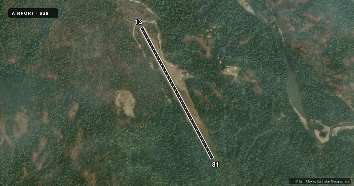
Runways & pattern
Full pagePattern entry · RWY 13
LEFT TRAFFICRunway end performance
| End | TORA | TODA | ASDA | LDA | VGSI | Approach lights | Obstruction |
|---|---|---|---|---|---|---|---|
| 13 | — | — | — | — | — | — | 10', road, 150' from thr, 0' R of cntrln, slope 15 |
| 31 | — | — | — | — | — | — | 84', trees, 1006' from thr, 0' R of cntrln, slope 11 |
Declared distances in feet. TORA = takeoff run available, TODA = takeoff distance, ASDA = accelerate-stop, LDA = landing distance.
Airport sketch
Runways drawn to scale from FAA survey coordinates, rendered over satellite imagery. Not for navigation.
Approaches & charts
Services on the field
Fuel grades, oxygen, maintenance, ramp storage and lighting — as declared to the FAA by the airport operator.
Fuel & services
- Fuel
- Not available
- Oxygen (bottled)
- Not available
- Oxygen (bulk)
- Not available
- Airframe repair
- Not available
- Power plant repair
- Not available
Ramp & ground
- Transient storage
- Tie-down
- Landing fee
- No fee published
- Wind indicator
- Yes
- Segmented circle
- No
Fuel & FBOs
Cheapest 100LL and Jet A on the field and nearby. Always confirm with the FBO before taxi.
Airport notes
Surface conditions, obstructions, local procedures, lighting outages and other notes published with each FAA cycle.
General notes
- ARPT CLSD 1 OCT-1 JUN, EXC FOR PUB SAFETY/LAW ENFOCEMENT HOPS. NO MIL USE EXC EMERG.
- VEHICLES, PEDESTRIANS, AND ANIMALS ON & INVOF RY.
- CAUTION--DENSITY ALTITUDE.
- FOR CD CTC SEATTLE ARTCC AT 253-351-3694.
Approach & departure obstructions
- 31TREES IN THE APPROACH AREA
- 31RWY 31 EXTEND TOUCHDOWN 3OOFT PAST THRSHOLD ROUGH SURFACE
Other notes
- ESTABD PRIOR TO 15 MAY 59.
- PILOTS PROVD OWN TIEDOWN CHAINS.
VFR map & nearby airports
VFR sectional. Tap any ICAO chip to open that airport.
Key facts · 6S9
Answer card- ICAO
- 6S9
- Name
- STEHEKIN STATE
- Location
- STEHEKIN, WASHINGTON
- Elevation
- 1,230 ft MSL
- Traffic pattern altitude
- 2,230 ft MSL (1,000 AGL)
- Control tower
- Non-towered (use CTAF)
- Total runways
- 1
- Longest runway
- 13/31 · 2,630 ft
- Published ILS approaches
- 0
- Published frequencies
- 1
- Magnetic variation
- 20°
- Current flight rules
- VFR
- Current wind
- 090° at 4 kt
- Favored runway now
- RWY 13
Stehekin State Airport is in Stehekin, Washington. The field elevation is 1,230 ft MSL. It has one runway. Runway 13/31 is 2,630 ft long and turf. There is no control tower. CTAF is 122.9. No ILS approaches are published.
The published pattern altitude is not listed, so use the standard 1,000 ft AGL pattern unless the current Chart Supplement says otherwise. On this field that puts the pattern near 2,230 ft MSL. The airport sits in a mountain setting. Density altitude is a real factor here. Trees are in the approach area for runway 31. Runway 31 also has a rough surface and extends touchdown 300 feet past the threshold. Expect wildlife, people, vehicles and other activity near the runway. This is not a place to get casual on short final.
There are no on-field FBOs listed. Pilots should plan to be self-sufficient. The remarks also say to provide your own tiedown chains. The airport is closed from 1 October to 1 June except for public safety and law enforcement hops. For clearance delivery, contact Seattle ARTCC at 253-351-3694.