METAR & TAF R49
R49 does not publish a METAR.
Showing the nearest reporting station: KOMK (OMAK) · 37.5 NM away. Conditions at R49 may differ.
METAR · KOMK
Observed 05:53Z
KOMK 270553Z AUTO 09004KT 9SM CLR 24/01 A2991 RMK AO2 SLP121 T02440011 10317 20244 51016
- Wind
- 090° @ 4 kt
- Visibility
- 9 SM
- Temp / Dew
- 24°C / 1°C
- Altimeter
- 29.91 inHg
- Clouds
- CLR
- Density alt
- 4,220 ft
- Ceiling
- Unlimited
- Rules
- VFR
Airport info & contacts
Manager on record, flight service, ARTCC, attendance schedule and pattern altitude — published by the FAA and refreshed every 28 days.
Location
- From city
- 6 NM NE
- VFR sectional
- SEATTLE
- Pattern altitude
- 800 ft AGL · 3,322 ft MSL
- ARTCC
- ZSE · SEATTLE
- NOTAM facility
- SEA (NOTAM-D)
Airport manager
- Name
- TERRY THIELE
- Phone
- 616 822-0483
- Address
- 350 EAST DELAWARE #8, REPUBLIC WA 99166
Flight service · Hours
- FSS SEA
- SEATTLE1-800-WX-BRIEF
- Attendance
- Unattended
Frequencies
Tap any row to copy the frequency to your clipboard.
Runways & pattern
Full pagePattern entry · RWY 35
LEFT TRAFFICRunway end performance
| End | TORA | TODA | ASDA | LDA | VGSI | Approach lights | Obstruction |
|---|---|---|---|---|---|---|---|
| 17 | — | — | — | — | — | — | 61', trees, 1022' from thr, 0' R of cntrln, slope 13 |
| 35 | — | — | — | — | PAPI 2-box left(4°) | — | 23', trees, 432' from thr, 0' R of cntrln, slope 10 |
Declared distances in feet. TORA = takeoff run available, TODA = takeoff distance, ASDA = accelerate-stop, LDA = landing distance.
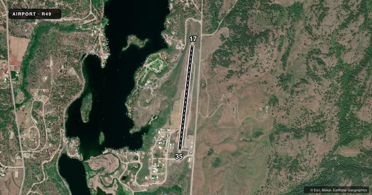
Airport sketch
Runways drawn to scale from FAA survey coordinates, rendered over satellite imagery. Not for navigation.
Approaches & charts
Services on the field
Fuel grades, oxygen, maintenance, ramp storage and lighting — as declared to the FAA by the airport operator.
Fuel & services
- Fuel
- Not available
- Oxygen (bottled)
- Not available
- Oxygen (bulk)
- Not available
- Airframe repair
- Not available
- Power plant repair
- Not available
Ramp & ground
- Transient storage
- Tie-down
- Landing fee
- No fee published
- Customs
- Not available
- Lighting schedule
- SEE RMK
- Beacon schedule
- SS-SR
- Beacon
- White / Green (civil land)(WG)
- Wind indicator
- Lighted
- Segmented circle
- No
Fuel & FBOs
Cheapest 100LL and Jet A on the field and nearby. Always confirm with the FBO before taxi.
Airport notes
Surface conditions, obstructions, local procedures, lighting outages and other notes published with each FAA cycle.
General notes
- SUGGEST NGT LNDGS BE MADE ON RY 35.
- RY 17/35 TREES LCTD ON UNLGTD UNMKD MOUNTAINOUS TRRN.
- PLINES NE OF RY 17 LGTD DUSK-DAWN.
- WILDLIFE INVOF OF RUNWAY.
- FOR CD CTC SEATTLE ARTCC AT 253-351-3694.
Lighting notes
- ACTVT PAPI RWY 35; MIRL RWY 17/35 - 122.8.
Approach & departure obstructions
- 35RWY 35, SLOPE 69 FT R AND 59 FT L FM EDGE OF RWY.
- 17RWY MRKGS FADED.
- 35RWY MRKGS FADED.
Other notes
- MANAGERSHERIFF OFC 509-775-3132.
VFR map & nearby airports
VFR sectional. Tap any ICAO chip to open that airport.
Key facts · R49
Answer card- ICAO
- R49
- Name
- FERRY COUNTY
- Location
- REPUBLIC, WASHINGTON
- Elevation
- 2,522 ft MSL
- Traffic pattern altitude
- 3,322 ft MSL (800 AGL)
- Control tower
- Non-towered (use CTAF)
- Total runways
- 1
- Longest runway
- 17/35 · 3,498 ft
- Published ILS approaches
- 0
- Published frequencies
- 1
- Magnetic variation
- 20°
- Current flight rules
- VFR
- Current wind
- 090° at 4 kt
- Favored runway now
- RWY 35
Ferry County Airport sits in Republic, Washington. The field elevation is 2,522 ft MSL. It has one runway, 17/35, which is 3,498 ft long and asphalt. There is no control tower. CTAF is 122.9. Pattern altitude is 800 ft AGL, which is 3,322 ft MSL.
No ILS approaches are published here. The runway environment deserves a close look before you go in. Published remarks note faded runway markings on both ends. Runway 35 has a slope with obstructions close to the edge. Trees are also reported near runway 17/35 on unlighted mountainous terrain. Wildlife is in the vicinity of the runway. Night landings are suggested on runway 35. PAPI is available on runway 35. Medium intensity runway lights serve runways 17 and 35. They are controlled on 122.8. Pilot-controlled lighting northeast of runway 17 is lighted from dusk to dawn.
No on-field FBOs are listed. Check current services with the airport operator before you go. For clearance delivery, Seattle ARTCC is listed in the remarks. This is a mountain airport with a relatively short runway at elevation, so plan performance carefully and verify current runway and lighting details before departure.