METAR & TAF S23
S23 does not publish a METAR.
Showing the nearest reporting station: KSZT (SANDPOINT) · 41.9 NM away. Conditions at S23 may differ.
METAR · KSZT
Observed 17:15Z
KSZT 271715Z AUTO 15009KT 10SM CLR 25/05 A3006 RMK AO2
- Wind
- 150° @ 9 kt
- Visibility
- 10 SM
- Temp / Dew
- 25°C / 5°C
- Altimeter
- 30.06 inHg
- Clouds
- CLR
- Density alt
- 3,642 ft
- Ceiling
- Unlimited
- Rules
- VFR
Airport info & contacts
Manager on record, flight service, ARTCC, attendance schedule and pattern altitude — published by the FAA and refreshed every 28 days.
Location
- From city
- 2 NM S
- VFR sectional
- SEATTLE
- ARTCC
- ZSE · SEATTLE
- NOTAM facility
- SEA (NOTAM-D)
Airport manager
- Name
- DAN NUTT
- Phone
- 509-690-2580
- Address
- PO BOX 498, IONE WA 99139
Flight service · Hours
- FSS SEA
- SEATTLE1-800-WX-BRIEF
- Attendance
- Unattended
Frequencies
Tap any row to copy the frequency to your clipboard.
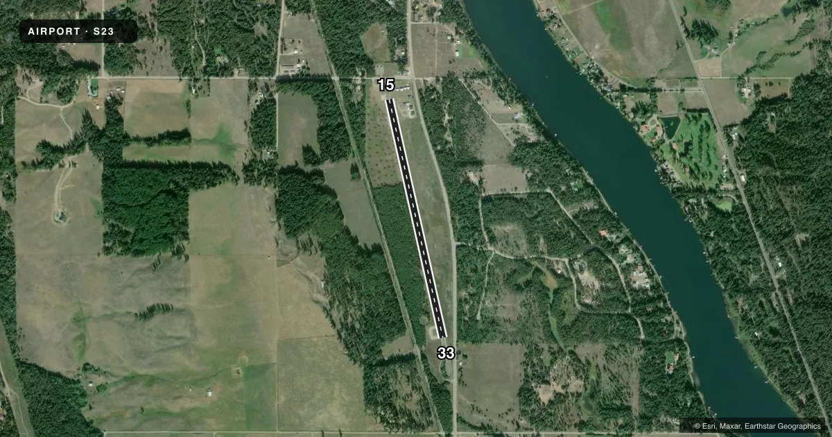
Runways & pattern
Full pagePattern entry · RWY 15
LEFT TRAFFICRunway end performance
| End | TORA | TODA | ASDA | LDA | VGSI | Approach lights | Obstruction |
|---|---|---|---|---|---|---|---|
| 15 | 3,421' | 3,421' | 3,421' | 3,421' | — | — | 8', fence, 210' from thr, 0' R of cntrln, slope 1 |
| 33 | 3,644' | 3,644' | 3,644' | 3,421' | — | — | — |
Declared distances in feet. TORA = takeoff run available, TODA = takeoff distance, ASDA = accelerate-stop, LDA = landing distance.
Airport sketch
Runways drawn to scale from FAA survey coordinates, rendered over satellite imagery. Not for navigation.
Approaches & charts
Services on the field
Fuel grades, oxygen, maintenance, ramp storage and lighting — as declared to the FAA by the airport operator.
Fuel & services
- Fuel
- Not available
- Oxygen (bottled)
- Not available
- Oxygen (bulk)
- Not available
- Airframe repair
- Not available
- Power plant repair
- Not available
Ramp & ground
- Transient storage
- Tie-down
- Landing fee
- No fee published
- Customs
- Not available
- Lighting schedule
- SS-SR
- Beacon schedule
- SS-SR
- Beacon
- White / Green (civil land)(WG)
- Wind indicator
- Lighted
- Segmented circle
- No
Fuel & FBOs
Cheapest 100LL and Jet A on the field and nearby. Always confirm with the FBO before taxi.
Airport notes
Surface conditions, obstructions, local procedures, lighting outages and other notes published with each FAA cycle.
General notes
- WILDLIFE INVOF RY.
- ARPT USED FOR SEASONAL WILDLAND FIRE SPT
- FOR CD CTC SEATTLE ARTCC AT 253-351-3694.
Approach & departure obstructions
- 15RWY 15/33 MARKINGS ARE FADED.
- H1H1 MARKINGS ARE FADED.
Other notes
- ESTABD PRIOR TO 15 MAY 1959.
- TIEDOWNS PILOT PROVIDED
VFR map & nearby airports
VFR sectional. Tap any ICAO chip to open that airport.
Key facts · S23
Answer card- ICAO
- S23
- Name
- IONE MUNI
- Location
- IONE, WASHINGTON
- Elevation
- 2,109.5 ft MSL
- Traffic pattern altitude
- 3,109.5 ft MSL (1,000 AGL)
- Control tower
- Non-towered (use CTAF)
- Total runways
- 1
- Longest runway
- 15/33 · 3,643 ft
- Published ILS approaches
- 0
- Published frequencies
- 1
- Magnetic variation
- 20°
- Current flight rules
- VFR
- Current wind
- 150° at 9 kt
- Favored runway now
- RWY 15
Ione Muni (S23) sits in Ione, Washington. The field elevation is 2,109.5 ft MSL. It has one runway, 15/33, which is 3,643 ft long and asphalt. The airport is not towered. CTAF is 122.9. No ILS approaches are published here.
The pattern altitude is not published. Use the standard 1,000 ft AGL pattern unless the current Chart Supplement says otherwise. That puts the light-piston pattern at about 3,109.5 ft MSL based on the field elevation. Verify before you fly. Magnetic variation is 20°. Runway headings in the facts are magnetic.
Published remarks matter here. Seattle ARTCC handles clearance delivery by phone. The airport is used for seasonal wildland fire support. Wildlife is in the vicinity of the runway. Runway 15/33 markings are faded. Heliport H1 markings are also faded. Tiedowns are pilot provided. There are no on-field FBOs listed, so plan on bringing what you need and contact the airport operator or the field directly for current services before arrival. The field sits in a higher-elevation part of Washington, so performance planning should account for density altitude, runway length and local terrain. Check the current Chart Supplement for any noise or curfew restrictions before flying in.