METAR & TAF 65S
Current METAR
Observed 17:15Z
K65S 271715Z AUTO 18007KT 140V230 10SM CLR 25/05 A3004 RMK AO2
- Wind
- 180° @ 7 kt
- Visibility
- 10 SM
- Temp / Dew
- 25°C / 5°C
- Altimeter
- 30.04 inHg
- Clouds
- CLR
- Density alt
- 3,949 ft
- Ceiling
- Unlimited
- Rules
- VFR
Airport info & contacts
Manager on record, flight service, ARTCC, attendance schedule and pattern altitude — published by the FAA and refreshed every 28 days.
Location
- From city
- 2 NM NE
- VFR sectional
- GREAT FALLS
- ARTCC
- ZSE · SEATTLE
- NOTAM facility
- BOI (NOTAM-D)
Airport manager
- Name
- DAVE PARKER
- Phone
- 208-267-3711
- Address
- 64602 HIGHWAY 2, BONNERS FERRY ID 83805
Flight service · Hours
- FSS BOI
- BOISE1-800-WX-BRIEF
- Attendance
- MON-FRI · 0800-1700
- SAT · 0800-1600
Frequencies
Tap any row to copy the frequency to your clipboard.
Runways & pattern
Full pagePattern entry · RWY 20
LEFT TRAFFICRunway end performance
| End | TORA | TODA | ASDA | LDA | VGSI | Approach lights | Obstruction |
|---|---|---|---|---|---|---|---|
| 02 | — | — | — | — | PAPI 2-box left(3.5°) | — | — |
| 20 | — | — | — | — | — | — | 7', fence, 200' from thr, 240' R of cntrln, slope 0 |
Declared distances in feet. TORA = takeoff run available, TODA = takeoff distance, ASDA = accelerate-stop, LDA = landing distance.
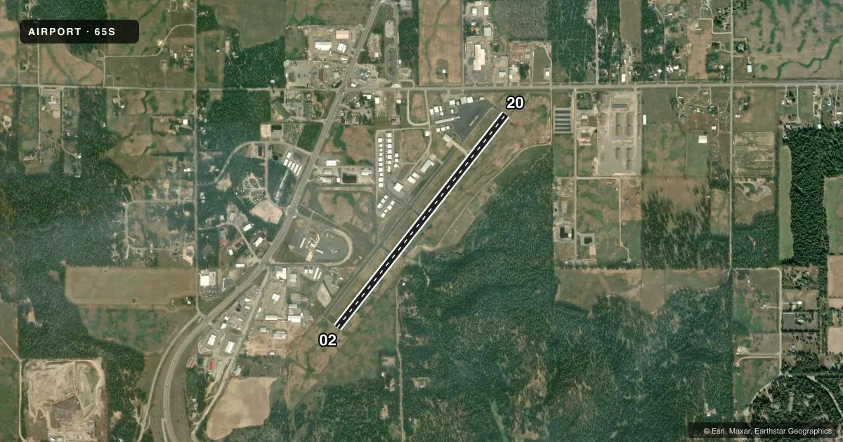
Airport sketch
Runways drawn to scale from FAA survey coordinates, rendered over satellite imagery. Not for navigation.
Approaches & charts
Services on the field
Fuel grades, oxygen, maintenance, ramp storage and lighting — as declared to the FAA by the airport operator.
Fuel & services
- Fuel
- 100LLA
- Oxygen (bottled)
- Low pressure
- Oxygen (bulk)
- Not available
- Airframe repair
- Major
- Power plant repair
- Minor
- Other services
- CHTR,INSTR,RNTL,SALES
Ramp & ground
- Transient storage
- Tie-down
- Hangar
- Landing fee
- No fee published
- Customs
- Not available
- Lighting schedule
- SEE RMK
- Beacon schedule
- SS-SR
- Beacon
- White / Green (civil land)(WG)
- Wind indicator
- Lighted
- Segmented circle
- Yes
Fuel & FBOs
Cheapest 100LL and Jet A on the field and nearby. Always confirm with the FBO before taxi.
Airport notes
Surface conditions, obstructions, local procedures, lighting outages and other notes published with each FAA cycle.
General notes
- COLD TEMPERATURE AIRPORT. ALTITUDE CORRECTION REQUIRED AT OR BELOW -6C.
- FOR CD CTC SEATTLE ARTCC AT 253-351-3694.
Lighting notes
- ACTVT MIRL RWY 02/20 - CTAF; PAPI RWY 02 OPR CONSLY.
Approach & departure obstructions
- 02+85 FT TREES AT 800 FT 375 FT L.
- 20+85 FT TREES AT 1200 FT 300 FT L; +75 FT TREES AT 1600 FT ON CNTRLN.
VFR map & nearby airports
VFR sectional. Tap any ICAO chip to open that airport.
Key facts · 65S
Answer card- ICAO
- 65S
- Name
- BOUNDARY COUNTY
- Location
- BONNERS FERRY, IDAHO
- Elevation
- 2,337.1 ft MSL
- Traffic pattern altitude
- 3,337.1 ft MSL (1,000 AGL)
- Control tower
- Non-towered (use CTAF)
- Total runways
- 1
- Longest runway
- 02/20 · 4,002 ft
- Published ILS approaches
- 0
- Published frequencies
- 2
- Magnetic variation
- 16°
- Current flight rules
- VFR
- Current wind
- 180° at 7 kt
- Favored runway now
- RWY 20
Boundary County Airport sits in Bonners Ferry, Idaho. Field elevation is 2,337.1 ft MSL. The airport has one runway, 02/20, which is 4,002 ft long and asphalt. There is no control tower. CTAF and UNICOM are both 123.0. No ILS approaches are published here.
The published pattern altitude is not listed. Use the standard 1,000 ft AGL for light piston operations unless the current FAA Chart Supplement says otherwise. Northern Air is on the field. It carries AVGAS 100LL and JET A. Call (208) 267-4359 for current fuel and ramp details.
This is a cold temperature airport. Altitude correction is required at or below minus 6 degrees Celsius. That matters here because the field already sits above 2,300 ft MSL. Trees are also published near both runway ends. Expect to pay attention to departure and landing performance, especially on shorter winter days or when density altitude climbs. Runway lights on 02/20 are medium intensity and are activated by CTAF. The PAPI for runway 02 operates continuously. For clearance delivery, contact Seattle ARTCC at 253-351-3694.