METAR & TAF 67S
67S does not publish a METAR.
Showing the nearest reporting station: KSZT (SANDPOINT) · 22.9 NM away. Conditions at 67S may differ.
METAR · KSZT
Observed 17:15Z
KSZT 271715Z AUTO 15009KT 10SM CLR 25/05 A3006 RMK AO2
- Wind
- 150° @ 9 kt
- Visibility
- 10 SM
- Temp / Dew
- 25°C / 5°C
- Altimeter
- 30.06 inHg
- Clouds
- CLR
- Density alt
- 4,264 ft
- Ceiling
- Unlimited
- Rules
- VFR
Airport info & contacts
Manager on record, flight service, ARTCC, attendance schedule and pattern altitude — published by the FAA and refreshed every 28 days.
Location
- From city
- 3 NM S
- VFR sectional
- GREAT FALLS
- ARTCC
- ZSE · SEATTLE
- NOTAM facility
- BOI (NOTAM-D)
Airport manager
- Name
- JAMES GRASHAM - AVIATION OFFICER
- Phone
- 208-762-6926
- Address
- 11569 AIRPORT DR, HAYDEN ID 83835
Flight service · Hours
- FSS BOI
- BOISE1-800-WX-BRIEF
- Attendance
- Unattended
Frequencies
Tap any row to copy the frequency to your clipboard.
Runways & pattern
Full pagePattern entry · RWY 14
LEFT TRAFFICRunway end performance
| End | TORA | TODA | ASDA | LDA | VGSI | Approach lights | Obstruction |
|---|---|---|---|---|---|---|---|
| 14 | — | — | — | — | — | — | 80', trees, 0' from thr, 150' R of cntrln, slope 0 |
| 32 | — | — | — | — | — | — | 95', tree, 275' from thr, 100' R of cntrln, slope 2 |
Declared distances in feet. TORA = takeoff run available, TODA = takeoff distance, ASDA = accelerate-stop, LDA = landing distance.
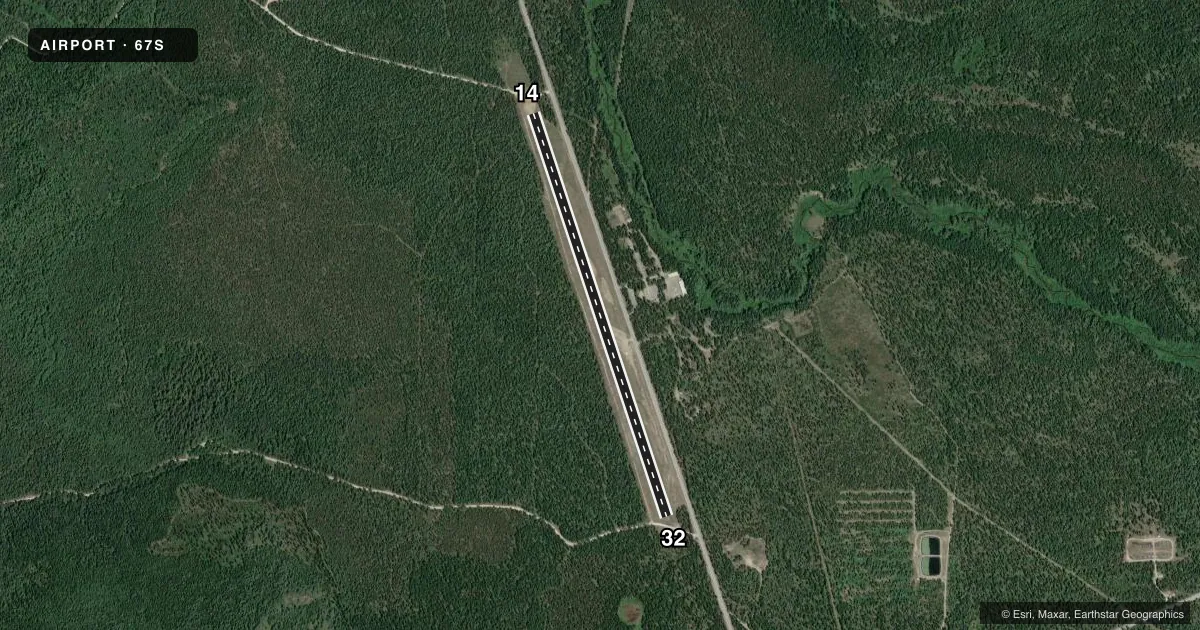
Airport sketch
Runways drawn to scale from FAA survey coordinates, rendered over satellite imagery. Not for navigation.
Approaches & charts
Services on the field
Fuel grades, oxygen, maintenance, ramp storage and lighting — as declared to the FAA by the airport operator.
Fuel & services
- Fuel
- Not available
- Airframe repair
- Not available
- Power plant repair
- Not available
Ramp & ground
- Transient storage
- Tie-down
- Landing fee
- No fee published
- Wind indicator
- Yes
- Segmented circle
- No
Fuel & FBOs
Cheapest 100LL and Jet A on the field and nearby. Always confirm with the FBO before taxi.
Airport notes
Surface conditions, obstructions, local procedures, lighting outages and other notes published with each FAA cycle.
General notes
- NO WINTER MAINT.
- DO NOT PARK ACFT WI 100 FT OF WX STN.
- USFS HELIPAD PVT USE - LCTD ON ARPT.
- FOR CD CTC SEATTLE ARTCC AT 253-351-3694.
Runway surface & condition
- 14/32MAY NOT BE MOWED TO FULL WIDTH.
Approach & departure obstructions
- 14RWY 14/32 IS MKD ONLY WITH W CEMENT BDRY MKRS; THLDS MKD WITH CONC STRIPS.
- 14AIRFIELD IS SRNDD BY 70-80 FT TALL TREES.
- 1460 FT TREES AT 950 FT ON CNTRLN.
- 3214 FT ROAD 300 FT ON CNTRLN; 60 FT TREES 500 FT TO 1000 FT ON CNTRLN.
Other notes
- ARPT EXISTED PRIOR TO 15 MAY 59.
VFR map & nearby airports
VFR sectional. Tap any ICAO chip to open that airport.
Key facts · 67S
Answer card- ICAO
- 67S
- Name
- PRIEST LAKE USFS
- Location
- NORDMAN, IDAHO
- Elevation
- 2,611 ft MSL
- Traffic pattern altitude
- 3,611 ft MSL (1,000 AGL)
- Control tower
- Non-towered (use CTAF)
- Total runways
- 1
- Longest runway
- 14/32 · 4,400 ft
- Published ILS approaches
- 0
- Published frequencies
- 1
- Magnetic variation
- 20°
- Current flight rules
- VFR
- Current wind
- 150° at 9 kt
- Favored runway now
- RWY 14
Priest Lake USFS sits near Nordman, Idaho at 2,611 ft MSL. It has one runway, 14/32, which is 4,400 ft long with a turf-gravel surface. The field is non-towered. CTAF is 122.9. No ILS approaches are published here.
Pattern altitude is not published. Use the standard 1,000 ft AGL pattern unless the current Chart Supplement says otherwise. The runway is marked with white cement boundary markers. Thresholds are marked with concrete strips. Runway 14/32 may not be mowed to full width. The airfield is surrounded by 70 to 80 ft trees, so expect a tight visual environment on both ends. There are also 60 ft trees on the centerline near runway 14. On runway 32, watch for a 14 ft road 300 ft out on centerline, plus 60 ft trees farther down the centerline.
No on-field FBOs are listed. If you need services, contact the airport operator or the FBO directly by phone before arrival. Do not park within 100 ft of the weather station. The USFS helipad on the field is private use. There is no winter maintenance, so surface condition is a real planning item in cold weather. For clearance delivery, contact Seattle ARTCC at 253-351-3694.