METAR & TAF 66S
66S does not publish a METAR.
Showing the nearest reporting station: KSZT (SANDPOINT) · 16.8 NM away. Conditions at 66S may differ.
METAR · KSZT
Observed 17:15Z
KSZT 271715Z AUTO 15009KT 10SM CLR 25/05 A3006 RMK AO2
- Wind
- 150° @ 9 kt
- Visibility
- 10 SM
- Temp / Dew
- 25°C / 5°C
- Altimeter
- 30.06 inHg
- Clouds
- CLR
- Density alt
- 4,107 ft
- Ceiling
- Unlimited
- Rules
- VFR
Airport info & contacts
Manager on record, flight service, ARTCC, attendance schedule and pattern altitude — published by the FAA and refreshed every 28 days.
Location
- From city
- 3 NM N
- VFR sectional
- GREAT FALLS
- ARTCC
- ZSE · SEATTLE
- NOTAM facility
- BOI (NOTAM-D)
Airport manager
- Name
- DIVISION ADMIN
- Phone
- 208-334-8775
- Address
- BOX 7129, BOISE ID 83707-1129
Flight service · Hours
- FSS BOI
- BOISE1-800-WX-BRIEF
- Attendance
- JUN-AUG · THU-MON · 0800-1700
Frequencies
Tap any row to copy the frequency to your clipboard.
Runways & pattern
Full pagePattern entry · RWY 15
RIGHT TRAFFICRunway end performance
| End | TORA | TODA | ASDA | LDA | VGSI | Approach lights | Obstruction |
|---|---|---|---|---|---|---|---|
| 15 | — | — | — | — | — | — | 85', tree, 0' from thr, 90' R of cntrln, slope 0 |
| 33 | — | — | — | — | — | — | 65', tree, 0' from thr, 95' R of cntrln, slope 0 |
Declared distances in feet. TORA = takeoff run available, TODA = takeoff distance, ASDA = accelerate-stop, LDA = landing distance.
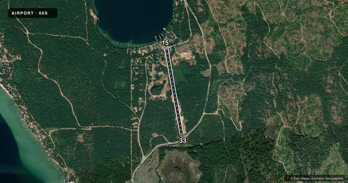
Airport sketch
Runways drawn to scale from FAA survey coordinates, rendered over satellite imagery. Not for navigation.
Approaches & charts
Services on the field
Fuel grades, oxygen, maintenance, ramp storage and lighting — as declared to the FAA by the airport operator.
Fuel & services
- Fuel
- Not available
- Airframe repair
- Not available
- Power plant repair
- Not available
Ramp & ground
- Transient storage
- Tie-down
- Landing fee
- No fee published
- Wind indicator
- Yes
- Segmented circle
- Yes
Fuel & FBOs
Cheapest 100LL and Jet A on the field and nearby. Always confirm with the FBO before taxi.
Airport notes
Surface conditions, obstructions, local procedures, lighting outages and other notes published with each FAA cycle.
General notes
- NO WINTER MAINTENANCE.
- RWY 15/33 NO LINE OF SIGHT BTN RWY ENDS.
- WATCH FOR SPRINKLERS ON RY.
- ARPT ATTENDED BY CARETAKER DURG SUMMER MONTHS.
- SEAPLANE OPERATIONS CONDUCTED IN BAY NORTH & ADJACENT TO ARPT; MONITOR CTAF.
- HEAVY SNOWMOBILES ACTIVITY DURING WINTER MONTHS.
- FOR CD CTC SEATTLE ARTCC AT 253-351-3694.
Approach & departure obstructions
- 1515/33 EDGES & THRS MKD WITH WHITE ROCKS.
- 15BOTH RWY ENDS HAVE 50-70 FT TALL TREES. AFCTS EITHER APCH OR DEP.
- 15RY 15 +100 FT TREE 310 FT FM RY END 150 FT R; +12 FT ROAD 40 FT ON CNTRLN; +120 FT TREE 200 FT FM RY END 180 FT L; +30 FT TREE 125 FT FM RY END ON CNTRLN; +25 FT BLDG AT 90 FT; 60 FT L.
Other notes
- ARPT EXISTED PRIOR TO 15 MAY 59.
VFR map & nearby airports
VFR sectional. Tap any ICAO chip to open that airport.
Key facts · 66S
Answer card- ICAO
- 66S
- Name
- CAVANAUGH BAY
- Location
- COOLIN, IDAHO
- Elevation
- 2,484 ft MSL
- Traffic pattern altitude
- 3,484 ft MSL (1,000 AGL)
- Control tower
- Non-towered (use CTAF)
- Total runways
- 1
- Longest runway
- 15/33 · 3,100 ft
- Published ILS approaches
- 0
- Published frequencies
- 1
- Magnetic variation
- 20°
- Current flight rules
- VFR
- Current wind
- 150° at 9 kt
- Favored runway now
- RWY 15
Cavanaugh Bay Airport sits in Coolin, Idaho. The field elevation is 2,484 ft MSL. It has one runway, 15/33. The longest runway is 3,100 ft of turf. This is an uncontrolled field with no tower. CTAF is 122.9.
No ILS approaches are published here. The pattern altitude is not published, so use standard light piston pattern planning at 1,000 ft AGL unless the current Chart Supplement says otherwise. The airport has a magnetic variation of 20°. Runway 15/33 uses white rocks to mark the edges and thresholds. The runway ends do not have line of sight to each other.
This is a field where you want to brief the terrain and the runway environment before arrival. Both runway ends have trees that affect approach or departure. Runway 15 has several close-in obstacles near the threshold area, including trees, a road and a building. Sprinklers can be on the runway. No winter maintenance is provided. Heavy snowmobile activity also occurs in winter. Seaplane operations are conducted in the bay north and adjacent to the airport. Monitor CTAF for that traffic. A caretaker is on site during summer months. For clearance delivery, contact Seattle ARTCC at 253-351-3694.