METAR & TAF KSZT
Current METAR
Observed 13:15Z
KSZT 271315Z AUTO 00000KT 10SM CLR 10/06 A3005 RMK AO2
- Wind
- 000° @ 0 kt
- Visibility
- 10 SM
- Temp / Dew
- 10°C / 6°C
- Altimeter
- 30.05 inHg
- Clouds
- CLR
- Density alt
- 1,881 ft
- Ceiling
- Unlimited
- Rules
- VFR
Airport info & contacts
Manager on record, flight service, ARTCC, attendance schedule and pattern altitude — published by the FAA and refreshed every 28 days.
Location
- From city
- 2 NM N
- VFR sectional
- GREAT FALLS
- ARTCC
- ZSE · SEATTLE
- NOTAM facility
- SZT (NOTAM-D)
Airport manager
- Name
- DAVE SCHUCK
- Phone
- 208-265-2266
- Address
- 1500 HWY 2 SUITE 308, SANDPOINT ID 83864
Flight service · Hours
- FSS BOI
- BOISE1-800-WX-BRIEF
- Attendance
- SUMMER · 0700-1700
- WINTER · 0800-1700
Frequencies
Tap any row to copy the frequency to your clipboard.
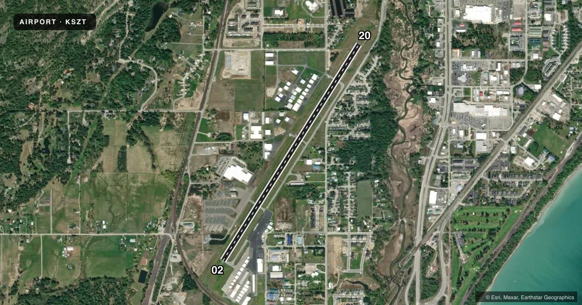
Runways & pattern
Full pagePattern entry · RWY 02
LEFT TRAFFICRunway end performance
| End | TORA | TODA | ASDA | LDA | VGSI | Approach lights | Obstruction |
|---|---|---|---|---|---|---|---|
| 02 | — | — | — | — | PAPI 2-box left(3.75°) | — | 60', trees, 850' from thr, 100' R of cntrln, slope 10 |
| 20 | — | — | — | — | PAPI 2-box left(3.75°) | — | 90', trees, 610' from thr, 280' R of cntrln, slope 4 |
Declared distances in feet. TORA = takeoff run available, TODA = takeoff distance, ASDA = accelerate-stop, LDA = landing distance.
Airport sketch
Runways drawn to scale from FAA survey coordinates, rendered over satellite imagery. Not for navigation.
Approaches & charts
ILS · 1
Services on the field
Fuel grades, oxygen, maintenance, ramp storage and lighting — as declared to the FAA by the airport operator.
Fuel & services
- Fuel
- 100LLA
- Oxygen (bottled)
- HIGH/LOW
- Oxygen (bulk)
- Not available
- Airframe repair
- Major
- Power plant repair
- Major
- Other services
- CHTR,INSTR,RNTL
Ramp & ground
- Transient storage
- Tie-down
- Hangar
- Landing fee
- No fee published
- Customs
- Not available
- Lighting schedule
- SEE RMK
- Beacon schedule
- SS-SR
- Beacon
- White / Green (civil land)(WG)
- Wind indicator
- Lighted
- Segmented circle
- Yes
Fuel & FBOs
Cheapest 100LL and Jet A on the field and nearby. Always confirm with the FBO before taxi.
Airport notes
Surface conditions, obstructions, local procedures, lighting outages and other notes published with each FAA cycle.
General notes
- ADDNL OBSTN 23 FT RR AT 740 FT ON CNTRLN, 85 FT TREES AT 2650 FT ON CNTRLN.
- WILDLIFE INVOF ARPT.
- FOR CD CTC SEATTLE ARTCC AT 253-351-3694.
- COLD TEMPERATURE AIRPORT. ALTITUDE CORRECTION REQUIRED AT OR BELOW -16C.
Lighting notes
- ACTVT REIL RWY 02 & 20; MIRL 02/20 - CTAF. PAPI RWY 02 & 20 OPR CONSLY.
Other notes
- ESTABD PRIOR TO 15 MAY 59.
VFR map & nearby airports
VFR sectional. Tap any ICAO chip to open that airport.
Key facts · KSZT
Answer card- ICAO
- KSZT
- Name
- SANDPOINT
- Location
- SANDPOINT, IDAHO
- Elevation
- 2,131 ft MSL
- Traffic pattern altitude
- 3,131 ft MSL (1,000 AGL)
- Control tower
- Non-towered (use CTAF)
- Total runways
- 1
- Longest runway
- 02/20 · 5,501 ft
- Published ILS approaches
- 1
- Published frequencies
- 2
- Magnetic variation
- 14°
- Current flight rules
- VFR
- Current wind
- 000° at 0 kt
- Favored runway now
- –
Sandpoint Airport sits in Sandpoint, Idaho. The field elevation is 2,131 ft MSL. It has one runway. Runway 02/20 is 5,501 ft long with asphalt pavement. There is no control tower. CTAF and UNICOM are both 122.7.
The airport has one ILS approach to runway 02. Pattern altitude is not published in the facts, so use the standard 1,000 ft AGL for light piston traffic unless the current FAA Chart Supplement says otherwise. Granite Aviation is on the field. It carries 100LL and Jet A. Call them at (208) 263-9102 for current services.
A few remarks matter here. This is a cold temperature airport, so altitude correction is required at or below minus 16 degrees Celsius. Wildlife is reported in the area. There are also published obstructions on final. One is a 23-foot railroad on the centerline 740 feet from the runway. Another is 85-foot trees on the centerline 2,650 feet out. Runway lights on 02 and 20 are CTAF-controlled. PAPI on both ends operates continuously. For clearance delivery, contact Seattle ARTCC at 253-351-3694. Expect a non-towered mountain-area arrival with density altitude and terrain considerations in the mix, especially when the weather is warm or the field is busy.