METAR & TAF 1S1
1S1 does not publish a METAR.
Showing the nearest reporting station: KSZT (SANDPOINT) · 41.5 NM away. Conditions at 1S1 may differ.
METAR · KSZT
Observed 13:15Z
KSZT 271315Z AUTO 00000KT 10SM CLR 10/06 A3005 RMK AO2
- Wind
- 000° @ 0 kt
- Visibility
- 10 SM
- Temp / Dew
- 10°C / 6°C
- Altimeter
- 30.05 inHg
- Clouds
- CLR
- Density alt
- 1,419 ft
- Ceiling
- Unlimited
- Rules
- VFR
Airport info & contacts
Manager on record, flight service, ARTCC, attendance schedule and pattern altitude — published by the FAA and refreshed every 28 days.
Location
- From city
- 0 NM W
- VFR sectional
- GREAT FALLS
- ARTCC
- ZSE · SEATTLE
- NOTAM facility
- BOI (NOTAM-D)
Airport manager
- Name
- DIVISION ADMIN
- Phone
- 208-334-8775
- Address
- BOX 7129, BOISE ID 83707-1129
Flight service · Hours
- FSS BOI
- BOISE1-800-WX-BRIEF
- Attendance
- Unattended
Frequencies
Tap any row to copy the frequency to your clipboard.
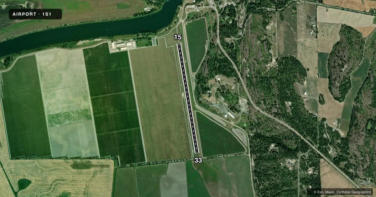
Runways & pattern
Full pagePattern entry · RWY 15
LEFT TRAFFICRunway end performance
| End | TORA | TODA | ASDA | LDA | VGSI | Approach lights | Obstruction |
|---|---|---|---|---|---|---|---|
| 15 | — | — | — | — | — | — | 75', trees, 675' from thr, 0' R of cntrln, slope 9 |
| 33 | — | — | — | — | — | — | 16', road, 300' from thr, 0' R of cntrln, slope 18 |
Declared distances in feet. TORA = takeoff run available, TODA = takeoff distance, ASDA = accelerate-stop, LDA = landing distance.
Airport sketch
Runways drawn to scale from FAA survey coordinates, rendered over satellite imagery. Not for navigation.
Approaches & charts
Services on the field
Fuel grades, oxygen, maintenance, ramp storage and lighting — as declared to the FAA by the airport operator.
Fuel & services
- Fuel
- Not available
- Oxygen (bottled)
- Not available
- Oxygen (bulk)
- Not available
- Airframe repair
- Not available
- Power plant repair
- Not available
Ramp & ground
- Transient storage
- Tie-down
- Landing fee
- No fee published
- Customs
- Not available
- Wind indicator
- Yes
- Segmented circle
- Yes
Fuel & FBOs
Cheapest 100LL and Jet A on the field and nearby. Always confirm with the FBO before taxi.
Airport notes
Surface conditions, obstructions, local procedures, lighting outages and other notes published with each FAA cycle.
General notes
- NO WINTER MAINTENANCE.
- ACFT PRKG LTD TO TWO HRS IN CUST TRML AREA; LONGER TERM PRKG AVBL TO THE WEST OF RWY END 15 - BTN ASPH TWY & ANHEUSER-BUSCH PLANT.
- RWY 15 DO NOT USE ASPH TWY PTN FOR TKOF.
- +25' HOP POLES LOCATED ADJACENT TO BOTH SIDES OF RWY.
- (E84) NON STD - SEMI CIRCLE.
- FOR CD CTC SEATTLE ARTCC AT 253-351-3694.
Runway surface & condition
- 15/33RCMD LAND RWY 33; TKOF RWY 15 WHEN WIND COND PERMITS.
Approach & departure obstructions
- 1515/33 EDGES AND THRS MARKED WITH WHITE ROCKS.
- 15NMRS OBSTNS IN APCH TO RWY 15: 50 FT - 75 FT + TREES AT 675 FT ON CNTRLN; 40 FT PWR LINE AT 1200 FT ON CNTRLN.
Other notes
- 1/2 SEGMENTED CIRCLE.
VFR map & nearby airports
VFR sectional. Tap any ICAO chip to open that airport.
Key facts · 1S1
Answer card- ICAO
- 1S1
- Name
- ECKHART INTL
- Location
- PORTHILL, IDAHO
- Elevation
- 1,758 ft MSL
- Traffic pattern altitude
- 2,758 ft MSL (1,000 AGL)
- Control tower
- Non-towered (use CTAF)
- Total runways
- 1
- Longest runway
- 15/33 · 3,650 ft
- Published ILS approaches
- 0
- Published frequencies
- 2
- Magnetic variation
- 20°
- Current flight rules
- VFR
- Current wind
- 000° at 0 kt
- Favored runway now
- –
ECKHART INTL is in Porthill, Idaho. The field elevation is 1,758 ft MSL. It has one runway. Runway 15/33 is 3,650 ft long and turf. This is an uncontrolled airport with CTAF and UNICOM both on 122.8. No ILS approaches are published. The pattern altitude is not published, so use the standard 1,000 ft AGL for light piston operations unless the current Chart Supplement says otherwise.
There are no on-field FBOs listed here. Plan on self-sufficiency for fuel and services. Check with the airport operator or the FBO directly by phone before you go. Published remarks matter here. There is no winter maintenance. Parking in the customer terminal area is limited to two hours. Longer term parking is west of runway end 15 between the asphalt taxiway and the Anheuser-Busch plant. Do not use the asphalt taxiway portion for takeoff on runway 15.
Runway 33 is the recommended landing runway. Use runway 15 for takeoff when wind conditions permit. The approach to runway 15 has several obstructions. Expect trees and other obstacles on final. There are also 25-foot hop poles next to both sides of the runway. The field uses a non standard semicircle. For clearance delivery, contact Seattle ARTCC at 253-351-3694. Check the current FAA Chart Supplement before flight for the latest remarks and any local operating notes.