METAR & TAF KTHM
KTHM does not publish a METAR.
Showing the nearest reporting station: KGPI (GLACIER PARK INTL) · 60.5 NM away. Conditions at KTHM may differ.
METAR · KGPI
Observed 03:55Z
KGPI 270355Z 26005KT 10SM CLR 20/00 A2998 RMK AO2 SLP139 T02000000
- Wind
- 260° @ 5 kt
- Visibility
- 10 SM
- Temp / Dew
- 20°C / 0°C
- Altimeter
- 29.98 inHg
- Clouds
- CLR
- Density alt
- 3,585 ft
- Ceiling
- Unlimited
- Rules
- VFR
Airport info & contacts
Manager on record, flight service, ARTCC, attendance schedule and pattern altitude — published by the FAA and refreshed every 28 days.
Location
- From city
- 3 NM SE
- VFR sectional
- GREAT FALLS
- ARTCC
- ZSE · SEATTLE
- NOTAM facility
- GTF (NOTAM-D)
Airport manager
- Name
- KIM ROBERTS
- Phone
- 406-827-3519
- Address
- P.O. BOX 1204, THOMPSON FALLS MT 59873
Flight service · Hours
- FSS GTF
- GREAT FALLS1-800-WX-BRIEF
- Attendance
- Unattended
Frequencies
Tap any row to copy the frequency to your clipboard.
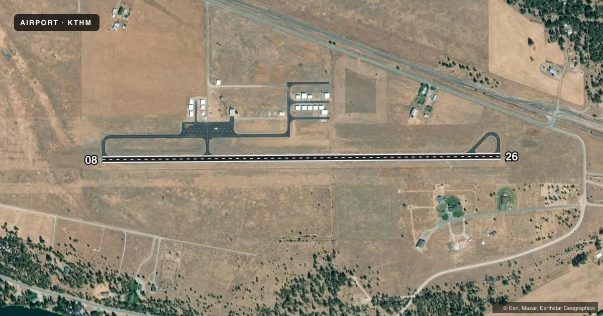
Runways & pattern
Full pagePattern entry · RWY 26
LEFT TRAFFICRunway end performance
| End | TORA | TODA | ASDA | LDA | VGSI | Approach lights | Obstruction |
|---|---|---|---|---|---|---|---|
| 08 | — | — | — | — | PAPI 2-box left(3°) | — | — |
| 26 | — | — | — | — | PAPI 2-box left(3.25°) | — | 104', trees, 1900' from thr, 0' R of cntrln, slope 16 |
Declared distances in feet. TORA = takeoff run available, TODA = takeoff distance, ASDA = accelerate-stop, LDA = landing distance.
Airport sketch
Runways drawn to scale from FAA survey coordinates, rendered over satellite imagery. Not for navigation.
Approaches & charts
Services on the field
Fuel grades, oxygen, maintenance, ramp storage and lighting — as declared to the FAA by the airport operator.
Fuel & services
- Fuel
- 100LL
- Oxygen (bottled)
- Not available
- Oxygen (bulk)
- Not available
- Airframe repair
- Not available
- Power plant repair
- Not available
Ramp & ground
- Transient storage
- Tie-down
- Landing fee
- No fee published
- Customs
- Not available
- Lighting schedule
- SEE RMK
- Beacon schedule
- SS-SR
- Beacon
- White / Green (civil land)(WG)
- Wind indicator
- Lighted
- Segmented circle
- Yes
Fuel & FBOs
Cheapest 100LL and Jet A on the field and nearby. Always confirm with the FBO before taxi.
Airport notes
Surface conditions, obstructions, local procedures, lighting outages and other notes published with each FAA cycle.
General notes
- MKD PWR LINES 7 MI E MAINLAND TO BIG IS.
- PHONE ON ARPT.
- 100 FT SILO IN TRANS SFC NE SIDE OF RY.
- WATERFOWL INVOF ARPT.
- 300 FT CANDLESTICK FXD DIST MKRS IN TRANS SFC.
- SN REMOVAL INTMT. CALL 406-546-6384 FOR RWY COND.
- FOR CD CTC SEATTLE ARTCC AT 253-351-3694.
Lighting notes
- ACTVT PAPI RWY 8 & 26; MIRL RWY 08/26 - CTAF.
Fuel notes
- 100LLFUEL AVBL 24/7 WITH CREDIT CARD.
Other notes
- CONSTR PRIOR 1959
- AUTOMATED UNICOM AVBL ON 118.325; 3 CLICKS.
- MANAGERALTN PHONE 406-546-6384 OR 406-598-6227.
VFR map & nearby airports
VFR sectional. Tap any ICAO chip to open that airport.
Key facts · KTHM
Answer card- ICAO
- KTHM
- Name
- THOMPSON FALLS
- Location
- THOMPSON FALLS, MONTANA
- Elevation
- 2,467.1 ft MSL
- Traffic pattern altitude
- 3,467.1 ft MSL (1,000 AGL)
- Control tower
- Non-towered (use CTAF)
- Total runways
- 1
- Longest runway
- 08/26 · 4,200 ft
- Published ILS approaches
- 0
- Published frequencies
- 1
- Magnetic variation
- 19°
- Current flight rules
- VFR
- Current wind
- 260° at 5 kt
- Favored runway now
- RWY 26
Thompson Falls Airport sits in Thompson Falls, Montana. Field elevation is 2,467.1 ft MSL. The airport has one runway, 08/26, which is 4,200 ft long and asphalt. There is no control tower. CTAF is 122.9. Automated UNICOM is available on 118.325 with three clicks. No ILS approaches are published here.
Pattern altitude is not published. Use the standard 1,000 ft AGL pattern for light piston aircraft unless the current Chart Supplement or local procedures say otherwise. The field carries 100LL with 24-hour self-serve credit card access. There is no on-field FBO listed in the facts, so verify services with the airport operator or by calling the field before arrival.
For a first-time arrival, pay attention to the published obstructions in the transitional surface. There is a 100-foot silo on the northeast side of the runway. There are also 300-foot candlestick fixed distance markers in the transitional surface. Snow removal is intermittent, so runway condition should be checked before a winter trip. Waterfowl are also reported in the area. PAPI is available on runways 8 and 26. Medium intensity runway lights are on 08/26 and are controlled by CTAF.