METAR & TAF S34
Current METAR
Observed 13:35Z
KS34 271335Z AUTO 00000KT 10SM CLR 11/09 A3009 RMK AO2
- Wind
- 000° @ 0 kt
- Visibility
- 10 SM
- Temp / Dew
- 11°C / 9°C
- Altimeter
- 30.09 inHg
- Clouds
- CLR
- Density alt
- 2,368 ft
- Ceiling
- Unlimited
- Rules
- VFR
Airport info & contacts
Manager on record, flight service, ARTCC, attendance schedule and pattern altitude — published by the FAA and refreshed every 28 days.
Location
- From city
- 1 NM NW
- VFR sectional
- GREAT FALLS
- ARTCC
- ZLC · SALT LAKE CITY
- NOTAM facility
- GTF (NOTAM-D)
Airport manager
- Name
- RANDY GARRISON
- Phone
- 406-370-6179
- Address
- PO BOX 988, PLAINS MT 59859
Flight service · Hours
- FSS GTF
- GREAT FALLS1-800-WX-BRIEF
- Attendance
- Unattended
Frequencies
Tap any row to copy the frequency to your clipboard.
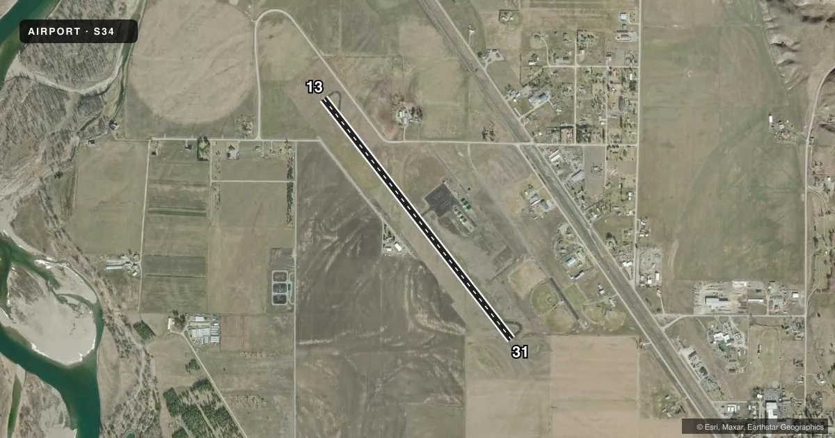
Runways & pattern
Full pagePattern entry · RWY 13
LEFT TRAFFICRunway end performance
| End | TORA | TODA | ASDA | LDA | VGSI | Approach lights | Obstruction |
|---|---|---|---|---|---|---|---|
| 31 | — | — | — | — | PAPI 2-box left(3°) | — | — |
Declared distances in feet. TORA = takeoff run available, TODA = takeoff distance, ASDA = accelerate-stop, LDA = landing distance.
Airport sketch
Runways drawn to scale from FAA survey coordinates, rendered over satellite imagery. Not for navigation.
Approaches & charts
Services on the field
Fuel grades, oxygen, maintenance, ramp storage and lighting — as declared to the FAA by the airport operator.
Fuel & services
- Fuel
- 100LLA
- Oxygen (bottled)
- Not available
- Oxygen (bulk)
- Not available
- Airframe repair
- Not available
- Power plant repair
- Not available
- Other services
- INSTR
Ramp & ground
- Transient storage
- Tie-down
- Landing fee
- No fee published
- Customs
- Not available
- Lighting schedule
- SEE RMK
- Beacon schedule
- SS-SR
- Beacon
- White / Green (civil land)(WG)
- Wind indicator
- Lighted
- Segmented circle
- Yes
Fuel & FBOs
Cheapest 100LL and Jet A on the field and nearby. Always confirm with the FBO before taxi.
Airport notes
Surface conditions, obstructions, local procedures, lighting outages and other notes published with each FAA cycle.
General notes
- FOR CD CTC SALT LAKE ARTCC AT 801-320-2568.
Lighting notes
- ACTVT PAPI RWY 31; MIRL RWY 13/31 - CTAF.
VFR map & nearby airports
VFR sectional. Tap any ICAO chip to open that airport.
Key facts · S34
Answer card- ICAO
- S34
- Name
- PLAINS
- Location
- PLAINS, MONTANA
- Elevation
- 2,467 ft MSL
- Traffic pattern altitude
- 3,467 ft MSL (1,000 AGL)
- Control tower
- Non-towered (use CTAF)
- Total runways
- 1
- Longest runway
- 13/31 · 4,650 ft
- Published ILS approaches
- 0
- Published frequencies
- 1
- Magnetic variation
- 18°
- Current flight rules
- VFR
- Current wind
- 000° at 0 kt
- Favored runway now
- –
Plains Airport sits in Plains, Montana. Field elevation is 2,467 ft MSL. The airport has one runway. Runway 13/31 is 4,650 ft long with an asphalt surface. There is no control tower. CTAF is 122.9. No ILS approaches are published here.
For pattern work, the published pattern altitude is not listed. Use the standard 1,000 ft AGL for light piston operations unless the current Chart Supplement says otherwise. The airport remarks matter on arrival. Runway 31 has an activated PAPI. Medium intensity runway lights are on runways 13 and 31. They are controlled by CTAF. For IFR clearance delivery, contact Salt Lake ARTCC at 801-320-2568.
This is a non-towered field at moderate elevation. Expect to plan for density altitude on warm days. The runway length is workable for light aircraft. Check the current Chart Supplement for any published noise or curfew restrictions before flying into the field. If you need fuel or ramp details, contact the airport operator directly before departure.