METAR & TAF S59
S59 does not publish a METAR.
Showing the nearest reporting station: KSZT (SANDPOINT) · 42.8 NM away. Conditions at S59 may differ.
METAR · KSZT
Observed 13:15Z
KSZT 271315Z AUTO 00000KT 10SM CLR 10/06 A3005 RMK AO2
- Wind
- 000° @ 0 kt
- Visibility
- 10 SM
- Temp / Dew
- 10°C / 6°C
- Altimeter
- 30.05 inHg
- Clouds
- CLR
- Density alt
- 2,469 ft
- Ceiling
- Unlimited
- Rules
- VFR
Airport info & contacts
Manager on record, flight service, ARTCC, attendance schedule and pattern altitude — published by the FAA and refreshed every 28 days.
Location
- From city
- 7 NM S
- VFR sectional
- GREAT FALLS
- ARTCC
- ZSE · SEATTLE
- NOTAM facility
- GTF (NOTAM-D)
Airport manager
- Name
- ROB FOX
- Phone
- (406) 334-0969
- Address
- 5136 FARM TO MARKET RD, LIBBY MT 59923-1655
Flight service · Hours
- FSS GTF
- GREAT FALLS1-800-WX-BRIEF
- Attendance
- ALL
Frequencies
Tap any row to copy the frequency to your clipboard.
Runways & pattern
Full pagePattern entry · RWY 15
LEFT TRAFFICRunway end performance
| End | TORA | TODA | ASDA | LDA | VGSI | Approach lights | Obstruction |
|---|---|---|---|---|---|---|---|
| 15 | — | — | — | — | PAPI 2-box left(3°) | — | 38', trees, 215' from thr, 170' R of cntrln, slope 0 |
| 33 | — | — | — | — | PAPI 2-box left(3.75°) | — | 23', trees, 392' from thr, 140' R of cntrln, slope 8 |
Declared distances in feet. TORA = takeoff run available, TODA = takeoff distance, ASDA = accelerate-stop, LDA = landing distance.
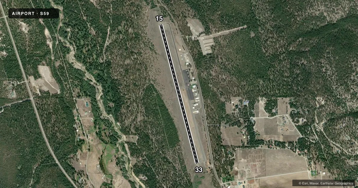
Airport sketch
Runways drawn to scale from FAA survey coordinates, rendered over satellite imagery. Not for navigation.
Approaches & charts
Services on the field
Fuel grades, oxygen, maintenance, ramp storage and lighting — as declared to the FAA by the airport operator.
Fuel & services
- Fuel
- 100LLA
- Other services
- AMB,CHTR
Ramp & ground
- Transient storage
- Tie-down
- Landing fee
- No fee published
- Customs
- Not available
- Lighting schedule
- SEE RMK
- Beacon schedule
- SS-SR
- Beacon
- White / Green (civil land)(WG)
- Wind indicator
- Lighted
- Segmented circle
- Yes
Fuel & FBOs
Cheapest 100LL and Jet A on the field and nearby. Always confirm with the FBO before taxi.
Airport notes
Surface conditions, obstructions, local procedures, lighting outages and other notes published with each FAA cycle.
General notes
- FOR CD CTC SEATTLE ARTCC AT 253-351-3694.
Lighting notes
- ACTVT REIL RWY 15 & 33; PAPI RWY 15 & 33; MIRL RWY 15/33 - CTAF.
Approach & departure obstructions
- 153-6 FT BERM 180 FT FM THR 71 FT R OF CNTRLN.
- 15TREES IN PRI SFC CREATE APCH SLP LESS THAN 1:1.
VFR map & nearby airports
VFR sectional. Tap any ICAO chip to open that airport.
Key facts · S59
Answer card- ICAO
- S59
- Name
- LIBBY
- Location
- LIBBY, MONTANA
- Elevation
- 2,605.3 ft MSL
- Traffic pattern altitude
- 3,605.3 ft MSL (1,000 AGL)
- Control tower
- Non-towered (use CTAF)
- Total runways
- 1
- Longest runway
- 15/33 · 5,003 ft
- Published ILS approaches
- 0
- Published frequencies
- 2
- Magnetic variation
- 17°
- Current flight rules
- VFR
- Current wind
- 000° at 0 kt
- Favored runway now
- –
S59 is the airport for Libby, Montana. The field elevation is 2,605.3 ft MSL. It has one runway, 15/33 and the longest runway is 5,003 ft. There is no control tower. CTAF and UNICOM are both 122.8.
No ILS approaches are published here. The pattern altitude is not published, so use the standard 1,000 ft AGL for light piston operations unless the current Chart Supplement says otherwise. Lincoln County is on the field. It carries 100LL and Jet A. Call (406) 291-6650 for current service details.
The published remarks matter here. There is a 3 to 6 foot berm near the threshold on runway 15, 71 feet right of centerline. Trees in the primary surface also make the approach slope less than 1 to 1. Runway end identifier lights are on both ends. PAPI is published for runways 15 and 33. Medium intensity runway lighting is on runway 15/33 and is controlled by CTAF. For clearance delivery, contact Seattle ARTCC at 253-351-3694. This is a mountain field at moderate elevation, so plan for performance and terrain with care. Check the current Chart Supplement before departure for any changes or local procedures.