METAR & TAF 88M
88M does not publish a METAR.
Showing the nearest reporting station: KGPI (GLACIER PARK INTL) · 51.3 NM away. Conditions at 88M may differ.
METAR · KGPI
Observed 16:55Z
KGPI 271655Z 16004KT 10SM CLR 21/08 A3008 RMK AO2 SLP168 T02060083 $
- Wind
- 160° @ 4 kt
- Visibility
- 10 SM
- Temp / Dew
- 21°C / 8°C
- Altimeter
- 30.08 inHg
- Clouds
- CLR
- Density alt
- 3,834 ft
- Ceiling
- Unlimited
- Rules
- VFR
Airport info & contacts
Manager on record, flight service, ARTCC, attendance schedule and pattern altitude — published by the FAA and refreshed every 28 days.
Location
- From city
- 5 NM N
- VFR sectional
- GREAT FALLS
- ARTCC
- ZSE · SEATTLE
- NOTAM facility
- GTF (NOTAM-D)
Airport manager
- Name
- MARK JACOBS
- Phone
- 218-343-7296
- Address
- 195 BOOTLEG RD, EUREKA MT 59917
Flight service · Hours
- FSS GTF
- GREAT FALLS1-800-WX-BRIEF
- Attendance
- Unattended
Frequencies
Tap any row to copy the frequency to your clipboard.
Runways & pattern
Full pagePattern entry · RWY 19
LEFT TRAFFICRunway end performance
| End | TORA | TODA | ASDA | LDA | VGSI | Approach lights | Obstruction |
|---|---|---|---|---|---|---|---|
| 01 | — | — | — | — | PAPI 2-box left(3°) | — | — |
| 19 | — | — | — | — | PAPI 2-box left(3°) | — | — |
Declared distances in feet. TORA = takeoff run available, TODA = takeoff distance, ASDA = accelerate-stop, LDA = landing distance.
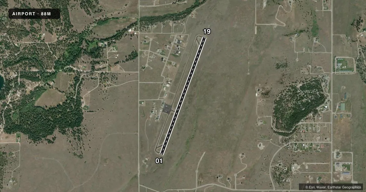
Airport sketch
Runways drawn to scale from FAA survey coordinates, rendered over satellite imagery. Not for navigation.
Approaches & charts
Services on the field
Fuel grades, oxygen, maintenance, ramp storage and lighting — as declared to the FAA by the airport operator.
Fuel & services
- Fuel
- 100LL
Ramp & ground
- Transient storage
- Tie-down
- Lighting schedule
- SEE RMK
- Beacon schedule
- SS-SR
- Beacon
- White / Green (civil land)(WG)
- Wind indicator
- Lighted
- Segmented circle
- Yes
Fuel & FBOs
Cheapest 100LL and Jet A on the field and nearby. Always confirm with the FBO before taxi.
Airport notes
Surface conditions, obstructions, local procedures, lighting outages and other notes published with each FAA cycle.
General notes
- FOR CD CTC SEATTLE ARTCC AT 253-351-3694.
Lighting notes
- ACTVT REIL RWY 01 & 19; PAPI RWY 01 & 19 - CTAF.
- ULTRALIGHT ACT ON & INVOF ARPT.
Fuel notes
- 100LLSELF SVC H24 WITH CREDIT CARD - 406-889-5174.
VFR map & nearby airports
VFR sectional. Tap any ICAO chip to open that airport.
Key facts · 88M
Answer card- ICAO
- 88M
- Name
- EUREKA
- Location
- EUREKA, MONTANA
- Elevation
- 2,671.5 ft MSL
- Traffic pattern altitude
- 3,671.5 ft MSL (1,000 AGL)
- Control tower
- Non-towered (use CTAF)
- Total runways
- 1
- Longest runway
- 01/19 · 4,200 ft
- Published ILS approaches
- 0
- Published frequencies
- 1
- Magnetic variation
- 19°
- Current flight rules
- VFR
- Current wind
- 160° at 4 kt
- Favored runway now
- RWY 19
Eureka Airport sits in Eureka, Montana. Field elevation is 2,671.5 ft MSL. The airport has one runway. Runway 01/19 is 4,200 ft long on asphalt, so plan performance with the field elevation and local conditions in mind. There is no control tower. CTAF is 122.9.
No ILS approaches are published here. Runway end identifier lights are active on 01 and 19. PAPI is available on both ends. The PAPI is activated by the common traffic advisory frequency. Published remarks also note ultralight activity on and near the airport. That means you should keep a sharp lookout in the pattern and on climbout.
The published pattern altitude is not listed. Use the standard 1,000 ft AGL for light piston traffic unless the current Chart Supplement says otherwise. With the field sitting at 2,671.5 ft MSL, that puts the usual pattern near 3,671.5 ft MSL. Wings Unlimited is on the field. It carries AVGAS 100LL and Jet A. Self-serve 100LL is available 24 hours with a credit card. For clearance delivery, contact Seattle ARTCC. If you are new to the area, verify current procedures with the airport operator or the current FAA Chart Supplement before you go.