METAR & TAF 6S4
6S4 does not publish a METAR.
Showing the nearest reporting station: KSLE (MCNARY FLD) · 26.6 NM away. Conditions at 6S4 may differ.
METAR · KSLE
Observed 02:56Z
KSLE 270256Z 30009KT CLR 21/11 A3003 RMK AO2 SLP169 T02110111 53007 $
- Wind
- 300° @ 9 kt
- Visibility
- —
- Temp / Dew
- 21°C / 11°C
- Altimeter
- 30.03 inHg
- Clouds
- CLR
- Density alt
- 1,858 ft
- Ceiling
- Unlimited
- Rules
- VFR
Airport info & contacts
Manager on record, flight service, ARTCC, attendance schedule and pattern altitude — published by the FAA and refreshed every 28 days.
Location
- From city
- 1 NM S
- VFR sectional
- SEATTLE
- ARTCC
- ZSE · SEATTLE
- NOTAM facility
- MMV (NOTAM-D)
Airport manager
- Name
- ANIESE MITCHELL
- Phone
- (503) 602-5520
- Address
- 50287 KINGWOOD AVE., GATES OR 97358
Flight service · Hours
- FSS MMV
- MC MINNVILLE1-800-WX-BRIEF
- Attendance
- Unattended
Frequencies
Tap any row to copy the frequency to your clipboard.
Runways & pattern
Full pagePattern entry · RWY 25
LEFT TRAFFICRunway end performance
| End | TORA | TODA | ASDA | LDA | VGSI | Approach lights | Obstruction |
|---|---|---|---|---|---|---|---|
| 07 | — | — | — | — | — | — | 180', trees, 1800' from thr, 0' R of cntrln, slope 10 |
| 25 | — | — | — | — | — | — | 61', tree, 352' from thr, 114' R of cntrln, slope 5 |
Declared distances in feet. TORA = takeoff run available, TODA = takeoff distance, ASDA = accelerate-stop, LDA = landing distance.
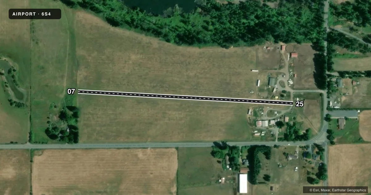
Airport sketch
Runways drawn to scale from FAA survey coordinates, rendered over satellite imagery. Not for navigation.
Approaches & charts
Services on the field
Fuel grades, oxygen, maintenance, ramp storage and lighting — as declared to the FAA by the airport operator.
Fuel & services
- Fuel
- Not available
- Oxygen (bottled)
- Not available
- Oxygen (bulk)
- Not available
Ramp & ground
- Transient storage
- Tie-down
- Landing fee
- No fee published
- Wind indicator
- No
- Segmented circle
- No
Fuel & FBOs
Cheapest 100LL and Jet A on the field and nearby. Always confirm with the FBO before taxi.
Airport notes
Surface conditions, obstructions, local procedures, lighting outages and other notes published with each FAA cycle.
General notes
- MODEL AIRCRAFT FLYING AREA 300 FT SOUTH OF RY.
- FOR CD CTC SEATTLE ARTCC AT 253-351-3694.
Other notes
- EXISTED PRIOR TO 1959.
- 07/25RWY ENDS NOT MKD.
VFR map & nearby airports
VFR sectional. Tap any ICAO chip to open that airport.
Key facts · 6S4
Answer card- ICAO
- 6S4
- Name
- DAVIS
- Location
- GATES, OREGON
- Elevation
- 1,028 ft MSL
- Traffic pattern altitude
- 2,028 ft MSL (1,000 AGL)
- Control tower
- Non-towered (use CTAF)
- Total runways
- 1
- Longest runway
- 07/25 · 1,940 ft
- Published ILS approaches
- 0
- Published frequencies
- 1
- Magnetic variation
- 19°
- Current flight rules
- VFR
- Current wind
- 300° at 9 kt
- Favored runway now
- RWY 25
DAVIS (6S4) sits in Gates, Oregon. The field elevation is 1,028 ft MSL. It has one runway. Runway 07/25 is 1,940 ft of turf, which makes this a short-field stop for light aircraft. The runway ends are not marked, so a careful visual setup matters on arrival and departure.
There is no control tower. CTAF is 122.9. No ILS approaches are published here, so plan with the current chart and your own VFR or non-precision setup as needed. The published pattern altitude is not listed. Use standard 1,000 ft AGL unless the current Chart Supplement says otherwise. That puts the pattern at about 2,028 ft MSL based on the field elevation.
No on-field FBOs are listed. Check with the airport operator or the FBO directly by phone before you go if you need fuel or services. One published remark to keep in mind is the model aircraft flying area about 300 feet south of the runway. Another is that clearance delivery is handled through Seattle ARTCC at 253-351-3694. This field also existed before 1959, which tells you it has a long local history. The operational details that matter are the turf surface, short length and the unmarked runway ends.