METAR & TAF KCVO
Current METAR
Observed 10:56Z
KCVO 271056Z 21003KT 10SM CLR 09/09 A3011 RMK AO2 SLP197 T00940089
- Wind
- 210° @ 3 kt
- Visibility
- 10 SM
- Temp / Dew
- 9°C / 9°C
- Altimeter
- 30.11 inHg
- Clouds
- CLR
- Density alt
- -646 ft
- Ceiling
- Unlimited
- Rules
- VFR
Airport info & contacts
Manager on record, flight service, ARTCC, attendance schedule and pattern altitude — published by the FAA and refreshed every 28 days.
Location
- From city
- 4 NM SW
- VFR sectional
- KLAMATH FALLS
- Pattern altitude
- 800 ft AGL · 1,050 ft MSL
- ARTCC
- ZSE · SEATTLE
- NOTAM facility
- CVO (NOTAM-D)
Airport manager
- Name
- CITY OF CORVALLIS
- Phone
- 541-228-5523
- Address
- PO BOX 1083, CORVALLIS OR 97339-1083
Flight service · Hours
- FSS MMV
- MC MINNVILLE1-800-WX-BRIEF
- Attendance
- 0800-DUSK
Frequencies
Tap any row to copy the frequency to your clipboard.
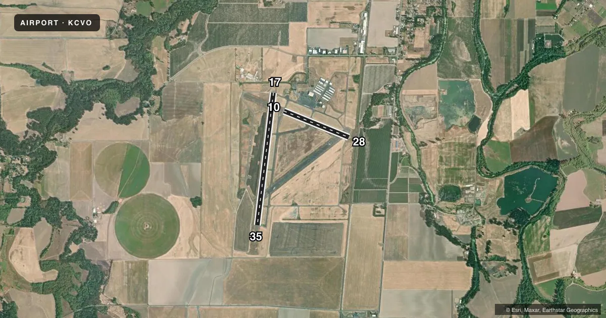
Runways & pattern
Full pagePattern entry · RWY 17
LEFT TRAFFIC| Runway | Heading (°M) | Length | Surface | Traffic |
|---|---|---|---|---|
| 17/35Favored | 172° / 352° | 5,900 ft | ASPH | Standard L |
| 10/28 | 97° / 277° | 3,100 ft | ASPH | Standard L |
Runway end performance
| End | TORA | TODA | ASDA | LDA | VGSI | Approach lights | Obstruction |
|---|---|---|---|---|---|---|---|
| 17 | 5,900' | 5,900' | 5,900' | 5,900' | VASI 4-box left(3°) | MALSR | — |
| 35 | 5,900' | 5,900' | 5,900' | 5,900' | VASI 4-box left(3°) | — | — |
| 10 | 3,100' | 3,100' | 3,100' | 3,100' | — | — | — |
| 28 | 3,100' | 3,100' | 3,100' | 2,872' | PAPI 4-box left(3°) | — | 21', rr, 380' from thr, 0' R of cntrln, slope 8 |
Declared distances in feet. TORA = takeoff run available, TODA = takeoff distance, ASDA = accelerate-stop, LDA = landing distance.
Airport sketch
Runways drawn to scale from FAA survey coordinates, rendered over satellite imagery. Not for navigation.
Approaches & charts
ILS · 1
Services on the field
Fuel grades, oxygen, maintenance, ramp storage and lighting — as declared to the FAA by the airport operator.
Fuel & services
- Fuel
- 100LLA
- Oxygen (bottled)
- High pressure
- Oxygen (bulk)
- HIGH/LOW
- Airframe repair
- Major
- Power plant repair
- Major
- Other services
- AFRT,AMB,CHTR,INSTR,RNTL,SALES,SURV
Ramp & ground
- Transient storage
- Tie-down
- Hangar
- Landing fee
- No fee published
- Customs
- Not available
- Lighting schedule
- SEE RMK
- Beacon schedule
- SS-SR
- Beacon
- White / Green (civil land)(WG)
- Wind indicator
- Lighted
- Segmented circle
- Yes
Fuel & FBOs
Cheapest 100LL and Jet A on the field and nearby. Always confirm with the FBO before taxi.
Airport notes
Surface conditions, obstructions, local procedures, lighting outages and other notes published with each FAA cycle.
General notes
- MIGRATORY WATERFOWL & OTR BIRDS ON & INVOF ARPT.
- SURF COND NOT RPRT DLY 1700-0800 AND ALL TIMES SATURDAYS AND SUNDAYS.
- FOR CD CTC CASCADE APCH AT 541-607-4674/4675, WHEN APCH CLSD CTC SEATTLE ARTCC AT 253-351-3694.
Lighting notes
- ACTVT MALSR RWY 17, REIL RWY 35; VASI RWY 17 & 35; PAPI RWY 28; CTAF. ACTVT HIRL 17/35 AND MIRL 10/28 SS-SR CTAF.
Approach & departure obstructions
- 10RWY 10/28 HAS WHITE SIDE STRIPES.
- 28APCH RATIO 29:1 FM DSPLCD THR.
Other notes
- ESTABD PRIOR TO 1959.
VFR map & nearby airports
VFR sectional. Tap any ICAO chip to open that airport.
Key facts · KCVO
Answer card- ICAO
- KCVO
- Name
- CORVALLIS MUNI
- Location
- CORVALLIS, OREGON
- Elevation
- 249.9 ft MSL
- Traffic pattern altitude
- 1,049.9 ft MSL (800 AGL)
- Control tower
- Non-towered (use CTAF)
- Total runways
- 2
- Longest runway
- 17/35 · 5,900 ft
- Published ILS approaches
- 1
- Published frequencies
- 4
- Magnetic variation
- 15°
- Current flight rules
- VFR
- Current wind
- 210° at 3 kt
- Favored runway now
- RWY 17
Corvallis Muni is in Corvallis, Oregon. The field elevation is 249.9 ft MSL. It has two asphalt runways. The longest is 5,900 ft on runway 17/35. There is no control tower. CTAF and UNICOM are both 123.075. Approach and departure service is on 127.5 or 348.7 with Cascade. The airport has one ILS approach. It serves runway 17.
Pattern altitude is 800 ft AGL. That is 1,049.9 ft MSL. Corvallis Aero Service is on the field. It carries 100LL, Jet A and Jet A Prist. If you need clearance delivery, contact Cascade Approach before departure. If approach is closed, Seattle ARTCC is the backup contact listed in the Chart Supplement.
A few operational points matter here. Birds are reported on and near the airport. Keep a sharp scan on climbout and on final. Runway 17 has MALSR lighting. Runway 35 has REIL. VASI is available for runways 17 and 35. PAPI is available for runway 28. Runway 10/28 has white side stripes. The published remarks also note an obstruction-related approach issue on runway 28 from the displaced threshold. Surface condition is not reported daily overnight or on weekends, so check the current Chart Supplement and call ahead if runway condition matters for your arrival.