METAR & TAF KONP
Current METAR
Observed 04:15Z
KONP 270415Z AUTO 00000KT 10SM CLR 15/12 A3012 RMK AO2
- Wind
- 000° @ 0 kt
- Visibility
- 10 SM
- Temp / Dew
- 15°C / 12°C
- Altimeter
- 30.12 inHg
- Clouds
- CLR
- Density alt
- -49 ft
- Ceiling
- Unlimited
- Rules
- VFR
Airport info & contacts
Manager on record, flight service, ARTCC, attendance schedule and pattern altitude — published by the FAA and refreshed every 28 days.
Location
- From city
- 3 NM S
- VFR sectional
- SEATTLE
- ARTCC
- ZSE · SEATTLE
- NOTAM facility
- ONP (NOTAM-D)
Airport manager
- Name
- LANCE VANDERBECK
- Phone
- (541) 867-7422
- Address
- 135 SE 84TH, NEWPORT OR 97365
Flight service · Hours
- FSS MMV
- MC MINNVILLE1-800-WX-BRIEF
- Attendance
- 0800-1700
Frequencies
Tap any row to copy the frequency to your clipboard.
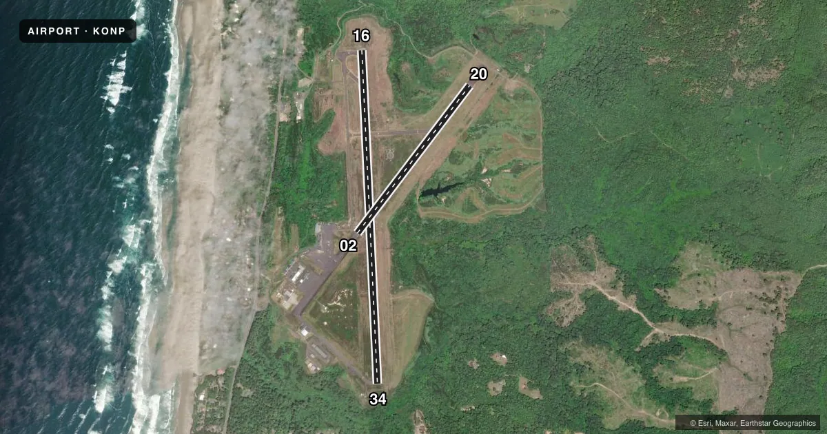
Runways & pattern
Full pagePattern entry · RWY 16
RIGHT TRAFFIC| Runway | Heading (°M) | Length | Surface | Traffic |
|---|---|---|---|---|
| 16/34 | 162° / 342° | 5,398 ft | ASPH | 16 R |
| 02/20 | 22° / 202° | 3,001 ft | ASPH | 20 R |
Runway end performance
| End | TORA | TODA | ASDA | LDA | VGSI | Approach lights | Obstruction |
|---|---|---|---|---|---|---|---|
| 16 | 5,398' | 5,398' | 5,398' | 5,398' | PAPI 4-box left(3°) | MALSR | 24', trees, 356' from thr, 450' R of cntrln, slope 6 |
| 34 | 5,398' | 5,398' | 5,398' | 5,098' | PAPI 4-box left(3°) | — | 25', trees, 467' from thr, 0' R of cntrln, slope 10 |
| 02 | 3,001' | 3,001' | 3,001' | 3,001' | — | — | 17', gnd, 875' from thr, 300' R of cntrln, slope 39 |
| 20 | 3,001' | 3,001' | 3,001' | 3,001' | — | — | 67', tree, 1085' from thr, 100' R of cntrln, slope 13 |
Declared distances in feet. TORA = takeoff run available, TODA = takeoff distance, ASDA = accelerate-stop, LDA = landing distance.
Airport sketch
Runways drawn to scale from FAA survey coordinates, rendered over satellite imagery. Not for navigation.
Approaches & charts
ILS · 1
Services on the field
Fuel grades, oxygen, maintenance, ramp storage and lighting — as declared to the FAA by the airport operator.
Fuel & services
- Fuel
- 100LLA
- Oxygen (bottled)
- Not available
- Oxygen (bulk)
- Not available
- Other services
- AFRT
Ramp & ground
- Transient storage
- Tie-down
- Hangar
- Landing fee
- No fee published
- Customs
- Not available
- Lighting schedule
- SEE RMK
- Beacon
- White / Green (civil land)(WG)
- Wind indicator
- Lighted
- Segmented circle
- Yes
Fuel & FBOs
Cheapest 100LL and Jet A on the field and nearby. Always confirm with the FBO before taxi.
Airport notes
Surface conditions, obstructions, local procedures, lighting outages and other notes published with each FAA cycle.
General notes
- BIRDS, DEER & COYOTES ON AND INVOF ARPT.
- FOR CD IF UNA TO CTC ON FSS FREQ, CTC SEATTLE ARTCC AT 253-351-3694.
- PILOTS CONDUCTING EFVS OPS; BE AWARE LED ALS IN USE RWY 16.
Lighting notes
- ACTVT MALSR RWY 16; MIRL RYS 02/20 & HIRL 16/34 AND PAPIS RWY 16 & RWY 34 AND REIL RY 34 - CTAF.
Fuel notes
- 100LLFOR FUEL AFT HRS CALL 541-867-7422 OR 541-530-1364.
Approach & departure obstructions
- 34RWY 34 PAPI BEYOND 3DEG LEFT AND 5DEG RIGHT OF RCL UNUSABLE
Other notes
- ESTABD PRIOR TO 1959.
- PPR FOR ACR OPNS WITH MORE THAN 30 PSGR SEATS CALL AMGR 541-867-7422.
VFR map & nearby airports
VFR sectional. Tap any ICAO chip to open that airport.
Key facts · KONP
Answer card- ICAO
- KONP
- Name
- NEWPORT MUNI
- Location
- NEWPORT, OREGON
- Elevation
- 160.1 ft MSL
- Traffic pattern altitude
- 1,160.1 ft MSL (1,000 AGL)
- Control tower
- Non-towered (use CTAF)
- Total runways
- 2
- Longest runway
- 16/34 · 5,398 ft
- Published ILS approaches
- 1
- Published frequencies
- 2
- Magnetic variation
- 15°
- Current flight rules
- VFR
- Current wind
- 000° at 0 kt
- Favored runway now
- –
Newport Muni sits in Newport, Oregon on the central coast. Field elevation is 160.1 ft MSL. The airport has two asphalt runways. Runway 16/34 is the longest at 5,398 ft. Runway 02/20 is 3,001 ft. There is no control tower. CTAF and UNICOM are both 122.8.
An ILS is available for runway 16. The published remarks also note LED approach lighting on runway 16. High intensity runway lights are on 16/34. Medium intensity runway lights are on 02/20. PAPI is published for runways 16 and 34. REIL is on runway 34. The Chart Supplement also notes a lighting issue on the approach lighting system for runway 16. If you are planning an arrival here, check the current Chart Supplement before departure.
Pattern altitude is not published. Use the standard 1,000 ft AGL for light piston operations unless current local guidance says otherwise. The field is on the coast. Expect marine weather to matter. The published remarks also call out birds, deer and coyotes on and near the airport. That is worth keeping in mind on taxi, takeoff and landing. Newport Municipal Airport is the on-field FBO. It carries 100LL, Jet A and Jet A Prist. Call ahead if you need after-hours fuel.