METAR & TAF S45
S45 does not publish a METAR.
Showing the nearest reporting station: KONP (NEWPORT MUNI) · 17.8 NM away. Conditions at S45 may differ.
METAR · KONP
Observed 11:15Z
KONP 271115Z AUTO 10003KT 10SM OVC009 11/11 A3012 RMK AO2
- Wind
- 100° @ 3 kt
- Visibility
- 10 SM
- Temp / Dew
- 11°C / 11°C
- Altimeter
- 30.12 inHg
- Clouds
- OVC
- Density alt
- -642 ft
- Ceiling
- 900 ft AGL
- Rules
- IFR
Airport info & contacts
Manager on record, flight service, ARTCC, attendance schedule and pattern altitude — published by the FAA and refreshed every 28 days.
Location
- From city
- 1 NM SE
- VFR sectional
- SEATTLE
- ARTCC
- ZSE · SEATTLE
- NOTAM facility
- MMV (NOTAM-D)
Airport manager
- Name
- STATE AIRPORTS MANAGER
- Phone
- 503-378-4880
- Address
- 3040 25TH ST SE, SALEM OR 97302-1125
Flight service · Hours
- FSS MMV
- MC MINNVILLE1-800-WX-BRIEF
- Attendance
- Unattended
Frequencies
Tap any row to copy the frequency to your clipboard.
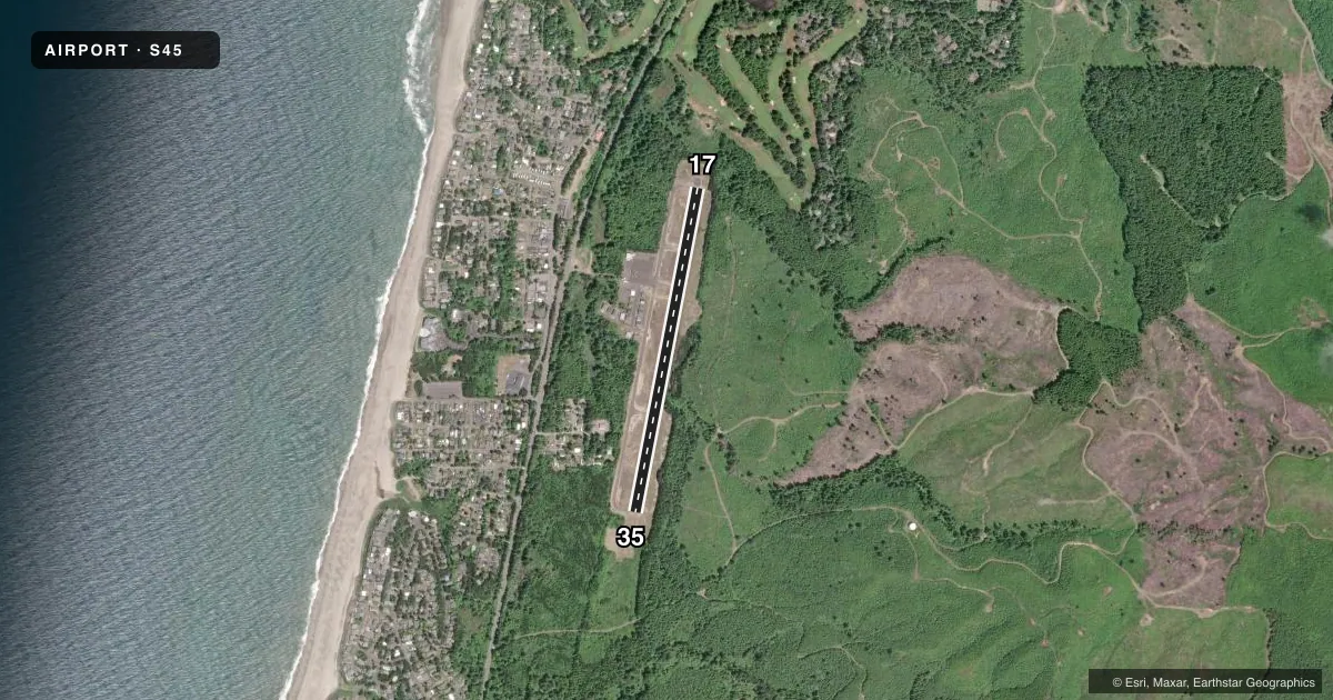
Runways & pattern
Full pagePattern entry · RWY 35
LEFT TRAFFICRunway end performance
| End | TORA | TODA | ASDA | LDA | VGSI | Approach lights | Obstruction |
|---|---|---|---|---|---|---|---|
| 17 | — | — | — | — | — | — | 88', trees, 960' from thr, 125' R of cntrln, slope 8 |
| 35 | — | — | — | — | — | — | 23', trees, 323' from thr, 69' R of cntrln, slope 5 |
Declared distances in feet. TORA = takeoff run available, TODA = takeoff distance, ASDA = accelerate-stop, LDA = landing distance.
Airport sketch
Runways drawn to scale from FAA survey coordinates, rendered over satellite imagery. Not for navigation.
Approaches & charts
Services on the field
Fuel grades, oxygen, maintenance, ramp storage and lighting — as declared to the FAA by the airport operator.
Fuel & services
- Fuel
- Not available
- Oxygen (bottled)
- Not available
- Oxygen (bulk)
- Not available
- Airframe repair
- Not available
- Power plant repair
- Not available
Ramp & ground
- Transient storage
- Tie-down
- Landing fee
- No fee published
- Customs
- Not available
- Lighting schedule
- SEE RMK
- Beacon schedule
- SS-SR
- Beacon
- White / Green (civil land)(WG)
- Wind indicator
- Lighted
- Segmented circle
- Yes
Fuel & FBOs
Cheapest 100LL and Jet A on the field and nearby. Always confirm with the FBO before taxi.
Airport notes
Surface conditions, obstructions, local procedures, lighting outages and other notes published with each FAA cycle.
General notes
- WILDLIFE ON AND INVOF OF AIRPORT.
- FOR CD CTC SEATTLE ARTCC AT 253-351-3694.
- SFC CONDS NOT RPRTD.
Lighting notes
- MIRL RY 17/35 PRESET LOW INTST; ACTVT HIGHER INTST - CTAF.
Approach & departure obstructions
- 1735' TREES 0-200' FM RY END 105-120' L OF CNTRLN.
- 35RWY 35 10 FT BRUSH AT 75-200 FT FM RWY END & 90-125 FT L OF CNTRLN.
Other notes
- UNICOM ATTENDED IRREGULARLY.
VFR map & nearby airports
VFR sectional. Tap any ICAO chip to open that airport.
Key facts · S45
Answer card- ICAO
- S45
- Name
- SILETZ BAY STATE
- Location
- GLENEDEN BEACH, OREGON
- Elevation
- 69.2 ft MSL
- Traffic pattern altitude
- 1,069.2 ft MSL (1,000 AGL)
- Control tower
- Non-towered (use CTAF)
- Total runways
- 1
- Longest runway
- 17/35 · 3,297 ft
- Published ILS approaches
- 0
- Published frequencies
- 2
- Magnetic variation
- 19°
- Current flight rules
- IFR
- Current wind
- 100° at 3 kt
- Favored runway now
- RWY 35
Siletz Bay State Airport sits in Gleneden Beach, Oregon. Field elevation is 69.2 ft MSL. The airport has one runway, 17/35, at 3,297 ft. There is no control tower. CTAF and UNICOM are both 122.7, though UNICOM is attended irregularly. No ILS approaches are published here.
Pattern altitude is not published. Use 1,000 ft AGL for light piston operations unless current local guidance says otherwise. The runway lighting on 17/35 is preset to low intensity. Higher intensity is activated on the CTAF. That matters if you arrive after dark.
The published remarks also call out brush near the departure end of runway 35 and trees near the departure end of runway 17. Wildlife is on and in the vicinity of the airport. Surface conditions are not reported, so plan your landing with current field conditions in mind. There are no on-field FBOs listed, so confirm services before you go. For clearance delivery, contact Seattle ARTCC at 253-351-3694. With a single asphalt runway and coastal conditions near the field, give yourself extra time to brief the departure and arrival, especially if you are planning a night arrival or operating a larger aircraft.