METAR & TAF 5S4
5S4 does not publish a METAR.
Showing the nearest reporting station: KONP (NEWPORT MUNI) · 5.2 NM away. Conditions at 5S4 may differ.
METAR · KONP
Observed 05:55Z
KONP 270555Z AUTO 15003KT 10SM CLR 13/12 A3013 RMK AO2
- Wind
- 150° @ 3 kt
- Visibility
- 10 SM
- Temp / Dew
- 13°C / 12°C
- Altimeter
- 30.13 inHg
- Clouds
- CLR
- Density alt
- -486 ft
- Ceiling
- Unlimited
- Rules
- VFR
Airport info & contacts
Manager on record, flight service, ARTCC, attendance schedule and pattern altitude — published by the FAA and refreshed every 28 days.
Location
- From city
- 1 NM SW
- VFR sectional
- SEATTLE
- ARTCC
- ZSE · SEATTLE
- NOTAM facility
- MMV (NOTAM-D)
Airport manager
- Name
- ANTHONY BEACH
- Phone
- 503-378-4880
- Address
- 3040 25TH ST SE, SALEM OR 97302
Flight service · Hours
- FSS MMV
- MC MINNVILLE1-800-WX-BRIEF
- Attendance
- Unattended
Frequencies
Tap any row to copy the frequency to your clipboard.
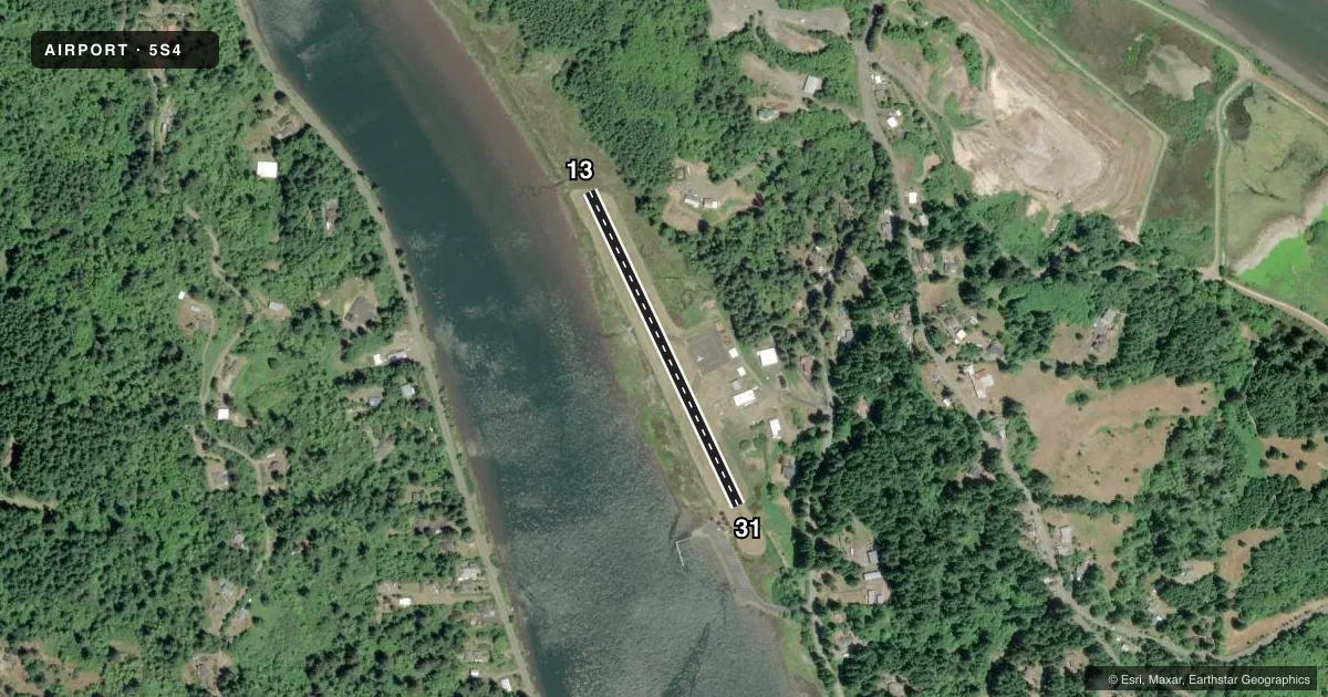
Runways & pattern
Full pagePattern entry · RWY 13
LEFT TRAFFICRunway end performance
| End | TORA | TODA | ASDA | LDA | VGSI | Approach lights | Obstruction |
|---|---|---|---|---|---|---|---|
| 13 | — | — | — | — | — | — | 110', trees, 1567' from thr, 206' R of cntrln, slope 12 |
| 31 | — | — | — | — | — | — | 79', trees, 444' from thr, 69' R of cntrln, slope 3 |
Declared distances in feet. TORA = takeoff run available, TODA = takeoff distance, ASDA = accelerate-stop, LDA = landing distance.
Airport sketch
Runways drawn to scale from FAA survey coordinates, rendered over satellite imagery. Not for navigation.
Approaches & charts
Services on the field
Fuel grades, oxygen, maintenance, ramp storage and lighting — as declared to the FAA by the airport operator.
Fuel & services
- Fuel
- Not available
Ramp & ground
- Transient storage
- Tie-down
- Landing fee
- No fee published
- Wind indicator
- Yes
- Segmented circle
- No
Fuel & FBOs
Cheapest 100LL and Jet A on the field and nearby. Always confirm with the FBO before taxi.
Airport notes
Surface conditions, obstructions, local procedures, lighting outages and other notes published with each FAA cycle.
General notes
- PPR FOR USE - AMGR.
- DEER & WATERFOWL INVOF OF ARPT.
- FOR CD CTC SEATTLE ARTCC AT 253-351-3694.
- SFC COND NOT RPRTD.
Runway surface & condition
- 13/31CTN: TREES IN TRSN AREA; CURVE APCH FM OVR WATER DUE TO OBSTNS. +20 FT TREES IN TRSN SFC 50-75 FT FM RWY EDGE. MAY BE FLOODED DURG HIGH TIDE; DRIFTWOOD ON SFC PSBL.
Approach & departure obstructions
- 1310 FT TREES & BRUSH 0-20 FT FM RWY END 50 FT R OF CNTRLN.
- 3130 FT TREES 80 FT FM RWY END 85 FT L.
- 134 FT DITCH 10 FT OFF PAVEMENT.
- 13SMLR THAN STD.
- 31SMLR THAN STD.
- 13100 TREES 125 FT L OF CNTRLN.
- 13120 FT TREES NEAR CNTRLN.
- 31HIGHER TRRN & TREES ALG R SIDE OF CNTRLN.
Other notes
- ESTABD PRIOR TO 1959.
- OVR GROWN GRASS.
VFR map & nearby airports
VFR sectional. Tap any ICAO chip to open that airport.
Key facts · 5S4
Answer card- ICAO
- 5S4
- Name
- TOLEDO STATE
- Location
- TOLEDO, OREGON
- Elevation
- 12 ft MSL
- Traffic pattern altitude
- 1,012 ft MSL (1,000 AGL)
- Control tower
- Non-towered (use CTAF)
- Total runways
- 1
- Longest runway
- 13/31 · 1,750 ft
- Published ILS approaches
- 0
- Published frequencies
- 1
- Magnetic variation
- 19°
- Current flight rules
- VFR
- Current wind
- 150° at 3 kt
- Favored runway now
- RWY 13
Toledo State is in Toledo, Oregon. The field elevation is 12 ft MSL. It has one runway, 13/31, which is 1,750 ft long and asphalt. There is no control tower. CTAF is 122.9. No ILS approaches are published.
Pattern altitude is not published. Use the standard 1,000 ft AGL pattern unless the current Chart Supplement says otherwise. That puts the light aircraft pattern at 1,012 ft MSL based on the field elevation in the facts here.
This is a low-elevation coastal field with several operational cautions. The published remarks call out trees in the transition area. They also note a curved approach from over water due to obstructions. Possible flooding on runway 13/31 during high tide is another factor. Driftwood may also be on the surface. Deer and waterfowl are in the area. Runway 13 has trees and brush near the end plus tall trees near the centerline. Runway 31 has higher terrain and trees along the right side of centerline. Runway 31 markings are smaller than standard.
No on-field FBOs are listed. Check the airport operator or call the field directly before arrival if you need fuel or local handling details. For clearance delivery, the published remark says to contact Seattle ARTCC at 253-351-3694.