METAR & TAF KPFC
KPFC does not publish a METAR.
Showing the nearest reporting station: KTMK (TILLAMOOK) · 14.5 NM away. Conditions at KPFC may differ.
METAR · KTMK
Observed 06:15Z
KTMK 270615Z AUTO 13004KT 10SM SCT120 15/15 A3011 RMK AO2
- Wind
- 130° @ 4 kt
- Visibility
- 10 SM
- Temp / Dew
- 15°C / 15°C
- Altimeter
- 30.11 inHg
- Clouds
- SCT
- Density alt
- -223 ft
- Ceiling
- Unlimited
- Rules
- VFR
Airport info & contacts
Manager on record, flight service, ARTCC, attendance schedule and pattern altitude — published by the FAA and refreshed every 28 days.
Location
- From city
- 1 NM S
- VFR sectional
- SEATTLE
- ARTCC
- ZSE · SEATTLE
- NOTAM facility
- MMV (NOTAM-D)
Airport manager
- Name
- STATE AIRPORT MANAGER
- Phone
- 503-378-4880
- Address
- 3040 25TH ST SE, SALEM OR 97302-1125
Flight service · Hours
- FSS MMV
- MC MINNVILLE1-800-WX-BRIEF
- Attendance
- Unattended
Frequencies
Tap any row to copy the frequency to your clipboard.
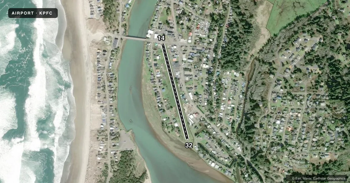
Runways & pattern
Full pagePattern entry · RWY 14
LEFT TRAFFICRunway end performance
| End | TORA | TODA | ASDA | LDA | VGSI | Approach lights | Obstruction |
|---|---|---|---|---|---|---|---|
| 14 | — | — | — | — | — | — | 40', tree, 206' from thr, 0' R of cntrln, slope 0 |
Declared distances in feet. TORA = takeoff run available, TODA = takeoff distance, ASDA = accelerate-stop, LDA = landing distance.
Airport sketch
Runways drawn to scale from FAA survey coordinates, rendered over satellite imagery. Not for navigation.
Approaches & charts
Services on the field
Fuel grades, oxygen, maintenance, ramp storage and lighting — as declared to the FAA by the airport operator.
Fuel & services
- Fuel
- Not available
- Oxygen (bottled)
- Not available
- Oxygen (bulk)
- Not available
Ramp & ground
- Transient storage
- Tie-down
- Landing fee
- No fee published
- Customs
- Not available
- Wind indicator
- Yes
- Segmented circle
- No
Fuel & FBOs
Cheapest 100LL and Jet A on the field and nearby. Always confirm with the FBO before taxi.
Airport notes
Surface conditions, obstructions, local procedures, lighting outages and other notes published with each FAA cycle.
General notes
- RY MAY BE UNDER WATER DURING WINTER HIGH TIDES.
- OWNER ADZS CTC WITH DEPT OF AVIATION 503-378-4880 PRIOR TO USE.
- SOFT & MARSHY OFF PAVED AREAS.
- OCCASIONAL DRIFTWOOD ON RWY DUE TO FLOODING
- DOWNWIND LNDGS NOT RCMDD AND MAY NOT BE PSBL.
- MANY CLOSE IN OBSTNS ON BOTH SIDES OF RY. EXPECT LOW LEVEL TURBULENCE DURG CROSSWIND CONDS.
- ASSORTED TREES AND 40 FT POWERLINE AT 500 FT NORTH OF RY.
- PRE-TKOF ENG RUN-UPS TO BE CONDUCTED AT THE PRKG RAMP ONLY.
- FOR CD CTC SEATTLE ARTCC AT 253-351-3694.
- SFC CONDS NOT RPRTD.
Approach & departure obstructions
- 14MANY OBJECTS WI 30 FT OF CNTRLN AND FM 0-200 FT FM RWY END: +8 FT FENCE & BLDG MARKED AND LGTD 30 FT R OF CNTRLN AT THR; 3 FT CABLE FENCE & 15 FT PUB ROAD 2 FT FM RWY END; BLDGS, ANT, LUMBER PILES, POLES & MISC EQPT TO +30 FT FM 50 FT TO +200 FT FM RWY END.
- 3225 FT TREES AT 1 FT FROM RWY END AND 50 FT LEFT OF CNTRLN; 20 FT HOUSE AT 145 - 200 FT FROM RWY END AND 100 - 125 FT RIGHT OF CNTRLN.
- 1411:1 BASED ON DISPLACED THRESHOLD.
- 14COML VEHICLES TO 15 FT IN HGT XNG WI 20 FT OF RWY END
Other notes
- ESTABD PRIOR TO 1959.
VFR map & nearby airports
VFR sectional. Tap any ICAO chip to open that airport.
Key facts · KPFC
Answer card- ICAO
- KPFC
- Name
- PACIFIC CITY STATE
- Location
- PACIFIC CITY, OREGON
- Elevation
- 10 ft MSL
- Traffic pattern altitude
- 1,010 ft MSL (1,000 AGL)
- Control tower
- Non-towered (use CTAF)
- Total runways
- 1
- Longest runway
- 14/32 · 1,860 ft
- Published ILS approaches
- 0
- Published frequencies
- 1
- Magnetic variation
- 19°
- Current flight rules
- VFR
- Current wind
- 130° at 4 kt
- Favored runway now
- RWY 14
Pacific City State Airport (KPFC) sits in Pacific City, Oregon at 10 ft MSL. It has one runway, 14/32, which is 1,860 ft long on asphalt. There is no control tower. CTAF is 122.9. No ILS approaches are published. The field is low and coastal, so winter tides and flooding can matter here. The runway may be under water during winter high tides. Surface conditions are not reported.
The published pattern altitude is not listed, so use the standard 1,000 ft AGL for light piston operations unless the current FAA Chart Supplement says otherwise. With a field elevation of 10 ft MSL, that puts the usual pattern reference at 1,010 ft MSL. The airport has no on-field FBOs listed. Pre-takeoff engine run-ups must be done at the parking ramp only. Expect close-in obstructions on both sides of the runway. Downwind landings are not recommended and may not be possible. The runway also has reported driftwood after flooding, plus soft and marshy areas off the pavement. Runway 14 has a displaced-threshold obstacle clearance slope and several close obstacles near the threshold. Runway 32 has trees near the end and a house off the right side. This is a short coastal strip, so plan conservatively and verify current conditions before you go.