METAR & TAF 3S7
3S7 does not publish a METAR.
Showing the nearest reporting station: KTMK (TILLAMOOK) · 17.5 NM away. Conditions at 3S7 may differ.
METAR · KTMK
Observed 05:35Z
KTMK 270535Z AUTO 00000KT 10SM CLR 15/15 A3011 RMK AO2
- Wind
- 000° @ 0 kt
- Visibility
- 10 SM
- Temp / Dew
- 15°C / 15°C
- Altimeter
- 30.11 inHg
- Clouds
- CLR
- Density alt
- -198 ft
- Ceiling
- Unlimited
- Rules
- VFR
Airport info & contacts
Manager on record, flight service, ARTCC, attendance schedule and pattern altitude — published by the FAA and refreshed every 28 days.
Location
- From city
- 2 NM S
- VFR sectional
- SEATTLE
- ARTCC
- ZSE · SEATTLE
- NOTAM facility
- MMV (NOTAM-D)
Airport manager
- Name
- STATE AIRPORT MANAGER
- Phone
- 503-378-4880
- Address
- 3040 25TH ST SE, SALEM OR 97302-1125
Flight service · Hours
- FSS MMV
- MC MINNVILLE1-800-WX-BRIEF
- Attendance
- Unattended
Frequencies
Tap any row to copy the frequency to your clipboard.
Runways & pattern
Full pagePattern entry · RWY 15
LEFT TRAFFICRunway end performance
| End | TORA | TODA | ASDA | LDA | VGSI | Approach lights | Obstruction |
|---|---|---|---|---|---|---|---|
| 15 | — | — | — | — | — | — | 5', hill, 240' from thr, 0' R of cntrln, slope 8 |
Declared distances in feet. TORA = takeoff run available, TODA = takeoff distance, ASDA = accelerate-stop, LDA = landing distance.
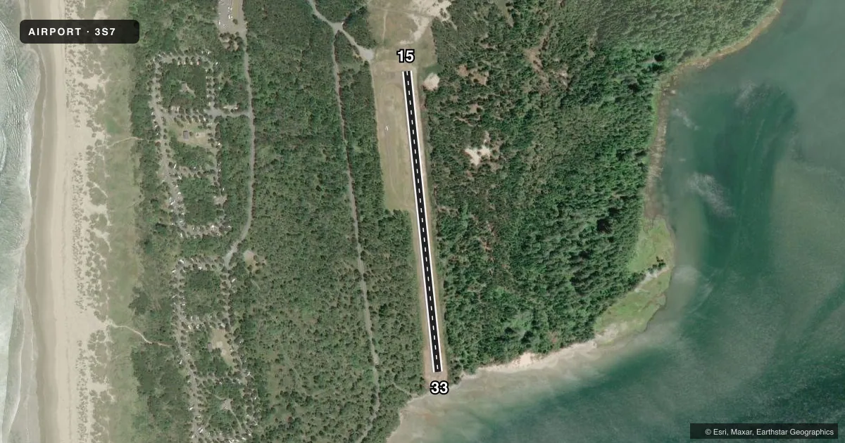
Airport sketch
Runways drawn to scale from FAA survey coordinates, rendered over satellite imagery. Not for navigation.
Approaches & charts
Services on the field
Fuel grades, oxygen, maintenance, ramp storage and lighting — as declared to the FAA by the airport operator.
Fuel & services
- Fuel
- Not available
- Airframe repair
- Not available
- Power plant repair
- Not available
Ramp & ground
- Transient storage
- Tie-down
- Landing fee
- No fee published
- Wind indicator
- Yes
- Segmented circle
- Yes
Fuel & FBOs
Cheapest 100LL and Jet A on the field and nearby. Always confirm with the FBO before taxi.
Airport notes
Surface conditions, obstructions, local procedures, lighting outages and other notes published with each FAA cycle.
General notes
- 20' GRVL TWY TO TIEDOWN AREA.
- -2' DITCH 90' FM CNTRLN WEST OF RWY MRKED W/SIGNS.
- WILDLIFE INVOF RY.
- UN-PAVED TAXIWAY AND RAMP
- FOR CD CTC SEATTLE ARTCC AT 253-351-3694.
- SFC CONDS NOT RPRTD.
Approach & departure obstructions
- 154 FT HILL FM 40-200 FT FM RWY END AND 60 FT LEFT AND RIGHT OF CNTRLN, ALSO 10 FT HILL AT 180 FT FM RWY END AND 120 FT RIGHT OF CNTRLN.
- 33RWY 33 +3 FT CABLE FENCE AT 140 FT ON CNTRLN. ALSO 6' BRUSH AT 120' FROM RWY END BOTH SIDES OF CNTRLN.
Other notes
- ESTABD PRIOR TO 1959.
- NON-STD SEGMENTED CIRCLE; LAID OUT WITH TIRES.
VFR map & nearby airports
VFR sectional. Tap any ICAO chip to open that airport.
Key facts · 3S7
Answer card- ICAO
- 3S7
- Name
- NEHALEM BAY STATE
- Location
- MANZANITA, OREGON
- Elevation
- 30 ft MSL
- Traffic pattern altitude
- 1,030 ft MSL (1,000 AGL)
- Control tower
- Non-towered (use CTAF)
- Total runways
- 1
- Longest runway
- 15/33 · 2,350 ft
- Published ILS approaches
- 0
- Published frequencies
- 1
- Magnetic variation
- 20°
- Current flight rules
- VFR
- Current wind
- 000° at 0 kt
- Favored runway now
- –
Nehalem Bay State Airport sits in Manzanita, Oregon at 30 ft MSL on the north Oregon coast. It has one runway, 15/33, which is 2,350 ft long with an asphalt surface. The field is non-towered. CTAF is 122.9. No ILS approaches are published here.
Pattern altitude is not published. Use the standard 1,000 ft AGL unless the current FAA Chart Supplement says otherwise. That puts the light-aircraft pattern at 1,030 ft MSL based on the listed field elevation. The runway headings are magnetic. Runway 15 is 174°. Runway 33 is 354°.
There are no on-field FBOs listed. The published remarks show a few things a first-time pilot should plan for. Runway 33 has cable fence and brush close to the departure end. Runway 15 has hill terrain near the end of the runway. Wildlife is also noted in the runway area. The taxiway to the tiedown area is 20 ft gravel. The taxiway and ramp are unpaved. Surface conditions are not reported. Clearance delivery is handled through Seattle ARTCC at 253-351-3694. Expect to verify current field condition and use the current FAA Chart Supplement before you go.