METAR & TAF 56S
56S does not publish a METAR.
Showing the nearest reporting station: KAST (ASTORIA RGNL) · 8.7 NM away. Conditions at 56S may differ.
METAR · KAST
Observed 16:55Z
KAST 261655Z AUTO 20008KT 4SM BR FEW007 SCT011 OVC028 16/14 A3006 RMK AO2 RAE1558B46E55 SLP179 P0000 T01560144 $
- Wind
- 200° @ 8 kt
- Visibility
- 4 SM
- Temp / Dew
- 16°C / 14°C
- Altimeter
- 30.06 inHg
- Clouds
- OVC
- Density alt
- -39 ft
- Ceiling
- 2,800 ft AGL
- Rules
- MVFR
Airport info & contacts
Manager on record, flight service, ARTCC, attendance schedule and pattern altitude — published by the FAA and refreshed every 28 days.
Location
- From city
- 1 NM NE
- VFR sectional
- SEATTLE
- ARTCC
- ZSE · SEATTLE
- NOTAM facility
- MMV (NOTAM-D)
Airport manager
- Name
- PAUL STULL
- Phone
- 503-738-5112
- Address
- 989 BROADWAY, SEASIDE OR 97138
Flight service · Hours
- FSS MMV
- MC MINNVILLE1-800-WX-BRIEF
- Attendance
- Unattended
Frequencies
Tap any row to copy the frequency to your clipboard.
Runways & pattern
Full pagePattern entry · RWY 16
LEFT TRAFFICRunway end performance
| End | TORA | TODA | ASDA | LDA | VGSI | Approach lights | Obstruction |
|---|---|---|---|---|---|---|---|
| 16 | — | — | — | — | — | — | 13', brush, 296' from thr, 0' R of cntrln, slope 7 |
| 34 | — | — | — | — | — | — | 12', road, 305' from thr, 35' R of cntrln, slope 8 |
Declared distances in feet. TORA = takeoff run available, TODA = takeoff distance, ASDA = accelerate-stop, LDA = landing distance.
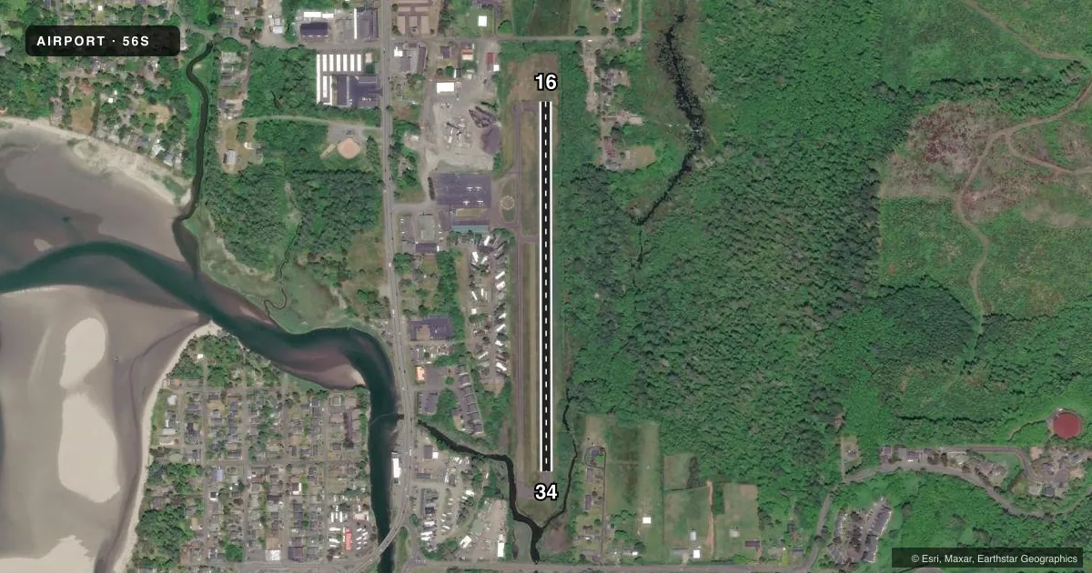
Airport sketch
Runways drawn to scale from FAA survey coordinates, rendered over satellite imagery. Not for navigation.
Approaches & charts
Services on the field
Fuel grades, oxygen, maintenance, ramp storage and lighting — as declared to the FAA by the airport operator.
Fuel & services
- Fuel
- Not available
- Oxygen (bottled)
- Not available
- Oxygen (bulk)
- Not available
- Airframe repair
- Not available
- Power plant repair
- Not available
Ramp & ground
- Transient storage
- Tie-down
- Landing fee
- No fee published
- Customs
- Not available
- Lighting schedule
- SEE RMK
- Beacon schedule
- SS-SR
- Beacon
- White / Green (civil land)(WG)
- Wind indicator
- Lighted
- Segmented circle
- Yes
Fuel & FBOs
Cheapest 100LL and Jet A on the field and nearby. Always confirm with the FBO before taxi.
Airport notes
Surface conditions, obstructions, local procedures, lighting outages and other notes published with each FAA cycle.
General notes
- BIRDS AND ELK ON & INVOF RWY.
- FOR CD CTC SEATTLE ARTCC AT 253-351-3694.
Lighting notes
- ACTVT MIRL RWY 16/34 CTAF.
Approach & departure obstructions
- 1630' BRUSHLINE FROM 0-200' AT 110' LEFT OF CENTERLINE
- 34RWY 34 +25' TREES 0-100' FM THLD 80-100' R.
- 1629:1 FROM DISPLACED THRESHOLD
VFR map & nearby airports
VFR sectional. Tap any ICAO chip to open that airport.
Key facts · 56S
Answer card- ICAO
- 56S
- Name
- SEASIDE MUNI
- Location
- SEASIDE, OREGON
- Elevation
- 12 ft MSL
- Traffic pattern altitude
- 1,012 ft MSL (1,000 AGL)
- Control tower
- Non-towered (use CTAF)
- Total runways
- 1
- Longest runway
- 16/34 · 2,211 ft
- Published ILS approaches
- 0
- Published frequencies
- 1
- Magnetic variation
- 20°
- Current flight rules
- MVFR
- Current wind
- 200° at 8 kt
- Favored runway now
- RWY 16
Seaside Muni sits in Seaside, Oregon. Field elevation is 12 ft MSL. The airport has one runway. Runway 16/34 is 2,211 ft long and asphalt. There is no control tower. CTAF is 122.9. No ILS approaches are published here.
Pattern altitude is not published. Use 1,000 ft AGL for light piston traffic unless the current Chart Supplement says otherwise. The published runway lights on 16/34 are medium intensity and are activated by CTAF. That helps for night ops. You still need to be ready to self-announce clearly on CTAF.
The published remarks matter here. There is a 30-foot brushline near runway 16. It sits left of centerline close to the threshold. Runway 16 also has a 29:1 obstacle clearance slope from the displaced threshold. Runway 34 has 25-foot trees near the threshold on the right side. Birds and elk are reported on and near the runway. For a first visit, plan for a short coastal strip with wildlife and obstacle awareness. Check the current FAA Chart Supplement for any noise or curfew restrictions before flying into the field. If you need clearance delivery, Seattle ARTCC is listed in the remarks.