METAR & TAF KAST
Current METAR
Observed 10:55Z
KAST 271055Z AUTO 15004KT 10SM OVC021 15/12 A3007 RMK AO2 SLP181 T01500122 $
- Wind
- 150° @ 4 kt
- Visibility
- 10 SM
- Temp / Dew
- 15°C / 12°C
- Altimeter
- 30.07 inHg
- Clouds
- OVC
- Density alt
- -168 ft
- Ceiling
- 2,100 ft AGL
- Rules
- MVFR
Airport info & contacts
Manager on record, flight service, ARTCC, attendance schedule and pattern altitude — published by the FAA and refreshed every 28 days.
Location
- From city
- 3 NM SW
- VFR sectional
- SEATTLE
- ARTCC
- ZSE · SEATTLE
- NOTAM facility
- AST (NOTAM-D)
Airport manager
- Name
- MATT MCGRATH
- Phone
- 503-298-0909
- Address
- 422 GATEWAY AVENUE, SUITE 100, ASTORIA OR 97103
Flight service · Hours
- FSS MMV
- MC MINNVILLE1-800-WX-BRIEF
- Attendance
- 0800-1700
Frequencies
Tap any row to copy the frequency to your clipboard.
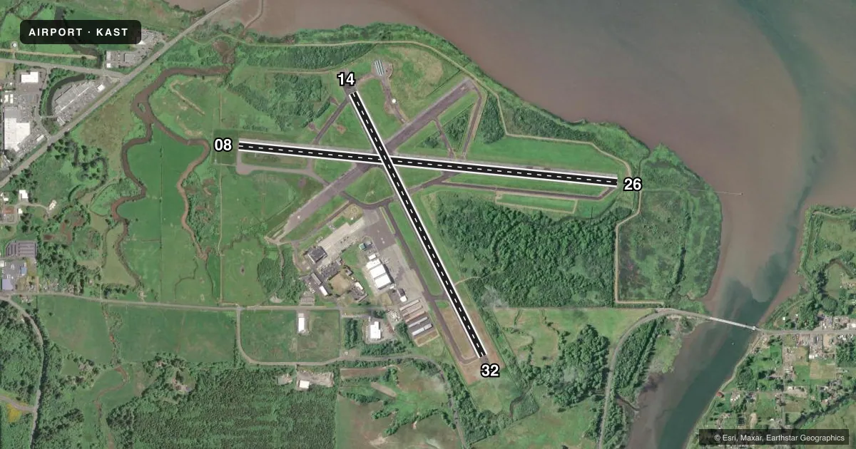
Runways & pattern
Full pagePattern entry · RWY 14
LEFT TRAFFIC| Runway | Heading (°M) | Length | Surface | Traffic |
|---|---|---|---|---|
| 08/26 | 80° / 260° | 5,794 ft | ASPH | Standard L |
| 14/32Favored | 139° / 319° | 4,467 ft | ASPH | Standard L |
Runway end performance
| End | TORA | TODA | ASDA | LDA | VGSI | Approach lights | Obstruction |
|---|---|---|---|---|---|---|---|
| 08 | 5,794' | 5,794' | 5,194' | 4,894' | VASI 4-box left(3°) | — | 116', tree, 3100' from thr, 900' R of cntrln, slope 25 |
| 26 | 5,794' | 5,794' | 5,494' | 4,780' | — | MALSR | 12', fence, 200' from thr, 50' R of cntrln, slope 0 |
| 14 | 4,467' | 4,467' | 4,467' | 4,467' | VASI 4-box left(3°) | — | 5', berm, 200' from thr, 0' R of cntrln, slope 0 |
| 32 | 4,467' | 4,467' | 4,467' | 4,467' | PAPI 4-box left(4°) | — | — |
Declared distances in feet. TORA = takeoff run available, TODA = takeoff distance, ASDA = accelerate-stop, LDA = landing distance.
Airport sketch
Runways drawn to scale from FAA survey coordinates, rendered over satellite imagery. Not for navigation.
Approaches & charts
ILS · 1
Services on the field
Fuel grades, oxygen, maintenance, ramp storage and lighting — as declared to the FAA by the airport operator.
Fuel & services
- Fuel
- 100LLAA+
- Oxygen (bottled)
- Not available
- Oxygen (bulk)
- Not available
- Airframe repair
- Major
- Power plant repair
- Minor
- Other services
- AFRT,AMB,CARGO,INSTR,RNTL
Ramp & ground
- Transient storage
- Tie-down
- Landing fee
- No fee published
- Customs
- Not available
- Lighting schedule
- SEE RMK
- Beacon schedule
- SS-SR
- Beacon
- White / Green (civil land)(WG)
- Wind indicator
- Lighted
- Segmented circle
- Yes
Fuel & FBOs
Cheapest 100LL and Jet A on the field and nearby. Always confirm with the FBO before taxi.
Airport notes
Surface conditions, obstructions, local procedures, lighting outages and other notes published with each FAA cycle.
General notes
- MIGRATORY FLOCKS OF WATERFOWL ON & INVOF ARPT.
- HIGH CONCENTRATION HEL OPNS IN AREA.
- (E94) SAWRS.
- RWY 14/32 HAS BASIC MARKINGS WITH SIDE STRIPES.
- FOR CD IF UNA TO CTC ON FSS FREQ, CTC SEATTLE ARTCC AT 253-351-3694.
- USCG ASTORIA AIR 345.0.
- SERVICE FUEL: PORT OF ASTORIA, AVBL 1600-0100Z-, C503-861-1222. OT C503-298-7531, $50 FEE
Lighting notes
- ACTVT MIRL RWY 08/26 & RY 14/32, MALSR RWY 26 AND REIL RWY 08 - CTAF.
Fuel notes
- 100LLMIL FUEL AVBL ON GEN AVN/FBO RAMP, US GOVT AIRCARD ACPTD. CTC ASTORIA MAINT CTL 171.35 15 MIN PRIOR TO ENTERING CG RAMP. C503-861-6288.
Approach & departure obstructions
- 145 FT LEVEE 150 FT FROM RY END 250 FT L TO 250 FT R.
- 14APCH SLOPE 21:1 TO DSPLCD THR.
- 26+4 FT LEVEE DIST 350 FT 500 FT R, +50:1 BASED ON DSPLCD THR.
Other notes
- ESTABD PRIOR TO 1959.
- 1FOR FUEL OUTSIDE NML WORKING HRS CTC FBO 503-298-7531.
VFR map & nearby airports
VFR sectional. Tap any ICAO chip to open that airport.
Key facts · KAST
Answer card- ICAO
- KAST
- Name
- ASTORIA RGNL
- Location
- ASTORIA, OREGON
- Elevation
- 14.7 ft MSL
- Traffic pattern altitude
- 1,014.7 ft MSL (1,000 AGL)
- Control tower
- Non-towered (use CTAF)
- Total runways
- 2
- Longest runway
- 08/26 · 5,794 ft
- Published ILS approaches
- 1
- Published frequencies
- 2
- Magnetic variation
- 15°
- Current flight rules
- MVFR
- Current wind
- 150° at 4 kt
- Favored runway now
- RWY 14
Astoria Regional Airport sits in Astoria, Oregon near the mouth of the Columbia River. Field elevation is 14.7 ft MSL. The airport has two asphalt runways. The longest is 08/26 at 5,794 ft. The field is not towered. CTAF and UNICOM are both 122.8. The published pattern altitude is not listed, so use the standard 1,000 ft AGL for light piston traffic unless the current Chart Supplement says otherwise.
Runway 26 has an ILS. Medium intensity runway lights are on both runways. The approach lighting system with runway alignment indicator lights is on runway 26. Runway end identifier lights are on runway 08. They are activated via CTAF. That matters here because the field has a lot of helicopter activity in the area. Expect to stay alert in the pattern and on the taxiways.
Astoria Regional Airport is on the field and carries 100LL, Jet A and Jet A Prist. Fuel service is provided by the Port of Astoria. Published remarks say fuel service is available from 1600 to 0100 Zulu. A $50 fee applies. For after-hours fuel, call the FBO directly. Runway 26 also has a levee near the departure end. Check the current Chart Supplement before you go, especially if you need clearance help or are planning a night arrival.