METAR & TAF 14S
14S does not publish a METAR.
Showing the nearest reporting station: KHQM (BOWERMAN FLD) · 8.1 NM away. Conditions at 14S may differ.
METAR · KHQM
Observed 10:24Z
KHQM 271024Z AUTO 11006KT 10SM BKN014 OVC022 15/13 A3006 RMK AO2 T01500133
- Wind
- 110° @ 6 kt
- Visibility
- 10 SM
- Temp / Dew
- 15°C / 13°C
- Altimeter
- 30.06 inHg
- Clouds
- OVC
- Density alt
- -156 ft
- Ceiling
- 1,400 ft AGL
- Rules
- MVFR
Airport info & contacts
Manager on record, flight service, ARTCC, attendance schedule and pattern altitude — published by the FAA and refreshed every 28 days.
Location
- From city
- 1 NM N
- VFR sectional
- SEATTLE
- ARTCC
- ZSE · SEATTLE
- NOTAM facility
- SEA (NOTAM-D)
Airport manager
- Name
- THOMAS CAPPA
- Phone
- 360-268-0131
- Address
- PO BOX 505, 604 NORTH MONTESANO STREET, WESTPORT WA 98595
Flight service · Hours
- FSS SEA
- SEATTLE1-800-WX-BRIEF
- Attendance
- Unattended
Frequencies
Tap any row to copy the frequency to your clipboard.
Runways & pattern
Full pagePattern entry · RWY 12
LEFT TRAFFICRunway end performance
| End | TORA | TODA | ASDA | LDA | VGSI | Approach lights | Obstruction |
|---|---|---|---|---|---|---|---|
| 12 | — | — | — | — | PAPI 2-box left | — | 26', trees, 406' from thr, 43' R of cntrln, slope 7 |
| 30 | — | — | — | — | PAPI 2-box left | — | — |
Declared distances in feet. TORA = takeoff run available, TODA = takeoff distance, ASDA = accelerate-stop, LDA = landing distance.
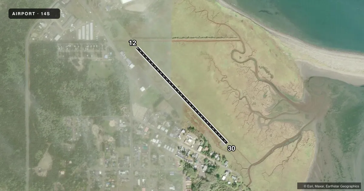
Airport sketch
Runways drawn to scale from FAA survey coordinates, rendered over satellite imagery. Not for navigation.
Approaches & charts
Services on the field
Fuel grades, oxygen, maintenance, ramp storage and lighting — as declared to the FAA by the airport operator.
Fuel & services
- Fuel
- Not available
- Oxygen (bottled)
- Not available
- Oxygen (bulk)
- Not available
- Airframe repair
- Not available
- Power plant repair
- Not available
Ramp & ground
- Transient storage
- Tie-down
- Landing fee
- No fee published
- Customs
- Not available
- Lighting schedule
- SS-SR
- Beacon schedule
- SS-SR
- Beacon
- White / Green (civil land)(WG)
- Wind indicator
- Lighted
- Segmented circle
- Yes
Fuel & FBOs
Cheapest 100LL and Jet A on the field and nearby. Always confirm with the FBO before taxi.
Airport notes
Surface conditions, obstructions, local procedures, lighting outages and other notes published with each FAA cycle.
General notes
- LARGE BIRD NESTING AREA ADJ TO RY 12/30.
- FOR CD CTC SEATTLE ARTCC AT 253-351-3694.
- DEER ON & INVOF RWY.
- 12 FT SLOPE 16 FT FM BOTH SIDES OF RWY.
Approach & departure obstructions
- 1215 FT TREES, 150 FT DSTC, 75 FT L.
- 12ADDITIONAL OBSTN 34 FT POLES, 1050 FT DSTC 0B, 25:1.
Other notes
- ESTABD PRIOR TO MAY 15 1959.
- PILOTS BRING OWN ROPES.
- MANAGERPUBLIC WORKS DIRECTOR.
- MANAGERALSO, 360-268-9091 STREET DEPT.
- 12/30SOFT SHOULDERS.
VFR map & nearby airports
VFR sectional. Tap any ICAO chip to open that airport.
Key facts · 14S
Answer card- ICAO
- 14S
- Name
- WESTPORT
- Location
- WESTPORT, WASHINGTON
- Elevation
- 14 ft MSL
- Traffic pattern altitude
- 1,014 ft MSL (1,000 AGL)
- Control tower
- Non-towered (use CTAF)
- Total runways
- 1
- Longest runway
- 12/30 · 2,318 ft
- Published ILS approaches
- 0
- Published frequencies
- 1
- Magnetic variation
- 20°
- Current flight rules
- MVFR
- Current wind
- 110° at 6 kt
- Favored runway now
- RWY 12
Westport Airport (14S) sits in Westport, Washington. Field elevation is 14 ft MSL. The airport has one runway. Runway 12/30 is 2,318 ft long and asphalt. There is no control tower. CTAF is 122.9.
No ILS approaches are published here. Pattern altitude is not published in the facts, so use the standard 1,000 ft AGL for light piston traffic unless the current FAA Chart Supplement says otherwise. With a low field elevation and a coastal setting, watch the wind and the surface conditions closely. The published remarks also call out large bird activity near the runway, deer on and near the runway, soft shoulders on 12/30, a slope close to both sides of the pavement. There are also obstructions noted off the departure end of runway 12.
No on-field FBOs are listed in the facts. Plan on verifying services with the airport operator or the FBO directly by phone before you go. For clearance delivery, the published remarks direct pilots to Seattle ARTCC at 253-351-3694. If you are flying in for the first time, treat this as a small uncontrolled field with some wildlife and terrain-related caution points right on the runway environment.