METAR & TAF KHQM
Current METAR
Observed 05:53Z
KHQM 270553Z AUTO 10004KT 10SM OVC023 16/14 A3008 RMK AO2 SLP189 60001 T01560139 10161 20156 56000
- Wind
- 100° @ 4 kt
- Visibility
- 10 SM
- Temp / Dew
- 16°C / 14°C
- Altimeter
- 30.08 inHg
- Clouds
- OVC
- Density alt
- -56 ft
- Ceiling
- 2,300 ft AGL
- Rules
- MVFR
Airport info & contacts
Manager on record, flight service, ARTCC, attendance schedule and pattern altitude — published by the FAA and refreshed every 28 days.
Location
- From city
- 2 NM W
- VFR sectional
- SEATTLE
- ARTCC
- ZSE · SEATTLE
- NOTAM facility
- HQM (NOTAM-D)
Airport manager
- Name
- SHANNON ANDERSON
- Phone
- 360-533-9544
- Address
- BOX 660, 111 S WOODING STREET, ABERDEEN WA 98520
Flight service · Hours
- FSS SEA
- SEATTLE1-800-WX-BRIEF
- Attendance
- Unattended
Frequencies
Tap any row to copy the frequency to your clipboard.
Runways & pattern
Full pagePattern entry · RWY 06
RIGHT TRAFFICRunway end performance
| End | TORA | TODA | ASDA | LDA | VGSI | Approach lights | Obstruction |
|---|---|---|---|---|---|---|---|
| 06 | — | — | — | — | PAPI 4-box right(3°) | — | — |
| 24 | — | — | — | — | PAPI 4-box left(3.5°) | MALSR | — |
Declared distances in feet. TORA = takeoff run available, TODA = takeoff distance, ASDA = accelerate-stop, LDA = landing distance.
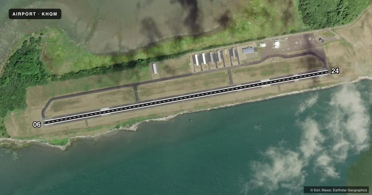
Airport sketch
Runways drawn to scale from FAA survey coordinates, rendered over satellite imagery. Not for navigation.
Approaches & charts
ILS · 1
Services on the field
Fuel grades, oxygen, maintenance, ramp storage and lighting — as declared to the FAA by the airport operator.
Fuel & services
- Fuel
- 100LLA
- Oxygen (bottled)
- Not available
- Oxygen (bulk)
- Not available
- Airframe repair
- Not available
- Power plant repair
- Not available
- Other services
- AMB
Ramp & ground
- Transient storage
- Tie-down
- Landing fee
- No fee published
- Customs
- Not available
- Lighting schedule
- SEE RMK
- Beacon schedule
- SS-SR
- Beacon
- White / Green (civil land)(WG)
- Wind indicator
- Lighted
- Segmented circle
- Yes
Fuel & FBOs
Cheapest 100LL and Jet A on the field and nearby. Always confirm with the FBO before taxi.
Airport notes
Surface conditions, obstructions, local procedures, lighting outages and other notes published with each FAA cycle.
General notes
- <FLOCKS OF WATERFOWL ON AND IN VCNTY ARPT. CAUTION ADZD.
- SERVICE ROAD SOUTH OF RY IN PRIMARY SURFACE.
- ULTRALIGHTS PROHIBITED WITHOUT WRITTEN PERMISSON FROM ARPT MGR.
- 103 FT CRANE 0.2 NM SW OF AER RY 24.
- FOR CD IF UNA TO CTC ON FSS FREQ, CTC SEATTLE ARTCC AT 253-351-3694.
Lighting notes
- ACTVT HIRL RY 06/24, PAPI RWY 06/24, MALSR RY 24 & REIL RY 06 - CTAF.
Fuel notes
- 100LL100LL AND JET A AVBL 24 HRS A DAY WITH MAJOR CREDIT CARD.
Approach & departure obstructions
- 06MRKGS FADED.
- 24MRKGS FADED.
Other notes
- THIS AIRPORT HAS BEEN SURVEYED BY THE NATIONAL GEODETIC SURVEY.
- ESTABD PRIOR TO 1959.
- MANAGERAMGR CELL 360-310-0201.
VFR map & nearby airports
VFR sectional. Tap any ICAO chip to open that airport.
Key facts · KHQM
Answer card- ICAO
- KHQM
- Name
- BOWERMAN FLD
- Location
- HOQUIAM, WASHINGTON
- Elevation
- 17.8 ft MSL
- Traffic pattern altitude
- 1,017.8 ft MSL (1,000 AGL)
- Control tower
- Non-towered (use CTAF)
- Total runways
- 1
- Longest runway
- 06/24 · 5,000 ft
- Published ILS approaches
- 1
- Published frequencies
- 2
- Magnetic variation
- 19°
- Current flight rules
- MVFR
- Current wind
- 100° at 4 kt
- Favored runway now
- RWY 06
Bowerman Fld sits in Hoquiam, Washington. The field elevation is 17.8 ft MSL. It has one runway, 06/24, at 5,000 ft. There is no control tower. CTAF and UNICOM are both 122.7. The published ILS serves runway 24. Pattern altitude is not published, so use the standard 1,000 ft AGL for light piston traffic unless the current Chart Supplement says otherwise.
Bowerman Airport is the on-field FBO. It carries Jet A and 100LL. Fuel is available 24 hours a day with a major credit card. The airport has high intensity runway lighting on 06/24. PAPI is installed on both ends. Runway 24 also has MALSR. REIL is installed on runway 06. That makes night and IFR work more straightforward, but the field still deserves a careful look. There is a 103 ft crane about 0.2 NM southwest of the airport near runway 24. Waterfowl are reported on and near the airport. Expect that to matter on arrival and departure. A service road also sits south of the runway in the primary surface area. Ultralight aircraft are prohibited without written permission from the airport manager. For clearance delivery help, the Chart Supplement notes Seattle ARTCC contact if FSS cannot be reached.