METAR & TAF S16
S16 does not publish a METAR.
Showing the nearest reporting station: KHQM (BOWERMAN FLD) · 14.7 NM away. Conditions at S16 may differ.
METAR · KHQM
Observed 12:53Z
KHQM 271253Z AUTO 11006KT 10SM OVC011 15/13 A3006 RMK AO2 SLP184 T01500133
- Wind
- 110° @ 6 kt
- Visibility
- 10 SM
- Temp / Dew
- 15°C / 13°C
- Altimeter
- 30.06 inHg
- Clouds
- OVC
- Density alt
- -172 ft
- Ceiling
- 1,100 ft AGL
- Rules
- MVFR
Airport info & contacts
Manager on record, flight service, ARTCC, attendance schedule and pattern altitude — published by the FAA and refreshed every 28 days.
Location
- From city
- 2 NM NW
- VFR sectional
- SEATTLE
- ARTCC
- ZSE · SEATTLE
- NOTAM facility
- SEA (NOTAM-D)
Airport manager
- Name
- JOHN WILSON
- Phone
- 360-618-2477
- Address
- PO BOX 47312, OLYMPIA WA 98504-7264
Flight service · Hours
- FSS SEA
- SEATTLE1-800-WX-BRIEF
- Attendance
- Unattended
Frequencies
Tap any row to copy the frequency to your clipboard.
Runways & pattern
Full pagePattern entry · RWY 14
RIGHT TRAFFICRunway end performance
| End | TORA | TODA | ASDA | LDA | VGSI | Approach lights | Obstruction |
|---|---|---|---|---|---|---|---|
| 14 | — | — | — | — | — | — | 2', other, 0' from thr, 0' R of cntrln, slope 0 |
Declared distances in feet. TORA = takeoff run available, TODA = takeoff distance, ASDA = accelerate-stop, LDA = landing distance.
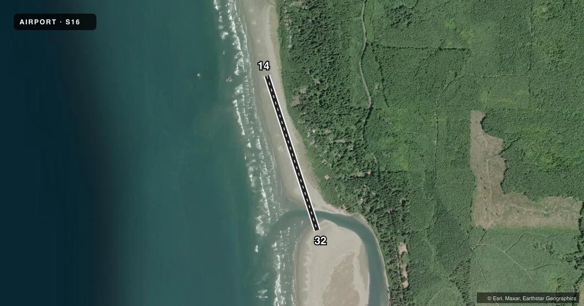
Airport sketch
Runways drawn to scale from FAA survey coordinates, rendered over satellite imagery. Not for navigation.
Approaches & charts
Services on the field
Fuel grades, oxygen, maintenance, ramp storage and lighting — as declared to the FAA by the airport operator.
Fuel & services
- Fuel
- Not available
- Oxygen (bottled)
- Not available
- Oxygen (bulk)
- Not available
- Airframe repair
- Not available
- Power plant repair
- Not available
Ramp & ground
- Transient storage
- Not published
- Landing fee
- No fee published
- Wind indicator
- Yes
- Segmented circle
- No
Fuel & FBOs
Cheapest 100LL and Jet A on the field and nearby. Always confirm with the FBO before taxi.
Airport notes
Surface conditions, obstructions, local procedures, lighting outages and other notes published with each FAA cycle.
General notes
- RY AVBL WHEN TIDE IS LOW.
- VEHICLES, PEDESTRIANS & ANIMALS ON & INVOF RY.
Approach & departure obstructions
- 14ROCK
Other notes
- EXISTED PRIOR TO 1959.
- 1ARPT CLSD TO VEHICLES APRIL 15 THRU THE DAY AFTER LABOR DAY.
VFR map & nearby airports
VFR sectional. Tap any ICAO chip to open that airport.
Key facts · S16
Answer card- ICAO
- S16
- Name
- COPALIS STATE
- Location
- COPALIS, WASHINGTON
- Elevation
- 1 ft MSL
- Traffic pattern altitude
- 1,001 ft MSL (1,000 AGL)
- Control tower
- Non-towered (use CTAF)
- Total runways
- 1
- Longest runway
- 14/32 · 3,560 ft
- Published ILS approaches
- 0
- Published frequencies
- 1
- Magnetic variation
- 20°
- Current flight rules
- MVFR
- Current wind
- 110° at 6 kt
- Favored runway now
- RWY 14
Copalis State Airport is in Copalis, Washington. The field elevation is 1 ft MSL. It has one runway, 14/32, which is 3,560 ft long and surfaced with sand. No tower is published here. CTAF is 122.9. No ILS approaches are published.
The runway is available when the tide is low. That matters here more than at most strips. The airport also has a rock obstruction near runway 14. Vehicles, pedestrians and animals may be on or near the runway. The airport is closed to vehicles from April 15 through the day after Labor Day. This is a low-elevation coastal strip, so tide timing and runway condition should be part of your preflight planning.
Pattern altitude is not published. Use the standard 1,000 ft AGL for light piston operations unless the current FAA Chart Supplement says otherwise. There are no on-field FBOs listed, so plan on confirming services with the airport operator before you go. For a first visit, treat this as a short-field coastal landing with active surface and access issues. Check the current FAA Chart Supplement for any local notes before departure.