METAR & TAF KSHN
Current METAR
Observed 14:53Z
KSHN 271453Z AUTO 24004KT 10SM OVC016 16/13 A3006 RMK AO2 SLP181 T01560133 53005 $
- Wind
- 240° @ 4 kt
- Visibility
- 10 SM
- Temp / Dew
- 16°C / 13°C
- Altimeter
- 30.06 inHg
- Clouds
- OVC
- Density alt
- 285 ft
- Ceiling
- 1,600 ft AGL
- Rules
- MVFR
Airport info & contacts
Manager on record, flight service, ARTCC, attendance schedule and pattern altitude — published by the FAA and refreshed every 28 days.
Location
- From city
- 3 NM NW
- VFR sectional
- SEATTLE
- ARTCC
- ZSE · SEATTLE
- NOTAM facility
- SHN (NOTAM-D)
Airport manager
- Name
- WENDY SMITH- EXECUTIVE DIRECTOR
- Phone
- 360-426-1151
- Address
- 21 WEST SANDERSON WAY, SHELTON WA 98584
Flight service · Hours
- FSS SEA
- SEATTLE1-800-WX-BRIEF
- Attendance
- MON-FRI · 0800-1630
Frequencies
Tap any row to copy the frequency to your clipboard.
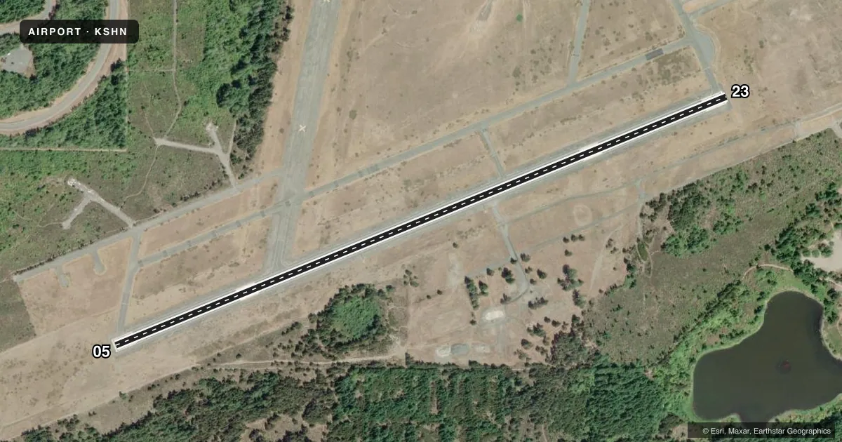
Runways & pattern
Full pagePattern entry · RWY 23
LEFT TRAFFICRunway end performance
| End | TORA | TODA | ASDA | LDA | VGSI | Approach lights | Obstruction |
|---|---|---|---|---|---|---|---|
| 05 | — | — | — | — | — | — | 49', trees, 1053' from thr, 141' R of cntrln, slope 17 |
| 23 | — | — | — | — | PAPI 4-box left(3°) | — | 80', trees, 2298' from thr, 0' R of cntrln, slope 22 |
Declared distances in feet. TORA = takeoff run available, TODA = takeoff distance, ASDA = accelerate-stop, LDA = landing distance.
Airport sketch
Runways drawn to scale from FAA survey coordinates, rendered over satellite imagery. Not for navigation.
Approaches & charts
Services on the field
Fuel grades, oxygen, maintenance, ramp storage and lighting — as declared to the FAA by the airport operator.
Fuel & services
- Fuel
- 100LLA
- Oxygen (bottled)
- Not available
- Oxygen (bulk)
- Not available
- Airframe repair
- Major
- Power plant repair
- Major
- Other services
- CHTR,INSTR,PAJA,RNTL
Ramp & ground
- Transient storage
- Tie-down
- Landing fee
- No fee published
- Customs
- Not available
- Lighting schedule
- SEE RMK
- Beacon schedule
- SS-SR
- Beacon
- White / Green (civil land)(WG)
- Wind indicator
- Lighted
- Segmented circle
- Yes
Fuel & FBOs
Cheapest 100LL and Jet A on the field and nearby. Always confirm with the FBO before taxi.
Airport notes
Surface conditions, obstructions, local procedures, lighting outages and other notes published with each FAA cycle.
General notes
- (E94) SAWRS
- PARACHUTE OPERATIONS ON THE FIELD AVOID CROSSING MIDFIELD TO ENTER TRAFFIC PATTERN.
- FOR CD CTC SEATTLE APCH AT 206-214-4723.
Lighting notes
- BCN ON WATER TWR NORTH OF RY.
- ACTVT REIL RWY 23; PAPI RWY 23; MIRL RWY 05/23 - CTAF.
Fuel notes
- 100LL24 HR CREDIT CARD FUEL FAC.
Other notes
- ESTABD PRIOR TO 1959.
- PILOTS BRING OWN ROPES.
VFR map & nearby airports
VFR sectional. Tap any ICAO chip to open that airport.
Key facts · KSHN
Answer card- ICAO
- KSHN
- Name
- SANDERSON FLD
- Location
- SHELTON, WASHINGTON
- Elevation
- 272.9 ft MSL
- Traffic pattern altitude
- 1,272.9 ft MSL (1,000 AGL)
- Control tower
- Non-towered (use CTAF)
- Total runways
- 1
- Longest runway
- 05/23 · 5,005 ft
- Published ILS approaches
- 0
- Published frequencies
- 4
- Magnetic variation
- 15°
- Current flight rules
- MVFR
- Current wind
- 240° at 4 kt
- Favored runway now
- RWY 23
Sanderson Fld sits in Shelton, Washington. Field elevation is 272.9 ft MSL. The airport has one runway. Runway 05/23 is 5,005 ft long and asphalt. There is no control tower. Traffic pattern altitude is not published. Use the standard 1,000 ft AGL for light piston traffic unless local instructions say otherwise. No ILS approaches are published here.
Pacific Aero is on the field. It carries 100LL and Jet A. The remarks also note a 24-hour credit card fuel facility. That is useful for late arrivals. Verify current access details before you go. The field uses CTAF 122.8. UNICOM is also 122.8. Seattle Approach handles approach and departure services on 121.1 or 290.9. For clearance delivery, the published number is Seattle Approach at 206-214-4723.
A few operational notes matter here. Parachute operations occur on the field. Avoid crossing midfield to enter the traffic pattern. The beacon is on the water tower north of the runway. Runway end identifier lights are on runway 23. Precision approach path indicators are also on runway 23. Medium intensity runway lights are on both runway ends. They are controlled by CTAF. Pilots should plan for a non-towered pattern and keep a close eye out for jump traffic.