METAR & TAF KUIL
Current METAR
Observed 14:51Z
KUIL 271451Z AUTO 17004KT 3SM -RA BR OVC006 15/14 A3003 RMK AO2 P0005
- Wind
- 170° @ 4 kt
- Visibility
- 3 SM
- Temp / Dew
- 15°C / 14°C
- Altimeter
- 30.03 inHg
- Clouds
- OVC
- Density alt
- 104 ft
- Ceiling
- 600 ft AGL
- Rules
- IFR
Airport info & contacts
Manager on record, flight service, ARTCC, attendance schedule and pattern altitude — published by the FAA and refreshed every 28 days.
Location
- From city
- 7 NM E
- VFR sectional
- SEATTLE
- ARTCC
- ZSE · SEATTLE
- NOTAM facility
- UIL (NOTAM-D)
Airport manager
- Name
- ROD FLECK
- Phone
- 360-374-5412
- Address
- 500 EAST DIVISION ST., FORKS WA 98331
Flight service · Hours
- FSS SEA
- SEATTLE1-800-WX-BRIEF
- Attendance
- Unattended
Frequencies
Tap any row to copy the frequency to your clipboard.
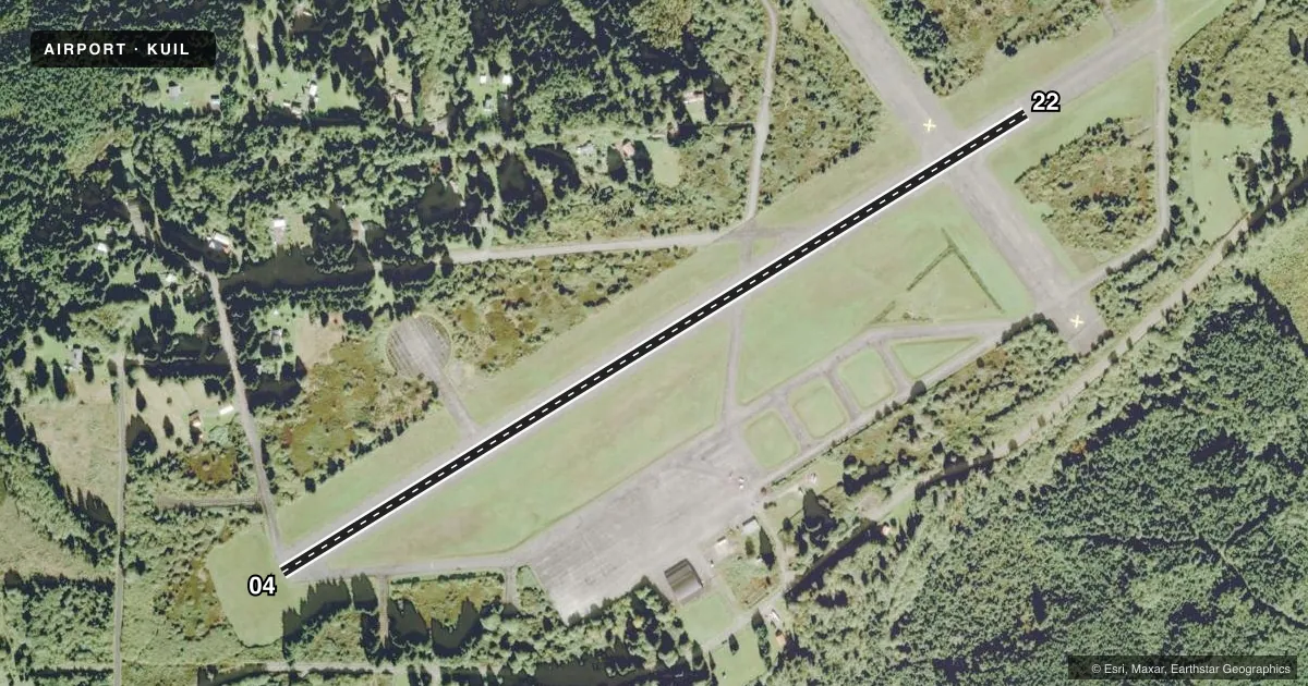
Runways & pattern
Full pagePattern entry · RWY 22
LEFT TRAFFICRunway end performance
| End | TORA | TODA | ASDA | LDA | VGSI | Approach lights | Obstruction |
|---|---|---|---|---|---|---|---|
| 04 | — | — | — | — | — | — | 70', trees, 1535' from thr, 0' R of cntrln, slope 19 |
Declared distances in feet. TORA = takeoff run available, TODA = takeoff distance, ASDA = accelerate-stop, LDA = landing distance.
Airport sketch
Runways drawn to scale from FAA survey coordinates, rendered over satellite imagery. Not for navigation.
Approaches & charts
Services on the field
Fuel grades, oxygen, maintenance, ramp storage and lighting — as declared to the FAA by the airport operator.
Fuel & services
- Fuel
- Not available
- Oxygen (bottled)
- Not available
- Oxygen (bulk)
- Not available
- Airframe repair
- Not available
- Power plant repair
- Not available
Ramp & ground
- Transient storage
- Tie-down
- Landing fee
- No fee published
- Customs
- Not available
- Wind indicator
- Yes
- Segmented circle
- Yes
Fuel & FBOs
Cheapest 100LL and Jet A on the field and nearby. Always confirm with the FBO before taxi.
Airport notes
Surface conditions, obstructions, local procedures, lighting outages and other notes published with each FAA cycle.
General notes
- PEDESTRIANS; VEHICLES & ANIMALS ON & INVOF RY.
- 4 FT SQUARE GRATED DRAIN ON N SIDE OF APRON.
- FOR CD CTC SEATTLE ARTCC AT 253-351-3694.
Other notes
- ESTABD PRIOR 1959.
- PILOTS BRING OWN TIEDOWNS.
- OWNEREXT 245.
VFR map & nearby airports
VFR sectional. Tap any ICAO chip to open that airport.
Key facts · KUIL
Answer card- ICAO
- KUIL
- Name
- QUILLAYUTE
- Location
- QUILLAYUTE, WASHINGTON
- Elevation
- 194.1 ft MSL
- Traffic pattern altitude
- 1,194.1 ft MSL (1,000 AGL)
- Control tower
- Non-towered (use CTAF)
- Total runways
- 1
- Longest runway
- 04/22 · 4,211 ft
- Published ILS approaches
- 0
- Published frequencies
- 1
- Magnetic variation
- 21°
- Current flight rules
- IFR
- Current wind
- 170° at 4 kt
- Favored runway now
- RWY 22
Quillayute Airport (KUIL) sits in Quillayute, Washington on the Olympic Peninsula. Field elevation is 194.1 ft MSL. The airport has one runway, 04/22, which is 4,211 ft long. There is no control tower. CTAF is 122.9. No ILS approaches are published here.
The pattern altitude is not published. Use 1,000 ft AGL for light piston traffic unless the current Chart Supplement says otherwise. The field is a simple setup. The published remarks matter. There is a 4 foot square grated drain on the north side of the apron. Pilots must bring their own tiedowns. Pedestrians, vehicles and animals may be on or near the runway. Keep a sharp scan on taxi and final. For clearance delivery, Seattle ARTCC can be contacted at 253-351-3694.
There are no on-field FBOs listed. Plan on self-sufficiency for arrival and parking. The runway length is workable for many light aircraft. The coastal location can bring changing weather and lower ceilings. Check the current Chart Supplement and the airport operator before you go if you need current operational details.