METAR & TAF W04
W04 does not publish a METAR.
Showing the nearest reporting station: KHQM (BOWERMAN FLD) · 8.6 NM away. Conditions at W04 may differ.
METAR · KHQM
Observed 12:53Z
KHQM 271253Z AUTO 11006KT 10SM OVC011 15/13 A3006 RMK AO2 SLP184 T01500133
- Wind
- 110° @ 6 kt
- Visibility
- 10 SM
- Temp / Dew
- 15°C / 13°C
- Altimeter
- 30.06 inHg
- Clouds
- OVC
- Density alt
- -155 ft
- Ceiling
- 1,100 ft AGL
- Rules
- MVFR
Airport info & contacts
Manager on record, flight service, ARTCC, attendance schedule and pattern altitude — published by the FAA and refreshed every 28 days.
Location
- From city
- 2 NM NE
- VFR sectional
- SEATTLE
- ARTCC
- ZSE · SEATTLE
- NOTAM facility
- SEA (NOTAM-D)
Airport manager
- Name
- SCOTT ANDERSEN
- Phone
- 360-289-3099
- Address
- 548 POINT BROWN AVE NE, 585 BROWN AVE NW, OCEAN SHORES WA 98569
Flight service · Hours
- FSS SEA
- SEATTLE1-800-WX-BRIEF
- Attendance
- Unattended
Frequencies
Tap any row to copy the frequency to your clipboard.
Runways & pattern
Full pagePattern entry · RWY 15
LEFT TRAFFICRunway end performance
| End | TORA | TODA | ASDA | LDA | VGSI | Approach lights | Obstruction |
|---|---|---|---|---|---|---|---|
| 15 | — | — | — | — | PAPI 2-box left(3°) | — | — |
| 33 | — | — | — | — | PAPI 2-box left(3°) | — | — |
Declared distances in feet. TORA = takeoff run available, TODA = takeoff distance, ASDA = accelerate-stop, LDA = landing distance.
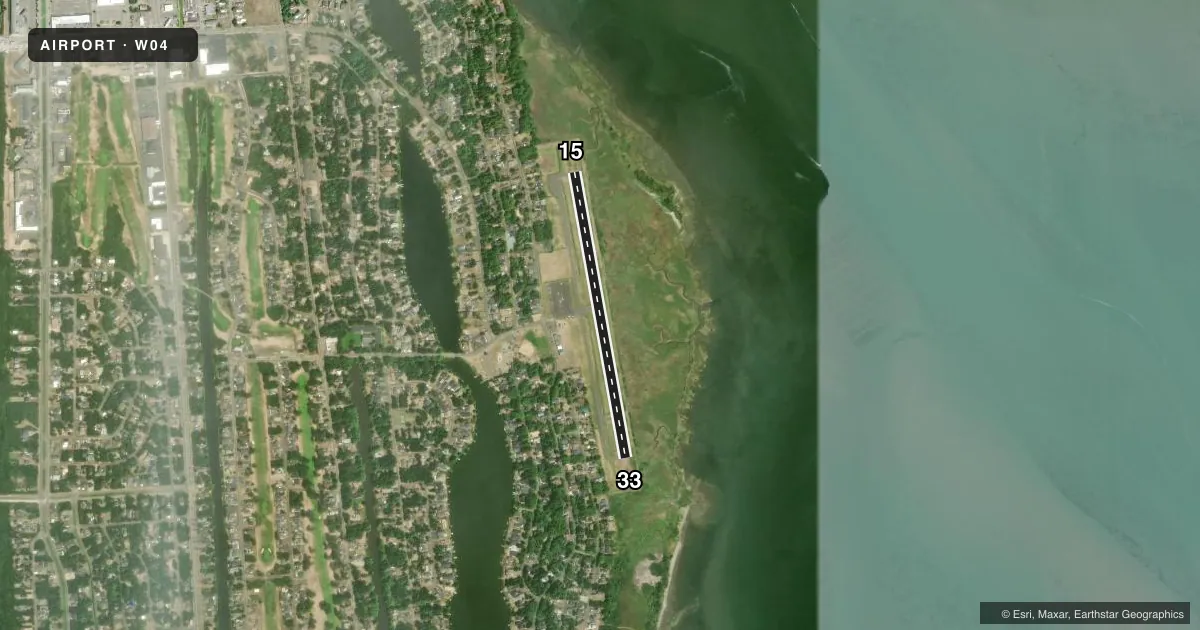
Airport sketch
Runways drawn to scale from FAA survey coordinates, rendered over satellite imagery. Not for navigation.
Approaches & charts
Services on the field
Fuel grades, oxygen, maintenance, ramp storage and lighting — as declared to the FAA by the airport operator.
Fuel & services
- Fuel
- Not available
Ramp & ground
- Transient storage
- Tie-down
- Landing fee
- No fee published
- Lighting schedule
- SEE RMK
- Beacon schedule
- SS-SR
- Beacon
- White / Green (civil land)(WG)
- Wind indicator
- Lighted
- Segmented circle
- Yes
Fuel & FBOs
Cheapest 100LL and Jet A on the field and nearby. Always confirm with the FBO before taxi.
Airport notes
Surface conditions, obstructions, local procedures, lighting outages and other notes published with each FAA cycle.
General notes
- SEABIRDS IN SAFETY & TAXI AREAS AND ADJACENT WETLAND.
- DEER AND BIRDS ON AND INVOF ARPT.
- FOR CD CTC SEATTLE ARTCC AT 253-351-3694.
Lighting notes
- ACTVT MIRL RY 15/33 & PAPI RYS 15 AND 33 - CTAF.
Runway surface & condition
- 15/33HAS ASPH 50 FT WIDE WITH 12.5 FT GRVL SHOLDERS.
VFR map & nearby airports
VFR sectional. Tap any ICAO chip to open that airport.
Key facts · W04
Answer card- ICAO
- W04
- Name
- OCEAN SHORES MUNI
- Location
- OCEAN SHORES, WASHINGTON
- Elevation
- 15 ft MSL
- Traffic pattern altitude
- 1,015 ft MSL (1,000 AGL)
- Control tower
- Non-towered (use CTAF)
- Total runways
- 1
- Longest runway
- 15/33 · 3,100 ft
- Published ILS approaches
- 0
- Published frequencies
- 1
- Magnetic variation
- 20°
- Current flight rules
- MVFR
- Current wind
- 110° at 6 kt
- Favored runway now
- RWY 15
Ocean Shores Muni sits in Ocean Shores, Washington. Field elevation is 15 ft MSL. It has one runway, 15/33 and the longest runway is 3,100 ft. This is an untowered field. CTAF is 122.9.
No ILS approaches are published here. Pattern altitude is not published in the facts, so use the current FAA Chart Supplement before you fly. Runway 15/33 is asphalt 50 feet wide with 12.5 feet of gravel shoulders. Medium intensity runway lights are on 15/33. The PAPI for both runway directions is controlled by CTAF.
For clearance delivery, Seattle ARTCC is listed in the remarks at 253-351-3694. The field also has wildlife notes that matter on rollout and taxi. Seabirds are present in the safety area, taxi areas and the nearby wetland. Deer and birds are also reported on and near the airport. That makes a careful scan on departure and arrival a good habit here. No on-field FBOs are listed. Contact the airport operator directly before arrival or call the field on CTAF for current FBO availability.