METAR & TAF 2S9
2S9 does not publish a METAR.
Showing the nearest reporting station: KHQM (BOWERMAN FLD) · 17.1 NM away. Conditions at 2S9 may differ.
METAR · KHQM
Observed 05:53Z
KHQM 270553Z AUTO 10004KT 10SM OVC023 16/14 A3008 RMK AO2 SLP189 60001 T01560139 10161 20156 56000
- Wind
- 100° @ 4 kt
- Visibility
- 10 SM
- Temp / Dew
- 16°C / 14°C
- Altimeter
- 30.08 inHg
- Clouds
- OVC
- Density alt
- -62 ft
- Ceiling
- 2,300 ft AGL
- Rules
- MVFR
Airport info & contacts
Manager on record, flight service, ARTCC, attendance schedule and pattern altitude — published by the FAA and refreshed every 28 days.
Location
- From city
- 2 NM NW
- VFR sectional
- SEATTLE
- ARTCC
- ZSE · SEATTLE
- NOTAM facility
- SEA (NOTAM-D)
Airport manager
- Name
- JAMES SAYCE
- Phone
- 360-942-3422
- Address
- PORT OF WILLAPA HARBOR, 1725 OCEAN AVENUE, RAYMOND WA 98577
Flight service · Hours
- FSS SEA
- SEATTLE1-800-WX-BRIEF
- Attendance
- Unattended
Frequencies
Tap any row to copy the frequency to your clipboard.
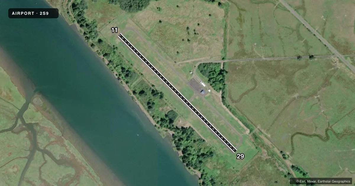
Runways & pattern
Full pagePattern entry · RWY 11
LEFT TRAFFICRunway end performance
| End | TORA | TODA | ASDA | LDA | VGSI | Approach lights | Obstruction |
|---|---|---|---|---|---|---|---|
| 11 | — | — | — | — | — | — | 37', trees, 1045' from thr, 0' R of cntrln, slope 22 |
| 29 | — | — | — | — | — | — | 39', trees, 942' from thr, 125' R of cntrln, slope 19 |
Declared distances in feet. TORA = takeoff run available, TODA = takeoff distance, ASDA = accelerate-stop, LDA = landing distance.
Airport sketch
Runways drawn to scale from FAA survey coordinates, rendered over satellite imagery. Not for navigation.
Approaches & charts
Services on the field
Fuel grades, oxygen, maintenance, ramp storage and lighting — as declared to the FAA by the airport operator.
Fuel & services
- Fuel
- Not available
- Oxygen (bottled)
- Not available
- Oxygen (bulk)
- Not available
- Airframe repair
- Not available
- Power plant repair
- Not available
Ramp & ground
- Transient storage
- Tie-down
- Landing fee
- No fee published
- Customs
- Not available
- Lighting schedule
- SEE RMK
- Beacon schedule
- SEE RMK
- Beacon
- White / Green (civil land)(WG)
- Wind indicator
- Yes
- Segmented circle
- No
Fuel & FBOs
Cheapest 100LL and Jet A on the field and nearby. Always confirm with the FBO before taxi.
Airport notes
Surface conditions, obstructions, local procedures, lighting outages and other notes published with each FAA cycle.
General notes
- BIRDS AND ANIMALS ON AND INVOF ARPT.
- FOR CD CTC SEATTLE ARTCC AT 253-351-3694.
Lighting notes
- ACTVT ROTG BCN - 122.8.
- ACTVT MIRL RY 11/29 - 122.8.
Runway surface & condition
- 11/29NSTD MIRL RY 11/29, LIGHTS 25 FT FROM EDGE.
- 11/29RY IS 52 FT WIDE WITH 22.5 FT ASPH TRTD SHOULDERS.
Other notes
- ESTABD PRIOR TO 5/15/59.
- PILOTS BRING OWN ROPES.
- MANAGEREMERG CTC 360-942-7294.
VFR map & nearby airports
VFR sectional. Tap any ICAO chip to open that airport.
Key facts · 2S9
Answer card- ICAO
- 2S9
- Name
- WILLAPA HARBOR
- Location
- SOUTH BEND/RAYMOND/, WASHINGTON
- Elevation
- 13 ft MSL
- Traffic pattern altitude
- 1,013 ft MSL (1,000 AGL)
- Control tower
- Non-towered (use CTAF)
- Total runways
- 1
- Longest runway
- 11/29 · 3,005 ft
- Published ILS approaches
- 0
- Published frequencies
- 1
- Magnetic variation
- 20°
- Current flight rules
- MVFR
- Current wind
- 100° at 4 kt
- Favored runway now
- RWY 11
Willapa Harbor Airport (2S9) sits near South Bend and Raymond in Washington. Field elevation is 13 ft MSL. The airport has one runway, 11/29, which is 3,005 ft long and asphalt. There is no control tower. CTAF is 122.9.
No ILS approaches are published here. The traffic pattern altitude is not published in the facts, so use the current FAA Chart Supplement before you fly. The published remarks matter here. Runway 11/29 has nonstandard medium intensity lighting. The lights are set 25 feet from the runway edge. The runway is 52 feet wide with asphalt treated shoulders. The beacon is activated on 122.8. Birds and animals are reported on and near the airport. Pilots must bring their own ropes.
There are no on-field FBOs listed in the facts. Contact the airport operator or the FBO directly by phone before arrival if you need fuel or other services. For clearance delivery, Seattle ARTCC is listed in the remarks. This is a low-elevation coastal field, so expect marine weather and changing winds to matter more than terrain. Check the current FAA Chart Supplement for any published noise or curfew restrictions before flying into the field.