METAR & TAF 7W1
7W1 does not publish a METAR.
Showing the nearest reporting station: KAST (ASTORIA RGNL) · 10.8 NM away. Conditions at 7W1 may differ.
METAR · KAST
Observed 17:55Z
KAST 261755Z AUTO 22009G16KT 10SM FEW016 SCT030 OVC040 17/15 A3006 RMK AO2 SLP180 60003 T01720150 10172 20150 51004 $
- Wind
- 220° @ 9G16 kt
- Visibility
- 10 SM
- Temp / Dew
- 17°C / 15°C
- Altimeter
- 30.06 inHg
- Clouds
- OVC
- Density alt
- 83 ft
- Ceiling
- 4,000 ft AGL
- Rules
- VFR
Airport info & contacts
Manager on record, flight service, ARTCC, attendance schedule and pattern altitude — published by the FAA and refreshed every 28 days.
Location
- From city
- 2 NM E
- VFR sectional
- SEATTLE
- ARTCC
- ZSE · SEATTLE
- NOTAM facility
- SEA (NOTAM-D)
Airport manager
- Name
- TINA HAYES
- Phone
- 360-642-3143
- Address
- PO BOX 307, ILWACO WA 98624
Flight service · Hours
- FSS SEA
- SEATTLE1-800-WX-BRIEF
- Attendance
- Unattended
Frequencies
Tap any row to copy the frequency to your clipboard.
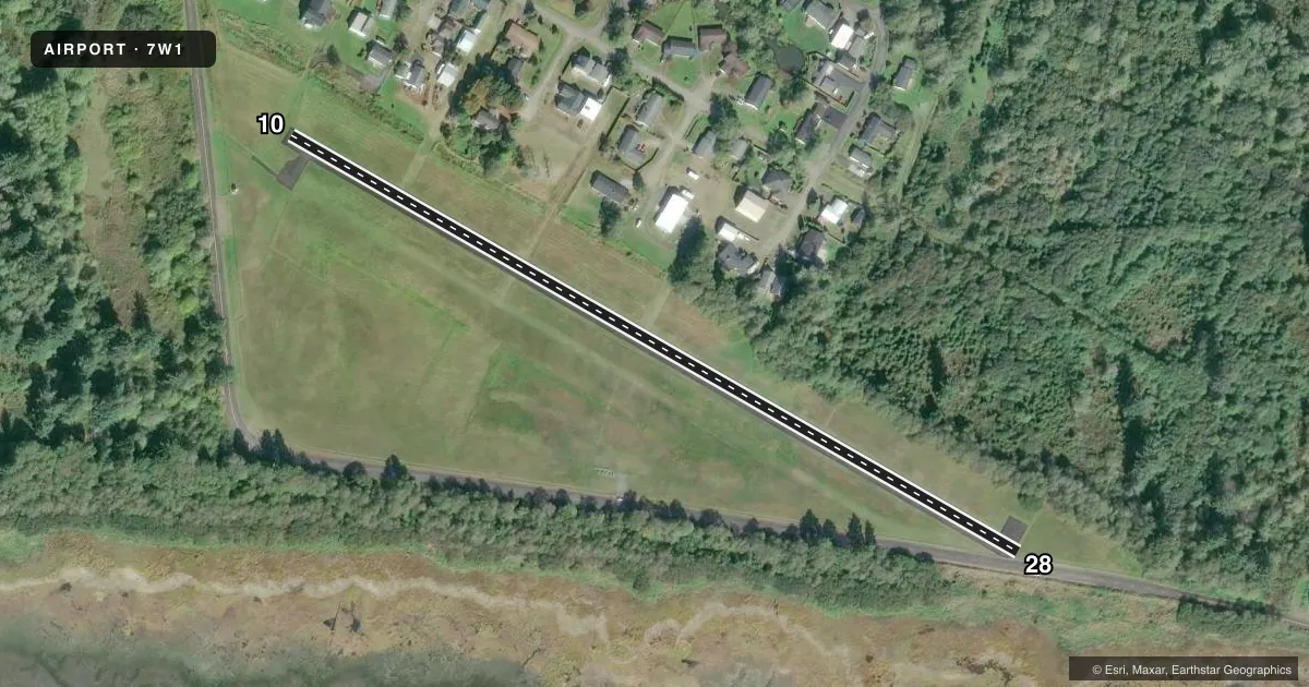
Runways & pattern
Full pagePattern entry · RWY 28
LEFT TRAFFICRunway end performance
| End | TORA | TODA | ASDA | LDA | VGSI | Approach lights | Obstruction |
|---|---|---|---|---|---|---|---|
| 10 | — | — | — | — | — | — | 46', trees, 300' from thr, 88' R of cntrln, slope 2 |
| 28 | — | — | — | — | PAPI 2-box left(4°) | — | 45', trees, 562' from thr, 59' R of cntrln, slope 8 |
Declared distances in feet. TORA = takeoff run available, TODA = takeoff distance, ASDA = accelerate-stop, LDA = landing distance.
Airport sketch
Runways drawn to scale from FAA survey coordinates, rendered over satellite imagery. Not for navigation.
Approaches & charts
Services on the field
Fuel grades, oxygen, maintenance, ramp storage and lighting — as declared to the FAA by the airport operator.
Fuel & services
- Fuel
- Not available
- Oxygen (bottled)
- Not available
- Oxygen (bulk)
- Not available
- Airframe repair
- Not available
- Power plant repair
- Not available
Ramp & ground
- Transient storage
- Tie-down
- Landing fee
- No fee published
- Customs
- Not available
- Beacon schedule
- SEE RMK
- Beacon
- White / Green (civil land)(WG)
- Wind indicator
- Lighted
- Segmented circle
- No
Fuel & FBOs
Cheapest 100LL and Jet A on the field and nearby. Always confirm with the FBO before taxi.
Airport notes
Surface conditions, obstructions, local procedures, lighting outages and other notes published with each FAA cycle.
General notes
- FOR CD CTC SEATTLE ARTCC AT 253-351-3694.
Lighting notes
- ARPT BEACON PILOT ACTIVATED.
Runway surface & condition
- 10/28FULL STRENGTH PAVEMENT CENTER 30' ONLY.
Approach & departure obstructions
- 1015 FT ROAD & 2 FT FENCE, 0-200 FT FM END, 50 FT-125 FT R.
- 28RWY 28 15 FT ROAD 0-200 FT DIST 60 FT L. 2 FT FENCE & 6 FT SIGN 76 FT R & 135 FT FM THR.
- 10MARKINGS FADED.
- 28MARKINGS FADED.
- 28APRCH SLOPE 0:1 AT DSPLCD THLD, OVR 50 FT TREES, 0 FT DSTC, 123 FT R.
- 28RY 28 ALSO 15 FT RD 60 FT LEFT AT RY END.
Other notes
- ESTABD PRIOR TO MAY 1959.
- PILOTS BRING OWN ROPES.
VFR map & nearby airports
VFR sectional. Tap any ICAO chip to open that airport.
Key facts · 7W1
Answer card- ICAO
- 7W1
- Name
- PORT OF ILWACO
- Location
- ILWACO, WASHINGTON
- Elevation
- 13 ft MSL
- Traffic pattern altitude
- 1,013 ft MSL (1,000 AGL)
- Control tower
- Non-towered (use CTAF)
- Total runways
- 1
- Longest runway
- 10/28 · 2,080 ft
- Published ILS approaches
- 0
- Published frequencies
- 1
- Magnetic variation
- 20°
- Current flight rules
- VFR
- Current wind
- 220° at 9 kt
- Favored runway now
- RWY 28
Port of Ilwaco (7W1) sits in Ilwaco, Washington at 13 ft MSL near the coast. It has one runway, 10/28, which is 2,080 ft long. There is no control tower. CTAF is 122.9. No ILS approaches are published here.
The pattern altitude is not published. Use 1,000 ft AGL for light piston operations unless the current FAA Chart Supplement says otherwise. The airport beacon is pilot activated. For clearance delivery, Seattle ARTCC can be reached at 253-351-3694.
There are no on-field FBOs listed in the facts, so plan ahead for services before you go. The published remarks matter here. Runway 10 and runway 28 both have faded markings. The pavement is full strength only in the center 30 ft. Runway 28 has nearby roads, a fence, a sign and trees close to the approach end. Runway 10 also has a road and fence close to the runway end. Bring your own ropes if you plan to tie down. This is a small coastal field, so expect to brief the runway condition carefully and verify current details in the FAA Chart Supplement before arrival.