METAR & TAF 11S
11S does not publish a METAR.
Showing the nearest reporting station: KUIL (QUILLAYUTE) · 22.2 NM away. Conditions at 11S may differ.
METAR · KUIL
Observed 16:53Z
KUIL 151653Z AUTO 25004KT 10SM CLR 19/13 A3012 RMK AO2 SLP200 T01940133 $
- Wind
- 250° @ 4 kt
- Visibility
- 10 SM
- Temp / Dew
- 19°C / 13°C
- Altimeter
- 30.12 inHg
- Clouds
- CLR
- Density alt
- 672 ft
- Ceiling
- Unlimited
- Rules
- VFR
Airport info & contacts
Manager on record, flight service, ARTCC, attendance schedule and pattern altitude — published by the FAA and refreshed every 28 days.
Location
- From city
- 0 NM NW
- VFR sectional
- SEATTLE
- ARTCC
- ZSE · SEATTLE
- NOTAM facility
- SEA (NOTAM-D)
Airport manager
- Name
- JAMES ALTON
- Phone
- 360-417-3437
- Address
- 338 WEST FIRST STREET, PO BOX 1350, PORT ANGELES WA 98362
Flight service · Hours
- FSS SEA
- SEATTLE1-800-WX-BRIEF
- Attendance
- Unattended
Frequencies
Tap any row to copy the frequency to your clipboard.
Runways & pattern
Full pagePattern entry · RWY 26
LEFT TRAFFICRunway end performance
| End | TORA | TODA | ASDA | LDA | VGSI | Approach lights | Obstruction |
|---|---|---|---|---|---|---|---|
| 08 | — | — | — | — | — | — | 52', trees, 206' from thr, 125' R of cntrln, slope 0 |
| 26 | — | — | — | — | NSTD(4°) | — | 30', tree, 331' from thr, 17' R of cntrln, slope 4 |
Declared distances in feet. TORA = takeoff run available, TODA = takeoff distance, ASDA = accelerate-stop, LDA = landing distance.
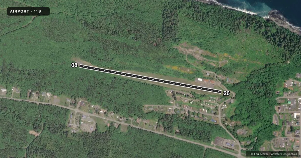
Airport sketch
Runways drawn to scale from FAA survey coordinates, rendered over satellite imagery. Not for navigation.
Approaches & charts
Services on the field
Fuel grades, oxygen, maintenance, ramp storage and lighting — as declared to the FAA by the airport operator.
Fuel & services
- Fuel
- Not available
- Oxygen (bottled)
- Not available
- Oxygen (bulk)
- Not available
- Airframe repair
- Not available
- Power plant repair
- Not available
Ramp & ground
- Transient storage
- Tie-down
- Landing fee
- No fee published
- Lighting schedule
- SS-SR
- Beacon schedule
- SS-SR
- Beacon
- White / Green (civil land)(WG)
- Wind indicator
- Lighted
- Segmented circle
- No
Fuel & FBOs
Cheapest 100LL and Jet A on the field and nearby. Always confirm with the FBO before taxi.
Airport notes
Surface conditions, obstructions, local procedures, lighting outages and other notes published with each FAA cycle.
General notes
- TURBULENCE ON E END APCH OVER WATER. DIFFICULT APCH WHEN WIND IS FROM N.
- HI RIDGE ALONG N SIDE OF RWY.
- DEER ON & INVOF ARPT SEP-MAR.
- BRUSH, BLDGS, FENCES IN PRIMARY SFC.
- TALL TREES IN TRANSITION AREAS BOTH SIDE OF RWY.
- FOR CD CTC SEATTLE ARTCC AT 253-351-3694.
- BATHROOM LOCK COMBINATION IS 2608.
Approach & departure obstructions
- 0839 FT TREES 125 FT L & R OF CNTRLN 0 FT FM THR.
- 26RWY 26, CLIFF, 47 FT R AND 71 FT L FM RWY END.
- 26NSTD 2-BOX VASI LEFT SIDE NGTS ONLY.
- 08RY 08 APCH SLOPE 50:1 FROM DSPLCD THLD.
Other notes
- ESTABLISHED PRIOR TO 15 MAY 1959.
- PILOTS BRING OWN ROPES.
- 08/26WDSPR ALLIGATOR AND BLOCK CRACKING.
VFR map & nearby airports
VFR sectional. Tap any ICAO chip to open that airport.
Key facts · 11S
Answer card- ICAO
- 11S
- Name
- SEKIU
- Location
- SEKIU, WASHINGTON
- Elevation
- 355 ft MSL
- Traffic pattern altitude
- 1,355 ft MSL (1,000 AGL)
- Control tower
- Non-towered (use CTAF)
- Total runways
- 1
- Longest runway
- 08/26 · 2,997 ft
- Published ILS approaches
- 0
- Published frequencies
- 1
- Magnetic variation
- 21°
- Current flight rules
- VFR
- Current wind
- 250° at 4 kt
- Favored runway now
- RWY 26
Sekiu Airport sits in Sekiu, Washington. Field elevation is 355 ft MSL. It has one runway, 08/26, which is 2,997 ft long and asphalt. There is no control tower. CTAF is 122.9.
No ILS approaches are published here. Pattern altitude is not published, so use the standard 1,000 ft AGL for light piston operations unless the current FAA Chart Supplement says otherwise. The runway headings are magnetic. Runway 08 is the eastbound end. Runway 26 is the westbound end.
There are no on-field FBOs listed. Plan on self-sufficiency. The published remarks matter here. The runway surface has widespread cracking. There is a high ridge along the north side of the runway. Runway 08 has trees close to the threshold. Runway 26 has a cliff near the departure end. Pilots also report turbulence on the east end approach over water. The approach can be difficult when the wind is from the north. Deer are reported on and near the airport from September through March. For clearance delivery, contact Seattle ARTCC. Bring your own ropes if you need them on the ground. First-time arrivals should review the current Chart Supplement before going in, especially for terrain, wind and runway condition.