METAR & TAF KEUG
Current METAR
Observed 11:54Z
KEUG 271154Z AUTO 15005KT 10SM CLR 10/09 A3010 RMK AO2 SLP192 T01000094 10156 20100 53001 $
- Wind
- 150° @ 5 kt
- Visibility
- 10 SM
- Temp / Dew
- 10°C / 9°C
- Altimeter
- 30.10 inHg
- Clouds
- CLR
- Density alt
- -360 ft
- Ceiling
- Unlimited
- Rules
- VFR
Airport info & contacts
Manager on record, flight service, ARTCC, attendance schedule and pattern altitude — published by the FAA and refreshed every 28 days.
Location
- From city
- 7 NM NW
- VFR sectional
- KLAMATH FALLS
- Pattern altitude
- 800 ft AGL · 1,174 ft MSL
- ARTCC
- ZSE · SEATTLE
- NOTAM facility
- EUG (NOTAM-D)
Airport manager
- Name
- CATHRYN STEPHENS
- Phone
- 541-682-5430
- Address
- 28855 LOCKHEED DRIVE, EUGENE OR 97402
Flight service · Hours
- FSS MMV
- MC MINNVILLE1-800-WX-BRIEF
- Attendance
- ALL
Frequencies
Tap any row to copy the frequency to your clipboard.
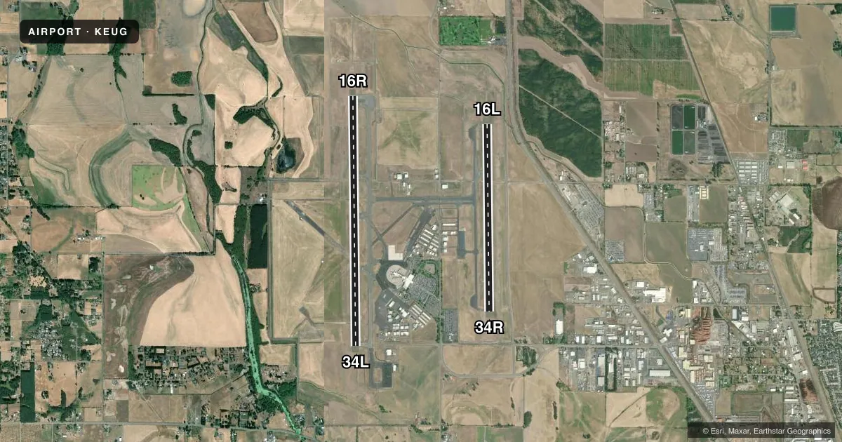
Runways & pattern
Full pagePattern entry · RWY 16R
LEFT TRAFFIC| Runway | Heading (°M) | Length | Surface | Traffic |
|---|---|---|---|---|
| 16R/34LFavored | 164° / 344° | 8,009 ft | ASPH | Standard L |
| 16L/34R | 164° / 344° | 6,000 ft | ASPH | Standard L |
Runway end performance
| End | TORA | TODA | ASDA | LDA | VGSI | Approach lights | Obstruction |
|---|---|---|---|---|---|---|---|
| 16R | 8,009' | 8,009' | 8,009' | 8,009' | PAPI 4-box left(3°) | ALSF2 | — |
| 34L | 8,009' | 8,009' | 8,009' | 8,009' | VASI 4-box left(3°) | ODALS | — |
| 16L | 6,000' | 6,000' | 6,000' | 6,000' | PAPI 4-box left(3°) | MALSR | — |
| 34R | 6,000' | 6,000' | 6,000' | 6,000' | PAPI 4-box left(3°) | — | — |
Declared distances in feet. TORA = takeoff run available, TODA = takeoff distance, ASDA = accelerate-stop, LDA = landing distance.
Airport sketch
Runways drawn to scale from FAA survey coordinates, rendered over satellite imagery. Not for navigation.
Approaches & charts
ILS · 2
Services on the field
Fuel grades, oxygen, maintenance, ramp storage and lighting — as declared to the FAA by the airport operator.
Fuel & services
- Fuel
- 100LLA
- Oxygen (bottled)
- HIGH/LOW
- Oxygen (bulk)
- HIGH/LOW
- Airframe repair
- Major
- Power plant repair
- Major
- Other services
- AFRT,AGRI,AMB,AVNCS,CARGO,CHTR,INSTR,RNTL,SALES
Ramp & ground
- Transient storage
- Tie-down
- Landing fee
- Yes
- Customs
- Not available
- Lighting schedule
- SEE RMK
- Beacon schedule
- SS-SR
- Beacon
- White / Green (civil land)(WG)
- Wind indicator
- Lighted
- Segmented circle
- Yes
Fuel & FBOs
Cheapest 100LL and Jet A on the field and nearby. Always confirm with the FBO before taxi.
Airport notes
Surface conditions, obstructions, local procedures, lighting outages and other notes published with each FAA cycle.
General notes
- WATERFOWL & BIRDS ON & INVOF ARPT.
- TWYS H & K UNAVBL TO 21000 LB SW & 40000 LB DW GWT.
- TRML APRON CLSD; PPR EXC SKED ACR.
- HEL ARR & DEP AVOID OTFC OF AIRLINE PAX TRML & RAMP E OF RWY 16R/34L.
- RWY 34L ACES BYD TWY A6 NA.
- FOR CD IF UNA TO CTC ON FSS FREQ, CTC SEATTLE ARTCC AT 253-351-3694.
Lighting notes
- WHEN ATCT CLSD ACTVT ALSF2 RWY 16R; MALSR RWY 16L; ODALS RWY 34L; REIL RWY 34R - CTAF. PAPI RWY 16R, 16L & 34R; VASI RWY 34L OPR CONSLY. WHEN ATCT CLSD HIRL RWY 16L/34R & 16R/34L PRESET MED INTST.
Runway surface & condition
- 16L/34RPCR VALUE: 688/F/D/X/T
- 16R/34LPCR VALUE: 2818/F/D/X/T
Other notes
- PPR FOR UNSKED ACR OPS GTR THAN 30 PAX SEATS - 541-682-5430. ARFF AVBL H24. ARFF INDEX D H24; PPR.
VFR map & nearby airports
VFR sectional. Tap any ICAO chip to open that airport.
Key facts · KEUG
Answer card- ICAO
- KEUG
- Name
- MAHLON SWEET FLD
- Location
- EUGENE, OREGON
- Elevation
- 373.7 ft MSL
- Traffic pattern altitude
- 1,173.7 ft MSL (800 AGL)
- Control tower
- Towered · 0600-2330
- Total runways
- 2
- Longest runway
- 16R/34L · 8,009 ft
- Published ILS approaches
- 2
- Published frequencies
- 16
- Magnetic variation
- 15°
- Current flight rules
- VFR
- Current wind
- 150° at 5 kt
- Favored runway now
- RWY 16R
KEUG is Mahlon Sweet Fld in Eugene, Oregon. The field elevation is 373.7 ft MSL. It has two asphalt runways. The longest is 16R/34L at 8,009 ft. The tower is open daily from 0600 to 2330. When the tower is closed, published lighting procedures apply for the runway ends. KEUG has ILS approaches on runway ends 16L and 16R. Pattern altitude is 800 ft AGL, which is 1,173.7 ft MSL.
Atlantic Aviation is on the field. It carries 100LL and Jet A. Call ahead at (541) 688-9291 for current services. The published remarks also note bird activity on and near the airport. That matters here. Plan for a normal scan on departure and arrival, especially at low altitude and on base to final.
First-time pilots should also pay attention to the airport layout. Runway 34L access beyond taxiway A6 is not authorized. Terminal apron access is restricted too. Prior permission is required except for scheduled aircraft. Helicopter crews should avoid overflying the airline passenger terminal and the ramp east of runway 16R/34L. If you need current clearance or operational details, use the current FAA Chart Supplement or call the airport operator directly.