METAR & TAF KRBG
Current METAR
Observed 05:53Z
KRBG 270553Z AUTO 03005KT 10SM CLR 18/12 A3009 RMK AO2 SLP188 T01830117 10289 20183 51021
- Wind
- 030° @ 5 kt
- Visibility
- 10 SM
- Temp / Dew
- 18°C / 12°C
- Altimeter
- 30.09 inHg
- Clouds
- CLR
- Density alt
- 811 ft
- Ceiling
- Unlimited
- Rules
- VFR
Airport info & contacts
Manager on record, flight service, ARTCC, attendance schedule and pattern altitude — published by the FAA and refreshed every 28 days.
Location
- From city
- 1 NM NW
- VFR sectional
- KLAMATH FALLS
- ARTCC
- ZSE · SEATTLE
- NOTAM facility
- RBG (NOTAM-D)
Airport manager
- Name
- NIKKI MESSENGER
- Phone
- 541-672-7701
- Address
- 900 SE DOUGLAS, ROSEBURG OR 97470
Flight service · Hours
- FSS MMV
- MC MINNVILLE1-800-WX-BRIEF
- Attendance
- 0800-1700
Frequencies
Tap any row to copy the frequency to your clipboard.
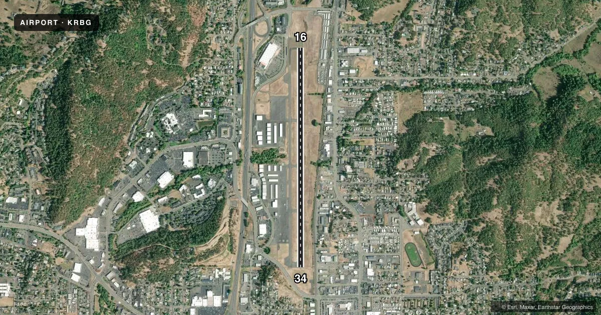
Runways & pattern
Full pagePattern entry · RWY 34
LEFT TRAFFICRunway end performance
| End | TORA | TODA | ASDA | LDA | VGSI | Approach lights | Obstruction |
|---|---|---|---|---|---|---|---|
| 16 | — | — | — | — | — | — | 26', hill, 380' from thr, 250' R of cntrln, slope 6 |
| 34 | — | — | — | — | PAPI 4-box right(4°) | — | 20', road, 220' from thr, 250' R of cntrln, slope 1 |
Declared distances in feet. TORA = takeoff run available, TODA = takeoff distance, ASDA = accelerate-stop, LDA = landing distance.
Airport sketch
Runways drawn to scale from FAA survey coordinates, rendered over satellite imagery. Not for navigation.
Approaches & charts
Services on the field
Fuel grades, oxygen, maintenance, ramp storage and lighting — as declared to the FAA by the airport operator.
Fuel & services
- Fuel
- 100LLA
- Oxygen (bottled)
- Not available
- Oxygen (bulk)
- High pressure
- Airframe repair
- Major
- Power plant repair
- Major
- Other services
- CHTR,INSTR,RNTL
Ramp & ground
- Transient storage
- Tie-down
- Landing fee
- No fee published
- Customs
- Not available
- Lighting schedule
- SEE RMK
- Beacon schedule
- SS-SR
- Beacon
- White / Green (civil land)(WG)
- Wind indicator
- Yes
- Segmented circle
- Yes
Fuel & FBOs
Cheapest 100LL and Jet A on the field and nearby. Always confirm with the FBO before taxi.
Airport notes
Surface conditions, obstructions, local procedures, lighting outages and other notes published with each FAA cycle.
General notes
- WATERFOWL ON & INVOF ARPT.
- +700 TO 1200 FT TRRN SRND ARPT WI 2 MI.
- FOR CD IF UNA TO CTC ON FSS FREQ, CTC SEATTLE ARTCC AT 253-351-3694.
Lighting notes
- ACTVT REIL RWY 16 & 34; MIRL RWY 16/34 - CTAF. RWY 34 PAPI OPR CONSLY.
Approach & departure obstructions
- 16150 FT BLAST PAD MARKED WITH YELLOW CHEVRONS.
- 1614:1 BASED ON DSPLCD THR.
- 3419:1 BASED ON DTHR.
VFR map & nearby airports
VFR sectional. Tap any ICAO chip to open that airport.
Key facts · KRBG
Answer card- ICAO
- KRBG
- Name
- ROSEBURG RGNL
- Location
- ROSEBURG, OREGON
- Elevation
- 533.4 ft MSL
- Traffic pattern altitude
- 1,533.4 ft MSL (1,000 AGL)
- Control tower
- Non-towered (use CTAF)
- Total runways
- 1
- Longest runway
- 16/34 · 5,003 ft
- Published ILS approaches
- 0
- Published frequencies
- 2
- Magnetic variation
- 14°
- Current flight rules
- VFR
- Current wind
- 030° at 5 kt
- Favored runway now
- RWY 34
Roseburg Rgnl is in Roseburg, Oregon. Field elevation is 533.4 ft MSL. The airport has one runway. Runway 16/34 is 5,003 ft of asphalt, so that is the longest runway by default. There is no control tower, so use CTAF 122.8 for traffic and UNICOM. No ILS approaches are published here.
Pattern altitude is not published. Use the standard 1,000 ft AGL pattern for light piston traffic unless the current Chart Supplement or local guidance says otherwise. The published remarks matter here. Runway 16 and 34 have runway end identifier lights. Medium intensity runway lights on 16/34 are CTAF controlled. Runway 34 PAPI operates continuously. Runway 16 has a 150-foot blast pad marked with yellow chevrons.
Western Oregon Flying Services is on the field. It carries 100LL, Jet A and Jet A Prist. The airport also sits in terrain that rises about 700 to 1,200 ft within 2 NM. Waterfowl are reported on and near the airport, so keep a sharp scan on approach and departure. Runway 16 has a displaced-threshold obstacle clearance slope of 14 to 1. Runway 34 is listed at 19 to 1. If you need clearance delivery and cannot reach Flight Service, the published contact is Seattle ARTCC.