METAR & TAF 6S6
6S6 does not publish a METAR.
Showing the nearest reporting station: KOTH (SOUTHWEST OREGON RGNL) · 33.9 NM away. Conditions at 6S6 may differ.
METAR · KOTH
Observed 12:54Z
KOTH 221254Z 16005KT 10SM OVC003 13/13 A2994
- Wind
- 160° @ 5 kt
- Visibility
- 10 SM
- Temp / Dew
- 13°C / 13°C
- Altimeter
- 29.94 inHg
- Clouds
- OVC
- Density alt
- 139 ft
- Ceiling
- 300 ft AGL
- Rules
- LIFR
Airport info & contacts
Manager on record, flight service, ARTCC, attendance schedule and pattern altitude — published by the FAA and refreshed every 28 days.
Location
- From city
- 1 NM SE
- VFR sectional
- KLAMATH FALLS
- ARTCC
- ZSE · SEATTLE
- NOTAM facility
- MMV (NOTAM-D)
Airport manager
- Name
- PORT OF COQUILLE RIVER
- Phone
- (541) 572-2737
- Address
- PO BOX 640, MYRTLE POINT OR 97458
Flight service · Hours
- FSS MMV
- MC MINNVILLE1-800-WX-BRIEF
- Attendance
- Unattended
Frequencies
Tap any row to copy the frequency to your clipboard.
Runways & pattern
Full pagePattern entry · RWY 13
LEFT TRAFFICRunway end performance
| End | TORA | TODA | ASDA | LDA | VGSI | Approach lights | Obstruction |
|---|---|---|---|---|---|---|---|
| 13 | — | — | — | — | — | — | 45', trees, 194' from thr, 0' R of cntrln, slope 4 |
| 31 | — | — | — | — | — | — | 12', trees, 45' from thr, 0' R of cntrln, slope 3 |
Declared distances in feet. TORA = takeoff run available, TODA = takeoff distance, ASDA = accelerate-stop, LDA = landing distance.
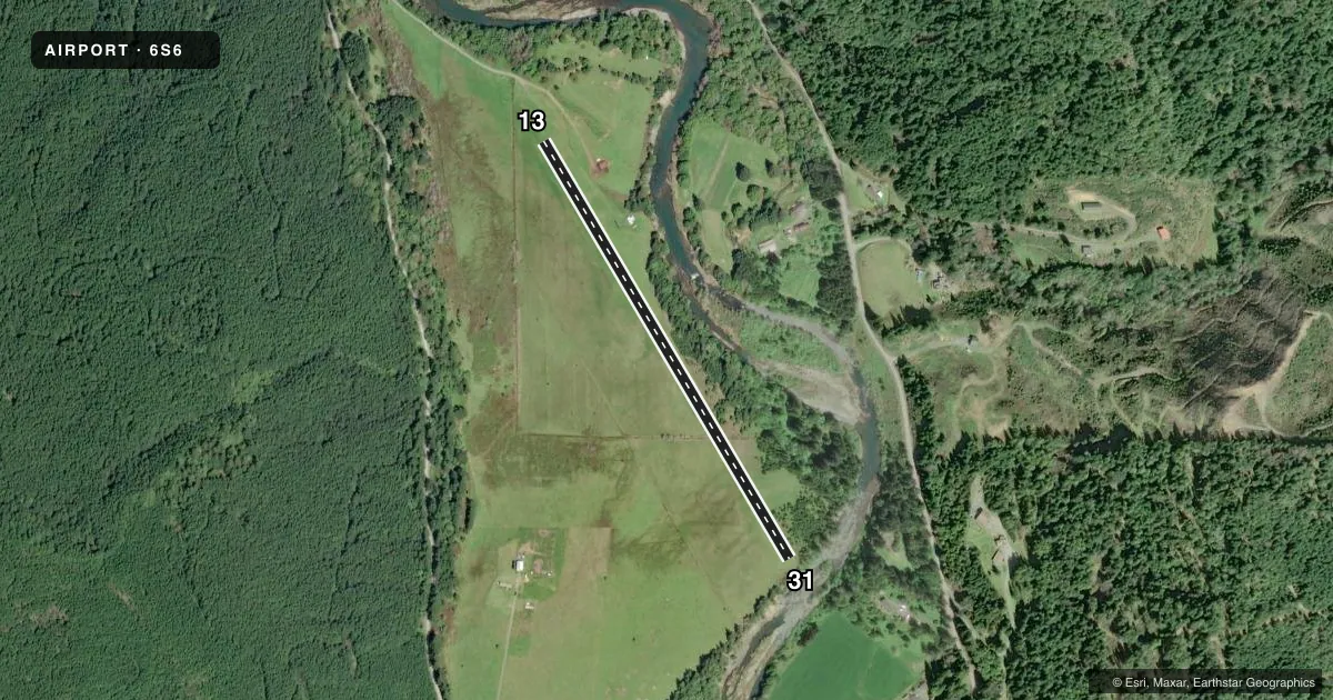
Airport sketch
Runways drawn to scale from FAA survey coordinates, rendered over satellite imagery. Not for navigation.
Approaches & charts
Services on the field
Fuel grades, oxygen, maintenance, ramp storage and lighting — as declared to the FAA by the airport operator.
Fuel & services
- Fuel
- Not available
- Oxygen (bottled)
- Not available
- Oxygen (bulk)
- Not available
- Airframe repair
- Not available
- Power plant repair
- Not available
Ramp & ground
- Transient storage
- Tie-down
- Landing fee
- No fee published
- Customs
- Not available
- Wind indicator
- Yes
- Segmented circle
- No
Fuel & FBOs
Cheapest 100LL and Jet A on the field and nearby. Always confirm with the FBO before taxi.
Airport notes
Surface conditions, obstructions, local procedures, lighting outages and other notes published with each FAA cycle.
General notes
- ARPT IN VALLEY SURROUNDED BY HIGH TERRAIN.
- LIVESTOCK AND WILDLIFE ON & INVOF OF ARPT.
- FOR CD CTC SEATTLE ARTCC AT 253-351-3694.
- RWY 31 HAS 25 FT TREES WI 35 FT OF CNTRLN ALG EDGE TO 1700 FT FM THR.
Approach & departure obstructions
- 13RUNWAY END NOT MARKED
- 31RWY 31 THLD MKD WITH WHITE TIRES.
VFR map & nearby airports
VFR sectional. Tap any ICAO chip to open that airport.
Key facts · 6S6
Answer card- ICAO
- 6S6
- Name
- POWERS
- Location
- POWERS, OREGON
- Elevation
- 326 ft MSL
- Traffic pattern altitude
- 1,326 ft MSL (1,000 AGL)
- Control tower
- Non-towered (use CTAF)
- Total runways
- 1
- Longest runway
- 13/31 · 2,500 ft
- Published ILS approaches
- 0
- Published frequencies
- 1
- Magnetic variation
- 18°
- Current flight rules
- LIFR
- Current wind
- 160° at 5 kt
- Favored runway now
- RWY 13
POWERS Airport (6S6) sits in Powers, Oregon at 326 ft MSL. It has one runway. Runway 13/31 is 2,500 ft of turf, which is the longest runway on the field. The airport is non-towered. CTAF is 122.9.
No ILS approaches are published here. Pattern altitude is not published, so use the current Chart Supplement before you go. The field sits in a valley surrounded by high terrain. That matters for arrival planning and climb performance. Livestock and wildlife are also on and near the airport. Keep a sharp scan on taxi, takeoff and final.
Runway 13 end is not marked. Runway 31 has white tires marking the threshold. There are also 25-foot trees within 35 feet of the runway centerline along the edge to 1,700 feet from the 31 threshold. That makes the 31 end worth a careful look on short final. For clearance delivery, contact Seattle ARTCC at 253-351-3694. No on-field FBOs are listed, so verify services with the airport operator or call ahead before arrival.