METAR & TAF S05
S05 does not publish a METAR.
Showing the nearest reporting station: KOTH (SOUTHWEST OREGON RGNL) · 21.1 NM away. Conditions at S05 may differ.
METAR · KOTH
Observed 12:54Z
KOTH 221254Z 16005KT 10SM OVC003 13/13 A2994
- Wind
- 160° @ 5 kt
- Visibility
- 10 SM
- Temp / Dew
- 13°C / 13°C
- Altimeter
- 29.94 inHg
- Clouds
- OVC
- Density alt
- -113 ft
- Ceiling
- 300 ft AGL
- Rules
- LIFR
Airport info & contacts
Manager on record, flight service, ARTCC, attendance schedule and pattern altitude — published by the FAA and refreshed every 28 days.
Location
- From city
- 2 NM SE
- VFR sectional
- KLAMATH FALLS
- ARTCC
- ZSE · SEATTLE
- NOTAM facility
- MMV (NOTAM-D)
Airport manager
- Name
- STATE AIRPORTS MGR
- Phone
- 503-378-4880
- Address
- 3040 25TH ST SE, SALEM OR 97302-1125
Flight service · Hours
- FSS MMV
- MC MINNVILLE1-800-WX-BRIEF
- Attendance
- 0700-1800
Frequencies
Tap any row to copy the frequency to your clipboard.
Runways & pattern
Full pagePattern entry · RWY 16
LEFT TRAFFICRunway end performance
| End | TORA | TODA | ASDA | LDA | VGSI | Approach lights | Obstruction |
|---|---|---|---|---|---|---|---|
| 16 | — | — | — | — | PAPI 4-box left(4°) | — | — |
| 34 | — | — | — | — | PAPI 4-box left(4°) | — | 97', trees, 1614' from thr, 0' R of cntrln, slope 14 |
Declared distances in feet. TORA = takeoff run available, TODA = takeoff distance, ASDA = accelerate-stop, LDA = landing distance.
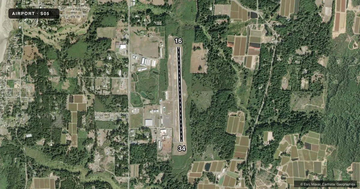
Airport sketch
Runways drawn to scale from FAA survey coordinates, rendered over satellite imagery. Not for navigation.
Approaches & charts
Services on the field
Fuel grades, oxygen, maintenance, ramp storage and lighting — as declared to the FAA by the airport operator.
Fuel & services
- Fuel
- 100LL
- Oxygen (bottled)
- Not available
- Oxygen (bulk)
- Not available
- Airframe repair
- Major
- Power plant repair
- Major
- Other services
- INSTR,RNTL,SALES
Ramp & ground
- Transient storage
- Tie-down
- Landing fee
- No fee published
- Customs
- Not available
- Lighting schedule
- SEE RMK
- Beacon schedule
- SS-SR
- Beacon
- White / Green (civil land)(WG)
- Wind indicator
- Lighted
- Segmented circle
- Yes
Fuel & FBOs
Cheapest 100LL and Jet A on the field and nearby. Always confirm with the FBO before taxi.
Airport notes
Surface conditions, obstructions, local procedures, lighting outages and other notes published with each FAA cycle.
General notes
- TWY MKD WITH BLUE REFLECTORS.
- DEER INVOF RY & ARPT.
- FOR CD CTC SEATTLE ARTCC AT 253-351-3694.
- SFC CONDS NOT RPRTD.
Lighting notes
- ACTVT MIRL RY 16/34; REIL RYS 16 & 34 AND PAPI RYS 16/34 - CTAF.
Approach & departure obstructions
- 34UNUSBL BYD 7 DEGS RIGHT OF CNTRLN
Other notes
- ESTABD PRIOR TO 1959.
VFR map & nearby airports
VFR sectional. Tap any ICAO chip to open that airport.
Key facts · S05
Answer card- ICAO
- S05
- Name
- BANDON STATE
- Location
- BANDON, OREGON
- Elevation
- 122.1 ft MSL
- Traffic pattern altitude
- 1,122.1 ft MSL (1,000 AGL)
- Control tower
- Non-towered (use CTAF)
- Total runways
- 1
- Longest runway
- 16/34 · 3,601 ft
- Published ILS approaches
- 0
- Published frequencies
- 2
- Magnetic variation
- 18°
- Current flight rules
- LIFR
- Current wind
- 160° at 5 kt
- Favored runway now
- RWY 16
Bandon State Airport sits in Bandon, Oregon on the south coast. Field elevation is 122.1 ft MSL. It has one runway. Runway 16/34 is 3,601 ft long with an asphalt surface. There is no control tower. CTAF and UNICOM are both 122.8.
No ILS approaches are published here. Pattern altitude is not published, so use the standard 1,000 ft AGL for light piston traffic unless the current Chart Supplement says otherwise. The field uses magnetic variation of 18°. Taxiways are marked with blue reflectors. Medium intensity runway lights are available on runway 16/34. REILs are on both ends. PAPI is also on both ends. Lighting is controlled on CTAF.
Bandon Aviation is on the field. It carries 100LL. Call (541) 347-2022 for current service details. The published remarks also note deer in the vicinity of the runway and airport. Surface conditions are not reported, so plan for a normal preflight and check the runway yourself on arrival. Runway 34 has a published note that the visual glide slope indicators are unusable beyond 7 degrees right of centerline. For clearance delivery, contact Seattle ARTCC at 253-351-3694. Pilots should also expect coastal weather changes and stay alert for wildlife on the movement area.