METAR & TAF 5S1
5S1 does not publish a METAR.
Showing the nearest reporting station: KRBG (ROSEBURG RGNL) · 2.6 NM away. Conditions at 5S1 may differ.
METAR · KRBG
Observed 11:53Z
KRBG 271153Z AUTO 00000KT 10SM CLR 13/11 A3010 RMK AO2 SLP191 T01280106 10183 20128 53004
- Wind
- 000° @ 0 kt
- Visibility
- 10 SM
- Temp / Dew
- 13°C / 11°C
- Altimeter
- 30.10 inHg
- Clouds
- CLR
- Density alt
- 68 ft
- Ceiling
- Unlimited
- Rules
- VFR
Airport info & contacts
Manager on record, flight service, ARTCC, attendance schedule and pattern altitude — published by the FAA and refreshed every 28 days.
Location
- From city
- 3 NM W
- VFR sectional
- KLAMATH FALLS
- ARTCC
- ZSE · SEATTLE
- NOTAM facility
- MMV (NOTAM-D)
Airport manager
- Name
- JOHN ABERCROMBIE
- Phone
- 541-673-7709
- Address
- 415 NW FELT, ROSEBURG OR 97470
Flight service · Hours
- FSS MMV
- MC MINNVILLE1-800-WX-BRIEF
- Attendance
- IREG
Frequencies
Tap any row to copy the frequency to your clipboard.
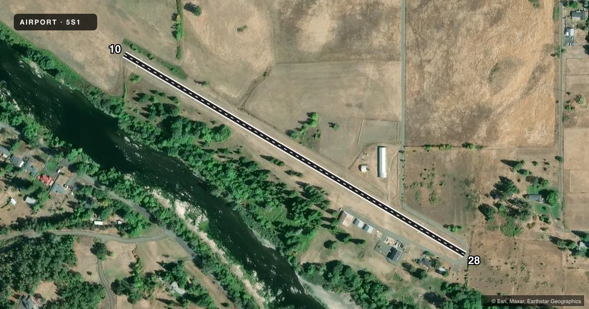
Runways & pattern
Full pagePattern entry · RWY 10
LEFT TRAFFICRunway end performance
| End | TORA | TODA | ASDA | LDA | VGSI | Approach lights | Obstruction |
|---|---|---|---|---|---|---|---|
| 10 | — | — | — | — | — | — | 285', tree, 2670' from thr, 0' R of cntrln, slope 9 |
| 28 | — | — | — | — | — | — | 12', brush, 10' from thr, 20' R of cntrln, slope 0 |
Declared distances in feet. TORA = takeoff run available, TODA = takeoff distance, ASDA = accelerate-stop, LDA = landing distance.
Airport sketch
Runways drawn to scale from FAA survey coordinates, rendered over satellite imagery. Not for navigation.
Approaches & charts
Services on the field
Fuel grades, oxygen, maintenance, ramp storage and lighting — as declared to the FAA by the airport operator.
Fuel & services
- Fuel
- Not available
- Oxygen (bottled)
- Not available
- Oxygen (bulk)
- Not available
- Airframe repair
- Not available
- Power plant repair
- Not available
Ramp & ground
- Transient storage
- Tie-down
- Landing fee
- No fee published
- Customs
- Not available
- Wind indicator
- Yes
Fuel & FBOs
Cheapest 100LL and Jet A on the field and nearby. Always confirm with the FBO before taxi.
Airport notes
Surface conditions, obstructions, local procedures, lighting outages and other notes published with each FAA cycle.
General notes
- BIRD HAZARD--MIGRATORY FLOCKS OF WATERFOWL ON & INVOF ARPT.
- DEER FREQUENTLY ON RY.
- SOFT EARTH OFF RY & TWY WHEN WET.
- FOR NOISE ABATEMENT; FLY TO RIVER BEFORE TURNING.
- RY 28 4' FENCE AT 30' CROSSING APCH.
- RY 10 +25 FT TREES AT 50 FT FROM CNTRLN BOTH SIDES.
- FOR CD CTC SEATTLE ARTCC AT 253-351-3694.
Approach & departure obstructions
- 103 FT FENCE MKR AT 20 FT ON CNTRLN.
- 10CTLG OBSTN EXCEEDS A 45 DEG SLP.
Other notes
- ESTABD PRIOR TO 1959.
- MONITOR ROSEBURG REGIONAL CTAF/UNICOM FOR CONFLICTING ACFT.
VFR map & nearby airports
VFR sectional. Tap any ICAO chip to open that airport.
Key facts · 5S1
Answer card- ICAO
- 5S1
- Name
- GEORGE FELT
- Location
- ROSEBURG, OREGON
- Elevation
- 428 ft MSL
- Traffic pattern altitude
- 1,428 ft MSL (1,000 AGL)
- Control tower
- Non-towered (use CTAF)
- Total runways
- 1
- Longest runway
- 10/28 · 2,300 ft
- Published ILS approaches
- 0
- Published frequencies
- 1
- Magnetic variation
- 18°
- Current flight rules
- VFR
- Current wind
- 000° at 0 kt
- Favored runway now
- –
George Felt Airport (5S1) sits in Roseburg, Oregon at 428 ft MSL. It has one runway. Runway 10/28 is 2,300 ft of turf. There is no control tower, so use CTAF 122.9 and monitor local traffic closely. No ILS approaches are published here.
Pattern altitude is not published. Use standard 1,000 ft AGL unless the current Chart Supplement says otherwise. That puts the light piston pattern at 1,428 ft MSL based on the field elevation. The airport has a few things a first-time pilot should plan for. Deer are frequently on the runway. Bird activity is also a factor because of migratory waterfowl nearby. Runway 10 has trees close in on both sides. Runway 28 has a fence crossing the approach path. Soft earth can be present off the runway and taxiway when wet. There is also a published obstruction that exceeds a 45 degree slope. For noise abatement, fly to the river before turning.