METAR & TAF 00S
00S does not publish a METAR.
Showing the nearest reporting station: KBDN (BEND MUNI) · 38.5 NM away. Conditions at 00S may differ.
METAR · KBDN
Observed 12:55Z
KBDN 271255Z AUTO 20003KT 10SM CLR 12/07 A3011 RMK AO2
- Wind
- 200° @ 3 kt
- Visibility
- 10 SM
- Temp / Dew
- 12°C / 7°C
- Altimeter
- 30.11 inHg
- Clouds
- CLR
- Density alt
- 1,413 ft
- Ceiling
- Unlimited
- Rules
- VFR
Airport info & contacts
Manager on record, flight service, ARTCC, attendance schedule and pattern altitude — published by the FAA and refreshed every 28 days.
Location
- From city
- 3 NM E
- VFR sectional
- KLAMATH FALLS
- ARTCC
- ZSE · SEATTLE
- NOTAM facility
- MMV (NOTAM-D)
Airport manager
- Name
- ANTHONY BEACH
- Phone
- 503-378-4880
- Address
- 3040 25TH ST, SE, SALEM OR 97302
Flight service · Hours
- FSS MMV
- MC MINNVILLE1-800-WX-BRIEF
- Attendance
- Unattended
Frequencies
Tap any row to copy the frequency to your clipboard.
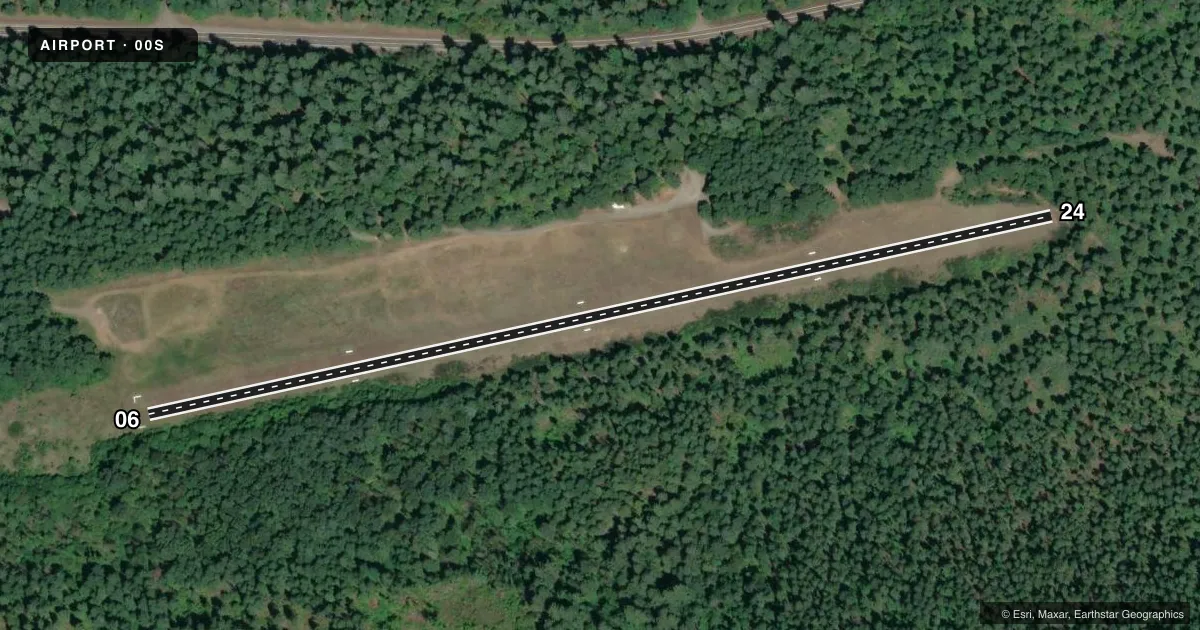
Runways & pattern
Full pagePattern entry · RWY 24
LEFT TRAFFICRunway end performance
| End | TORA | TODA | ASDA | LDA | VGSI | Approach lights | Obstruction |
|---|---|---|---|---|---|---|---|
| 06 | — | — | — | — | — | — | 125', trees, 1400' from thr, 120' R of cntrln, slope 11 |
| 24 | — | — | — | — | — | — | 144', trees, 60' from thr, 0' R of cntrln, slope 0 |
Declared distances in feet. TORA = takeoff run available, TODA = takeoff distance, ASDA = accelerate-stop, LDA = landing distance.
Airport sketch
Runways drawn to scale from FAA survey coordinates, rendered over satellite imagery. Not for navigation.
Approaches & charts
Services on the field
Fuel grades, oxygen, maintenance, ramp storage and lighting — as declared to the FAA by the airport operator.
Fuel & services
- Fuel
- Not available
- Oxygen (bottled)
- Not available
- Oxygen (bulk)
- Not available
- Airframe repair
- Not available
- Power plant repair
- Not available
Ramp & ground
- Transient storage
- Tie-down
- Landing fee
- No fee published
- Customs
- Not available
- Wind indicator
- Yes
- Segmented circle
- Yes
Fuel & FBOs
Cheapest 100LL and Jet A on the field and nearby. Always confirm with the FBO before taxi.
Airport notes
Surface conditions, obstructions, local procedures, lighting outages and other notes published with each FAA cycle.
General notes
- OWNER ADVISES CTC WITH OR DEPT OF AVIATION (503-378-4880) PRIOR TO USE.
- WILDLIFE ON AND INVOF ARPT YEAR ROUND.
- LAND EAST - TAKEOFF WEST.
- RY 06/24 SLOPES UP TO THE EAST.
- +500 FT RIDGELINE PARALLEL TO RY 1000 FT SOUTH.
- ARPT CLOSED NOV 1- MAY 1.
- EXPECT SIGNIFICANT TURBULENCE AND DOWNDRAFTS NEAR RY.
- FOR CD CTC SEATTLE ARTCC AT 253-351-3694.
- SFC CONDS NOT RPRTD.
Approach & departure obstructions
- 06RY 06 THLD MARKED WITH WHITE MATS.
Other notes
- ESTABD PRIOR TO 1959.
- 06/24RY 06/24 ROUGH ON EAST HALF.
VFR map & nearby airports
VFR sectional. Tap any ICAO chip to open that airport.
Key facts · 00S
Answer card- ICAO
- 00S
- Name
- MC KENZIE BRIDGE STATE
- Location
- MC KENZIE BRIDGE, OREGON
- Elevation
- 1,620 ft MSL
- Traffic pattern altitude
- 2,620 ft MSL (1,000 AGL)
- Control tower
- Non-towered (use CTAF)
- Total runways
- 1
- Longest runway
- 06/24 · 2,600 ft
- Published ILS approaches
- 0
- Published frequencies
- 1
- Magnetic variation
- 19°
- Current flight rules
- VFR
- Current wind
- 200° at 3 kt
- Favored runway now
- RWY 24
Mc Kenzie Bridge State sits in Mc Kenzie Bridge, Oregon. Field elevation is 1,620 ft MSL. The airport has one runway. Runway 06/24 is 2,600 ft of turf. No tower is published. CTAF is 122.9. No ILS approaches are published.
Pattern altitude is not published. Use 1,000 ft AGL for light piston operations unless the current FAA Chart Supplement says otherwise. The field is closed November 1 through May 1, so check status before you plan a trip. Published remarks also call out wildlife on and near the airport year round. Surface conditions are not reported. The runway slopes up to the east. The east half is rough. There is a ridgeline more than 500 ft AGL about 1,000 ft south of the runway. Expect turbulence and downdrafts near the field. The runway 06 threshold is marked with white mats.
There are no on-field FBOs listed. Contact the airport operator or the FBO directly by phone before arrival if you need current services. The owner also advises calling the Oregon Department of Aviation before use. For clearance delivery, Seattle ARTCC is listed in the remarks. This is a mountain field with limited runway length and turf surface. Plan conservatively and review the current Chart Supplement before you go.