METAR & TAF KBDN
Current METAR
Observed 11:15Z
KBDN 271115Z AUTO 00000KT 10SM CLR 12/06 A3010 RMK AO2
- Wind
- 000° @ 0 kt
- Visibility
- 10 SM
- Temp / Dew
- 12°C / 6°C
- Altimeter
- 30.10 inHg
- Clouds
- CLR
- Density alt
- 3,706 ft
- Ceiling
- Unlimited
- Rules
- VFR
Airport info & contacts
Manager on record, flight service, ARTCC, attendance schedule and pattern altitude — published by the FAA and refreshed every 28 days.
Location
- From city
- 5 NM NE
- VFR sectional
- KLAMATH FALLS
- ARTCC
- ZSE · SEATTLE
- NOTAM facility
- MMV (NOTAM-D)
Airport manager
- Name
- TRACY WILLIAMS
- Phone
- 541-647-0828
- Address
- BOX 431, BEND OR 97709
Flight service · Hours
- FSS MMV
- MC MINNVILLE1-800-WX-BRIEF
- Attendance
- SAT-SUN · 0800-1700
- MON-FRI · 0730-1800
Frequencies
Tap any row to copy the frequency to your clipboard.
Runways & pattern
Full pagePattern entry · RWY 17
RIGHT TRAFFICRunway end performance
| End | TORA | TODA | ASDA | LDA | VGSI | Approach lights | Obstruction |
|---|---|---|---|---|---|---|---|
| 17 | — | — | — | — | PAPI 4-box left(3°) | — | 18', trees, 542' from thr, 100' R of cntrln, slope 19 |
| 35 | — | — | — | — | PAPI 4-box left(3°) | — | 52', tree, 1496' from thr, 250' R of cntrln, slope 25 |
Declared distances in feet. TORA = takeoff run available, TODA = takeoff distance, ASDA = accelerate-stop, LDA = landing distance.
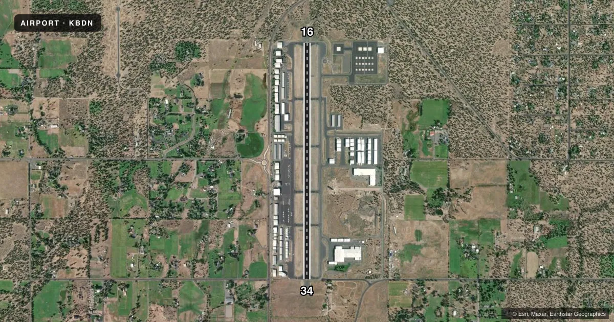
Airport sketch
Runways drawn to scale from FAA survey coordinates, rendered over satellite imagery. Not for navigation.
Approaches & charts
Services on the field
Fuel grades, oxygen, maintenance, ramp storage and lighting — as declared to the FAA by the airport operator.
Fuel & services
- Fuel
- 100LLA
- Oxygen (bottled)
- HIGH/LOW
- Oxygen (bulk)
- High pressure
- Airframe repair
- Major
- Power plant repair
- Major
- Other services
- AVNCS,CHTR,GLD,INSTR,RNTL,SALES,TOW
Ramp & ground
- Transient storage
- Tie-down
- Hangar
- Landing fee
- No fee published
- Customs
- Not available
- Lighting schedule
- SEE RMK
- Beacon schedule
- SS-SR
- Beacon
- White / Green (civil land)(WG)
- Wind indicator
- Lighted
- Segmented circle
- Yes
Fuel & FBOs
Cheapest 100LL and Jet A on the field and nearby. Always confirm with the FBO before taxi.
Airport notes
Surface conditions, obstructions, local procedures, lighting outages and other notes published with each FAA cycle.
General notes
- BOTH TWYS PARALLEL TO RY 17/35 MKD BY REFLECTORS.
- CALM WIND RWY 17.
- NOISE ABATEMENT PROCEDURES IN EFFECT, CALL FBO AT (541) 388-0019
- BE AWARE, INTENSE HELICOPTER TRAINING CONTINUALLY IN PROGRESS.
- EXTENSIVE GEESE ACTIVITY REPORTED ON AND NEAR ARPT YEAR AROUND. DEER AND OTHER WILDLIFE MAY BE PRESENT.
- APRON AREAS MAY BE HEAVILY CONGESTED AT TIMES WITH SVC VEHICLES, PEDESTRIAN AND AUTOMOBILE TFC.
- TAXILANES AND APRON ARE NSTD. ACFT MAY REQUIRE WING WALKERS, PARKING GUIDANCE AND/OR TUGGING AT PILOT DISCRETION TO INSURE ACFT CLEARANCE FROM OBSTACLES.
- TO AVOID PROPERTY DAMAGE EXERCISE JUDGEMENT AND COURTESY DURING RUN-UP IN VICINITY OF HANGARS.
- RP FIXED WING TO RMN WEST OF RWY USING RP RWY 17 AND LP RWY 35. ROTOR WING TO RMN EAST OF RWY AND USE RP 35 AND LP 17. FIXED WING ACFT-NO TURNS BFR END OF RWY.
- FOR CD CTC SEATTLE ARTCC AT 253-351-3694.
Lighting notes
- ACTVT REIL RWY 17 & 35; PAPI RWY 17 & 35; MIRL RWY 17/35 - CTAF.
Other notes
- EXISTED PRIOR TO 1959.
- GLIDER OPR ON & INVOF ARPT.
- SEGMENTED CRC LCTD AT NE END OF ARPT.
VFR map & nearby airports
VFR sectional. Tap any ICAO chip to open that airport.
Key facts · KBDN
Answer card- ICAO
- KBDN
- Name
- BEND MUNI
- Location
- BEND, OREGON
- Elevation
- 3,459.4 ft MSL
- Traffic pattern altitude
- 4,459.4 ft MSL (1,000 AGL)
- Control tower
- Non-towered (use CTAF)
- Total runways
- 1
- Longest runway
- 17/35 · 5,201 ft
- Published ILS approaches
- 0
- Published frequencies
- 2
- Magnetic variation
- 14°
- Current flight rules
- VFR
- Current wind
- 000° at 0 kt
- Favored runway now
- –
Bend Muni sits in Bend, Oregon. The field elevation is 3,459.4 ft MSL. It has one runway, 16/34, which is 5,201 ft long. There is no control tower. CTAF and UNICOM are both 123.0. No ILS approaches are published.
Pattern altitude is not published. Use the standard 1,000 ft AGL pattern for light piston aircraft unless the current Chart Supplement says otherwise. Skyservice is on the field. It carries AVGAS 100LL, JET A and JET A PRIST. Call them at (541) 383-8825 for current service details.
This is a high-elevation airport. Expect density altitude to matter, especially on warm days. The published remarks also call out nonstandard taxilanes and apron areas. Wing walkers, parking guidance, or tugging may be needed at pilot discretion. Traffic is mixed. Fixed wing aircraft use right traffic for runway 16. They use left traffic for runway 34. Rotor wing traffic stays east of the runway. The airport also sees glider activity, heavy helicopter training, geese and other wildlife. Runway 16/34 has REILs, PAPI and medium intensity runway lights activated on CTAF. The calm wind runway is 16.