METAR & TAF S33
Current METAR
Observed 12:15Z
KS33 271215Z AUTO 14003KT 10SM CLR 09/05 A3011 RMK AO2
- Wind
- 140° @ 3 kt
- Visibility
- 10 SM
- Temp / Dew
- 9°C / 5°C
- Altimeter
- 30.11 inHg
- Clouds
- CLR
- Density alt
- 2,067 ft
- Ceiling
- Unlimited
- Rules
- VFR
Airport info & contacts
Manager on record, flight service, ARTCC, attendance schedule and pattern altitude — published by the FAA and refreshed every 28 days.
Location
- From city
- 3 NM NW
- VFR sectional
- SEATTLE
- ARTCC
- ZSE · SEATTLE
- NOTAM facility
- MMV (NOTAM-D)
Airport manager
- Name
- LORRAINE MARTINELLI
- Phone
- 541-777-4935
- Address
- 2028 NW BERG DR, MADRAS OR 97741
Flight service · Hours
- FSS MMV
- MC MINNVILLE1-800-WX-BRIEF
- Attendance
- MON-FRI · 0800-1700
- SAT-SUN · 0900-1400
Frequencies
Tap any row to copy the frequency to your clipboard.
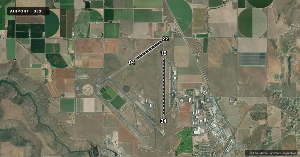
Runways & pattern
Full pagePattern entry · RWY 16
LEFT TRAFFIC| Runway | Heading (°M) | Length | Surface | Traffic |
|---|---|---|---|---|
| 16/34Favored | 164° / 344° | 5,091 ft | ASPH | Standard L |
| 04/22 | 39° / 219° | 2,701 ft | ASPH | Standard L |
Runway end performance
| End | TORA | TODA | ASDA | LDA | VGSI | Approach lights | Obstruction |
|---|---|---|---|---|---|---|---|
| 34 | — | — | — | — | VASI 4-box left(3°) | — | — |
| 22 | — | — | — | — | — | — | 15', road, 200' from thr, 240' R of cntrln, slope 0 |
Declared distances in feet. TORA = takeoff run available, TODA = takeoff distance, ASDA = accelerate-stop, LDA = landing distance.
Airport sketch
Runways drawn to scale from FAA survey coordinates, rendered over satellite imagery. Not for navigation.
Approaches & charts
Services on the field
Fuel grades, oxygen, maintenance, ramp storage and lighting — as declared to the FAA by the airport operator.
Fuel & services
- Fuel
- 100LLA
- Oxygen (bottled)
- HIGH/LOW
- Oxygen (bulk)
- Not available
- Airframe repair
- Major
- Power plant repair
- Major
- Other services
- AGRI,CHTR,INSTR,PAJA,RNTL
Ramp & ground
- Transient storage
- Tie-down
- Hangar
- Landing fee
- No fee published
- Customs
- Not available
- Lighting schedule
- SEE RMK
- Beacon schedule
- SS-SR
- Beacon
- White / Green (civil land)(WG)
- Wind indicator
- Lighted
- Segmented circle
- No
Fuel & FBOs
Cheapest 100LL and Jet A on the field and nearby. Always confirm with the FBO before taxi.
Airport notes
Surface conditions, obstructions, local procedures, lighting outages and other notes published with each FAA cycle.
General notes
- DEER, COYOTE AND COUGAR ON & INVOF ARPT.
- FOR CD CTC SEATTLE ARTCC AT 253-351-3694.
- COLD TEMPERATURE AIRPORT. ALTITUDE CORRECTION REQUIRED AT OR BELOW -20C.
Lighting notes
- ACTVT REIL RWY 34; VASI RWY 34; MRIL RWY 16/34 - CTAF
Approach & departure obstructions
- 22+5 FT FENCE 190 FT FM RY END 228 FT R.
- H1TLOF DIMENSIONS 100 X 100. FATO DIMENSIONS 162 X 162. SAFETY AREA DIMENSIONS 24 X 24. PRIMARY INGRESS/EGRESS; 164/344 DEGS.
- 04RY 04/22 MKD WITH WHITE REFLECTORS.
Other notes
- ESTABD PRIOR TO 1959.
VFR map & nearby airports
VFR sectional. Tap any ICAO chip to open that airport.
Key facts · S33
Answer card- ICAO
- S33
- Name
- MADRAS MUNI
- Location
- MADRAS, OREGON
- Elevation
- 2,437.6 ft MSL
- Traffic pattern altitude
- 3,437.6 ft MSL (1,000 AGL)
- Control tower
- Non-towered (use CTAF)
- Total runways
- 2
- Longest runway
- 16/34 · 5,091 ft
- Published ILS approaches
- 0
- Published frequencies
- 2
- Magnetic variation
- 16°
- Current flight rules
- VFR
- Current wind
- 140° at 3 kt
- Favored runway now
- RWY 16
Madras Muni sits in Madras, Oregon. The field elevation is 2,437.6 ft MSL. It has two asphalt runways. The longest is 5,091 ft on runway 16/34. There is no control tower. CTAF and UNICOM are both 122.8. No ILS approaches are published here.
Pattern altitude is not published, so use the standard 1,000 ft AGL for light piston traffic unless the current Chart Supplement says otherwise. The on-field FBO is Madras Municipal Airport. It carries 100LL, Jet A and Jet A Prist. Call (541) 777-4935 for current service details before you launch.
This is a cold temperature airport. Altitude correction is required at or below minus 20 degrees Celsius. That matters here because the field already sits above 2,400 ft MSL. Runway 34 has REILs and a VASI. Runways 16 and 34 have medium intensity runway lights on CTAF. Runway 04/22 is marked with white reflectors. Watch the published fence near the runway 22 end. Deer, coyote and cougar are reported in the area. If you need clearance delivery, contact Seattle ARTCC at 253-351-3694. Check the current Chart Supplement for any published noise or curfew restrictions before flying into the field.