METAR & TAF 6K5
6K5 does not publish a METAR.
Showing the nearest reporting station: KRDM (ROBERTS FLD/REDMOND MUNI) · 17.0 NM away. Conditions at 6K5 may differ.
METAR · KRDM
Observed 05:56Z
KRDM 270556Z AUTO 31005KT 10SM CLR 19/06 A3008 RMK AO2 SLP163 T01940056 10300 20183 51016
- Wind
- 310° @ 5 kt
- Visibility
- 10 SM
- Temp / Dew
- 19°C / 6°C
- Altimeter
- 30.08 inHg
- Clouds
- CLR
- Density alt
- 4,210 ft
- Ceiling
- Unlimited
- Rules
- VFR
Airport info & contacts
Manager on record, flight service, ARTCC, attendance schedule and pattern altitude — published by the FAA and refreshed every 28 days.
Location
- From city
- 1 NM N
- VFR sectional
- KLAMATH FALLS
- ARTCC
- ZSE · SEATTLE
- NOTAM facility
- MMV (NOTAM-D)
Airport manager
- Name
- DAVID CAMPBELL
- Phone
- (541) 719-0602
- Address
- 15820 BARCLAY DR, SISTERS OR 97759
Flight service · Hours
- FSS MMV
- MC MINNVILLE1-800-WX-BRIEF
- Attendance
- Unattended
Frequencies
Tap any row to copy the frequency to your clipboard.
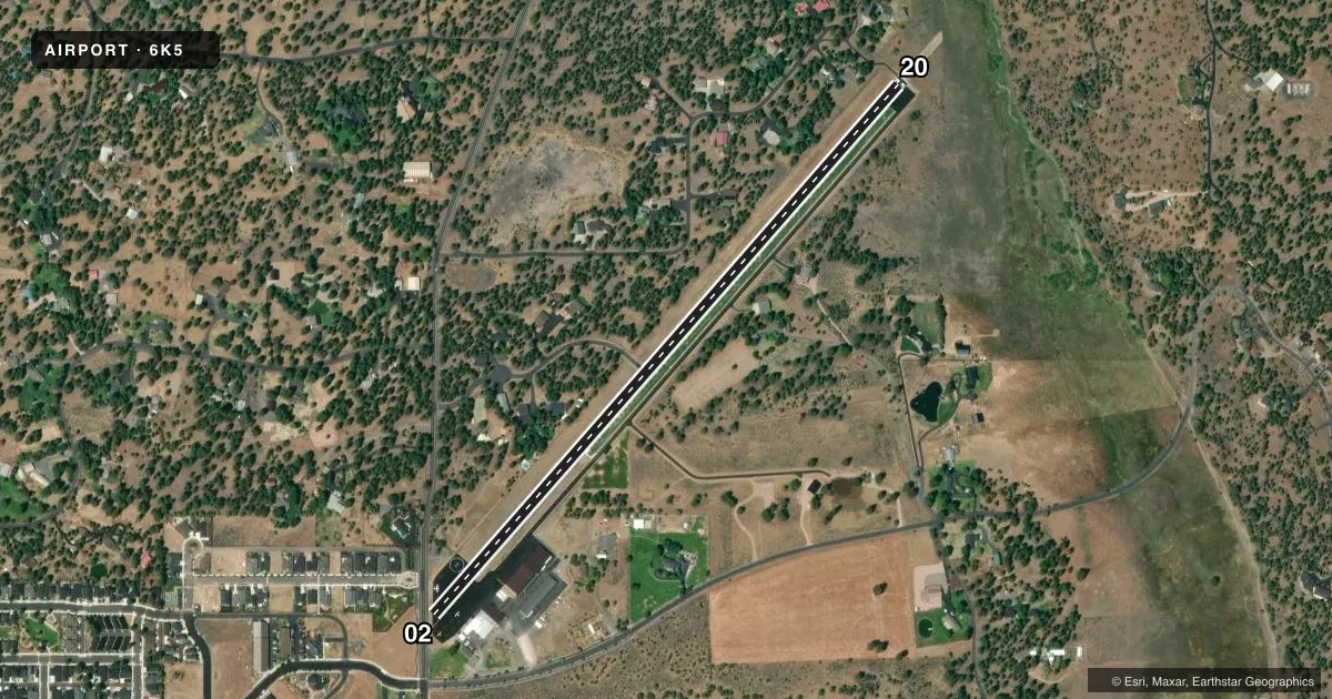
Runways & pattern
Full pagePattern entry · RWY 20
LEFT TRAFFICRunway end performance
| End | TORA | TODA | ASDA | LDA | VGSI | Approach lights | Obstruction |
|---|---|---|---|---|---|---|---|
| 02 | — | — | — | — | — | — | 16', tree, 201' from thr, 125' R of cntrln, slope 0 |
| 20 | — | — | — | — | — | — | 85', trees, 560' from thr, 100' R of cntrln, slope 4 |
Declared distances in feet. TORA = takeoff run available, TODA = takeoff distance, ASDA = accelerate-stop, LDA = landing distance.
Airport sketch
Runways drawn to scale from FAA survey coordinates, rendered over satellite imagery. Not for navigation.
Approaches & charts
Services on the field
Fuel grades, oxygen, maintenance, ramp storage and lighting — as declared to the FAA by the airport operator.
Fuel & services
- Fuel
- 100LL
- Oxygen (bottled)
- Not available
- Oxygen (bulk)
- Not available
- Airframe repair
- Not available
- Power plant repair
- Not available
Ramp & ground
- Transient storage
- Tie-down
- Landing fee
- No fee published
- Customs
- Not available
- Wind indicator
- Yes
- Segmented circle
- No
Fuel & FBOs
Cheapest 100LL and Jet A on the field and nearby. Always confirm with the FBO before taxi.
Airport notes
Surface conditions, obstructions, local procedures, lighting outages and other notes published with each FAA cycle.
General notes
- RISING TERRAIN OFF DEP END OF RY 02. CHECK DENSITY ALT/ACFT PERFORMANCE PRIOR TO TKOF. AVOID OVERFLIGHTS OF HOMES TO NE.
- DEER ON & INVOF ARPT.
- FOR CD CTC SEATTLE ARTCC AT 253-351-3694.
Approach & departure obstructions
- 02RWY 02 +15 FT ROAD 200' FROM THRSHLD; 4' FENCE AT 1' FROM RWY END AND 100' L OF CNTRLN; 16' ROAD AT 1' FROM RWY END AND 125' L OF CNTRLN.
- 205' FENCE AT 201' FROM RUNWAY END AND 100'L OF CENTERLINE
- 02RWY HAS W & YELLOW SIDESTRIPES & MARKINGS.
- 02SLP IS 12:1 TO DTHR.
Other notes
- ESTABD PRIOR TO 1959.
VFR map & nearby airports
VFR sectional. Tap any ICAO chip to open that airport.
Key facts · 6K5
Answer card- ICAO
- 6K5
- Name
- SISTERS EAGLE AIR
- Location
- SISTERS, OREGON
- Elevation
- 3,168 ft MSL
- Traffic pattern altitude
- 4,168 ft MSL (1,000 AGL)
- Control tower
- Non-towered (use CTAF)
- Total runways
- 1
- Longest runway
- 02/20 · 3,560 ft
- Published ILS approaches
- 0
- Published frequencies
- 1
- Magnetic variation
- 19°
- Current flight rules
- VFR
- Current wind
- 310° at 5 kt
- Favored runway now
- RWY 20
Sisters Eagle Air sits in Sisters, Oregon at 3,168 ft MSL. It has one runway, 02/20, which is 3,560 ft long and asphalt. The field is non-towered. CTAF is 122.9. No ILS approaches are published here. Pattern altitude is not published, so use the standard 1,000 ft AGL for light piston traffic unless the current FAA Chart Supplement says otherwise.
The on-field FBO is Sisters Eagle Airport. It carries 100LL and Jet A. Call (541) 719-0602 for current services before you go. Published remarks call out rising terrain off the departure end of runway 02. They also note deer on and near the airport. That matters here. Performance planning is important because the field is already at 3,168 ft MSL. Density altitude can climb fast in Central Oregon. The remarks also say to avoid overflights of homes to the northeast. Runway 02 has marked sidestrokes, which can help with runway recognition on arrival.
There is no tower. For clearance delivery, contact Seattle ARTCC at 253-351-3694. Check the current FAA Chart Supplement for any noise or curfew restrictions before flying into the field. If you are planning a first visit, brief the terrain, the short field length and the obstacle picture before takeoff.