METAR & TAF S39
Current METAR
Observed 10:55Z
KS39 271055Z AUTO 00000KT 10SM OVC030 11/02 A3011 RMK AO2
- Wind
- 000° @ 0 kt
- Visibility
- 10 SM
- Temp / Dew
- 11°C / 2°C
- Altimeter
- 30.11 inHg
- Clouds
- OVC
- Density alt
- 3,315 ft
- Ceiling
- 3,000 ft AGL
- Rules
- MVFR
Airport info & contacts
Manager on record, flight service, ARTCC, attendance schedule and pattern altitude — published by the FAA and refreshed every 28 days.
Location
- From city
- 3 NM SW
- VFR sectional
- KLAMATH FALLS
- ARTCC
- ZSE · SEATTLE
- NOTAM facility
- MMV (NOTAM-D)
Airport manager
- Name
- KELLY COFFELT
- Phone
- 541-416-0805
- Address
- 4585 SW AIRPORT ROAD, PRINEVILLE OR 97754
Flight service · Hours
- FSS MMV
- MC MINNVILLE1-800-WX-BRIEF
- Attendance
- SAT-SUN · 0900-1400
- MON-FRI · 0800-16:30
Frequencies
Tap any row to copy the frequency to your clipboard.
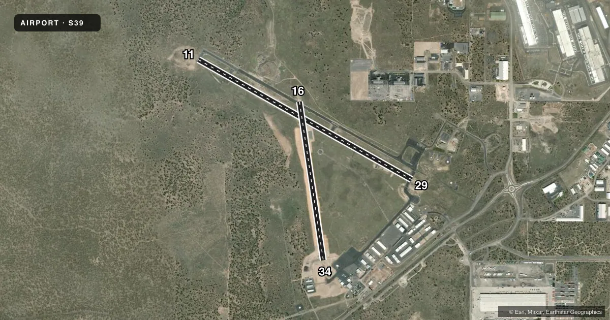
Runways & pattern
Full pagePattern entry · RWY 11
LEFT TRAFFIC| Runway | Heading (°M) | Length | Surface | Traffic |
|---|---|---|---|---|
| 11/29 | 105° / 285° | 5,405 ft | ASPH | Standard L |
| 16/34 | 157° / 337° | 3,536 ft | ASPH | Standard L |
Runway end performance
| End | TORA | TODA | ASDA | LDA | VGSI | Approach lights | Obstruction |
|---|---|---|---|---|---|---|---|
| 11 | — | — | — | — | — | — | 25', trees, 562' from thr, 48' R of cntrln, slope 14 |
| 29 | — | — | — | — | PAPI 4-box left(3°) | — | — |
Declared distances in feet. TORA = takeoff run available, TODA = takeoff distance, ASDA = accelerate-stop, LDA = landing distance.
Airport sketch
Runways drawn to scale from FAA survey coordinates, rendered over satellite imagery. Not for navigation.
Approaches & charts
Services on the field
Fuel grades, oxygen, maintenance, ramp storage and lighting — as declared to the FAA by the airport operator.
Fuel & services
- Fuel
- 100LLA
- Oxygen (bottled)
- Not available
- Oxygen (bulk)
- Not available
- Airframe repair
- Major
- Power plant repair
- Major
- Other services
- AGRI,INSTR
Ramp & ground
- Transient storage
- Tie-down
- Landing fee
- No fee published
- Customs
- Not available
- Lighting schedule
- SEE RMK
- Beacon schedule
- SS-SR
- Beacon
- White / Green (civil land)(WG)
- Wind indicator
- Lighted
- Segmented circle
- Yes
Fuel & FBOs
Cheapest 100LL and Jet A on the field and nearby. Always confirm with the FBO before taxi.
Airport notes
Surface conditions, obstructions, local procedures, lighting outages and other notes published with each FAA cycle.
General notes
- DEER ON & INVOF ARPT.
- FOR CD CTC SEATTLE ARTCC AT 253-351-3694.
- CALM WIND RWY 29
Lighting notes
- ACTVT MIRL RWY 11/29; PAPI RWY 29 & LIRL RWY 16/34 - CTAF.
Fuel notes
- 100LL24 HR CARD LOCK SELF-SVC FUEL AVBL.
Runway surface & condition
- 16/34LIMITED BY ARPT OPERATOR TO 5000 LBS MAX WEIGHT.
Other notes
- ESTABD PRIOR TO 1959.
- 16/34NMRS AREAS OF UNSEALED LONGL AND TRANSVERSE CRACKING THRUT FULL LEN.
VFR map & nearby airports
VFR sectional. Tap any ICAO chip to open that airport.
Key facts · S39
Answer card- ICAO
- S39
- Name
- PRINEVILLE
- Location
- PRINEVILLE, OREGON
- Elevation
- 3,250.7 ft MSL
- Traffic pattern altitude
- 4,250.7 ft MSL (1,000 AGL)
- Control tower
- Non-towered (use CTAF)
- Total runways
- 2
- Longest runway
- 11/29 · 5,405 ft
- Published ILS approaches
- 0
- Published frequencies
- 2
- Magnetic variation
- 14°
- Current flight rules
- MVFR
- Current wind
- 000° at 0 kt
- Favored runway now
- –
Prineville Airport sits in Prineville, Oregon at 3,251 ft MSL. It has two asphalt runways. The longest is 11/29 at 5,405 ft. There is no control tower, so plan on CTAF and UNICOM 122.7 for local traffic. No ILS approaches are published here.
Pattern altitude is not published. Use 1,000 ft AGL as the standard light-piston pattern reference unless the current Chart Supplement says otherwise. That puts the pattern at about 4,251 ft MSL. Hood Aero is on the field. It carries 100LL, JET A and JET A Prist. Twenty-four hour card-lock self-serve fuel is available.
A few published remarks matter here. Runway 11/29 has medium intensity lights. Runway 29 also has PAPI. Runway 16/34 has low intensity lights that are activated by CTAF. The airport also notes deer in and near the movement area. Runway 16/34 is limited to 5,000 lb max weight by the airport operator. It also has widespread cracking along its length. For clearance delivery, contact Seattle ARTCC at 253-351-3694. The field is high enough that density altitude can matter on warm days. Watch your takeoff roll and climb performance.