METAR & TAF 5S2
5S2 does not publish a METAR.
Showing the nearest reporting station: KBDN (BEND MUNI) · 46.8 NM away. Conditions at 5S2 may differ.
METAR · KBDN
Observed 13:35Z
KBDN 271335Z AUTO 00000KT 10SM CLR 13/08 A3011 RMK AO2
- Wind
- 000° @ 0 kt
- Visibility
- 10 SM
- Temp / Dew
- 13°C / 8°C
- Altimeter
- 30.11 inHg
- Clouds
- CLR
- Density alt
- 5,501 ft
- Ceiling
- Unlimited
- Rules
- VFR
Airport info & contacts
Manager on record, flight service, ARTCC, attendance schedule and pattern altitude — published by the FAA and refreshed every 28 days.
Location
- From city
- 2 NM NE
- VFR sectional
- KLAMATH FALLS
- ARTCC
- ZSE · SEATTLE
- NOTAM facility
- MMV (NOTAM-D)
Airport manager
- Name
- STATE AIRPORTS MANAGER
- Phone
- 503-378-2523
- Address
- 3040 25TH ST, SE, SALEM OR 97302-1125
Flight service · Hours
- FSS MMV
- MC MINNVILLE1-800-WX-BRIEF
- Attendance
- Unattended
Frequencies
Tap any row to copy the frequency to your clipboard.
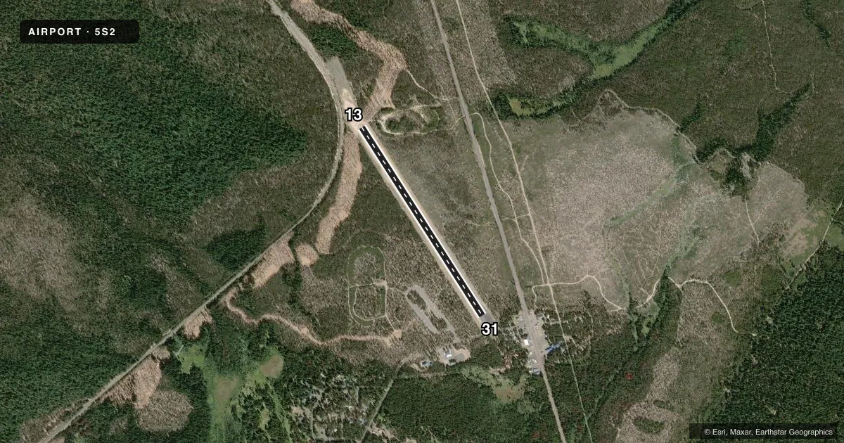
Runways & pattern
Full pagePattern entry · RWY 13
LEFT TRAFFICRunway end performance
| End | TORA | TODA | ASDA | LDA | VGSI | Approach lights | Obstruction |
|---|---|---|---|---|---|---|---|
| 13 | — | — | — | — | — | — | 188', trees, 1500' from thr, 145' R of cntrln, slope 6 |
| 31 | — | — | — | — | — | — | 69', trees, 379' from thr, 0' R of cntrln, slope 2 |
Declared distances in feet. TORA = takeoff run available, TODA = takeoff distance, ASDA = accelerate-stop, LDA = landing distance.
Airport sketch
Runways drawn to scale from FAA survey coordinates, rendered over satellite imagery. Not for navigation.
Approaches & charts
Services on the field
Fuel grades, oxygen, maintenance, ramp storage and lighting — as declared to the FAA by the airport operator.
Fuel & services
- Fuel
- Not available
- Oxygen (bottled)
- Not available
- Oxygen (bulk)
- Not available
- Airframe repair
- Not available
- Power plant repair
- Not available
Ramp & ground
- Transient storage
- Tie-down
- Landing fee
- No fee published
- Wind indicator
- Yes
- Segmented circle
- No
Fuel & FBOs
Cheapest 100LL and Jet A on the field and nearby. Always confirm with the FBO before taxi.
Airport notes
Surface conditions, obstructions, local procedures, lighting outages and other notes published with each FAA cycle.
General notes
- ARPT CLSD NOV 1-MAY 1 DUE TO SNOW
- OWNER ADVISES CTC WITH STATE DEPT. OF AVIATION, 503-378-4880.
- GRVL OCCASIONALLY ON RWY DUE TO RUN OFF.
- FOR CD CTC SEATTLE ARTCC AT 253-351-3694.
- SFC CONDS NOT RPRTD.
VFR map & nearby airports
VFR sectional. Tap any ICAO chip to open that airport.
Key facts · 5S2
Answer card- ICAO
- 5S2
- Name
- CRESCENT LAKE STATE
- Location
- CRESCENT LAKE, OREGON
- Elevation
- 4,819.7 ft MSL
- Traffic pattern altitude
- 5,819.7 ft MSL (1,000 AGL)
- Control tower
- Non-towered (use CTAF)
- Total runways
- 1
- Longest runway
- 13/31 · 3,608 ft
- Published ILS approaches
- 0
- Published frequencies
- 1
- Magnetic variation
- 18°
- Current flight rules
- VFR
- Current wind
- 000° at 0 kt
- Favored runway now
- –
Crescent Lake State sits at Crescent Lake, Oregon. The field elevation is 4,819.7 ft MSL. It has one runway, 13/31, which is 3,608 ft long and paved. This is a non-towered field. CTAF is 122.9. No ILS approaches are published here.
The pattern altitude is not published. Use the standard 1,000 ft AGL pattern unless the current Chart Supplement says otherwise. That puts the light aircraft pattern at about 5,819.7 ft MSL. The airport is closed from November 1 to May 1 because of snow. Surface conditions are not reported. Gravel can also show up on the runway after runoff, so a careful preflight and landing roll make sense here.
There are no on-field FBOs listed. Contact the airport operator directly before you go. The owner also asks pilots to contact the State Department of Aviation at 503-378-4880. For clearance delivery, Seattle ARTCC can be reached at 253-351-3694. At this elevation, density altitude and takeoff performance deserve attention, especially on warm days. Check the current FAA Chart Supplement before departure for any updates to operating status or local procedures.